Dürrnbachhorn
| Dürrnbachhorn | ||
|---|---|---|
| height |
1776 m above sea level NHN 1776 m above sea level A. |
|
| location | Bavaria , Germany and Salzburg , Austria | |
| Mountains | Chiemgau Alps | |
| Dominance | 5 km → Reifelberg | |
| Notch height | 630 m ↓ Winklmoos-Alm | |
| Coordinates | 47 ° 40 '26 " N , 12 ° 36' 32" E | |
|
|
||
| rock | Plattenkalk , main dolomite | |
| Age of the rock | Upper Carnium - Norium | |
| Development | Winklmoss chairlift Heutal lifts |
|
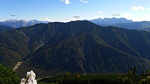
The Dürrnbachhorn is a mountain in the Chiemgau Alps , over whose summit ridge the border between Bavaria and Salzburg runs. Its height is 1776 m above sea level. NHN or 1776 m above sea level. A.
Location and structure
The Dürrnbachhorn is geomorphologically very similar to the Sonntagshorn ( 1961 m ) to the east and the Reifelberg ( Vorderlahnerkopf , 1909 m ). It has evenly sloping slopes to the south with forests, meadows and pine fields, but shows steep drops to the north that merge into the deeply torn wild house trenches . It is part of the Staufen-Höllengebirgsdecke ( Tirolikum ) and is made up of main dolomite and plate limestone , and in the deeper southern layers of the Kössen formation .
The border between the Salzburg municipality of Unken and the Bavarian municipality of Ruhpolding runs over the main summit of the Dürrnbachhorn . The area of the Bavarian community Reit im Winkl extends to the lower west summit. The summit ridge also forms the watershed between Alz and Salzach .
To the north of the Dürrnbachhorn lies the Seetraun valley with the Mittersee , Lödensee and Weitsee , which can be clearly seen from the summit cross. To the southwest, the extensive saddle on the Winklmoos-Alm ( 1146 m ) forms a connection to the Steinplatte ( 1869 m ). To the southeast is the Salzburg Heutal . On the south side of the mountain there are three larger alpine pastures: the Dürrnbachalm in Bavaria and the Finsterbachalm and Wildalm in Salzburg.
Tourist development
The Dürrnbachhorn is an easy mountain hike from the south and is accessible via several marked hiking trails. From the Winklmoos-Alm (or from Seegatterl ) a marked path leads over the Dürrnbachalm and over the summit ridge from the west to the summit. From the Heutal you can reach the summit via the Wildalm and the summit ridge from the east. In winter, these climbs are often done as a ski tour. Walter Schmidkunz succeeded in making the first direct ascent from the demanding north face on September 4, 1906.
The Dürrnbachhorn is accessible from two sides with lifts. In 1959 a single chair lift ( Winklmoos chairlift ) was opened from the Winklmoos Alm to the Dürrnbacheck (around 1610 m ) southwest of the main summit. Originally built for skiing on the Dürrnbachalm, the lift is only in operation in the summer months and offers a restaurant at the summit station. In 1971 T-bar lifts ( Heutal lifts ) were built from the Heutal via the Wildalm to the Riegerkaiser (around 1530 m ) southeast of the main summit. Plans to merge and build a ski swing have been made repeatedly since 1973.
Web links
Individual evidence
- ↑ State Office for Surveying and Geoinformation Bavaria : BayernAtlas (topographic map 1: 50,000) .
- ^ Federal Office for Metrology and Surveying Austria: Austrian Map online (Austrian map 1: 50,000) .
- ↑ Provisional Geological Map of the Republic of Austria 1: 50,000, published by the Federal Geological Institute , Vienna 2006, sheet 92 Lofer.
- ^ Announcements of the German and Austrian Alpine Club , Volume 33, Munich-Vienna 1907, p. 281.
- ↑ Walter Kellermann, Action Group for the Protection of the Saalforste and the Sonntaghorn: New Skischaukelplan Heutal / Winklmoos-Alm. (PDF; 969 kB) In: Salzburger Alpenvereinsnachrichten. P. 11–12 , accessed on November 6, 2014 (edition 03/2013).

