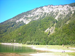
Lödensee
| Lödensee | ||
|---|---|---|

|
||
| Geographical location | Ruhpolding , Bavaria | |
| Tributaries | from Mittersee , Langer Sand | |
| Drain | (underground) Förchensee → Seetraun → Weisse Traun → Traun | |
| Places on the shore | Lödenalm | |
| Data | ||
| Coordinates | 47 ° 41 ′ 38 " N , 12 ° 35 ′ 41" E | |
|
|
||
| Altitude above sea level | 750.72 m above sea level NHN | |
| surface | 10.22 hectares | |
| length | 720 m | |
| width | 410 m | |
| scope | 2.1 km | |
| Maximum depth | 6.6 m | |
The Lödensee is a lake in the municipality of Ruhpolding between Ruhpolding and Reit im Winkl with an area of 10.22 hectares and a maximum depth of 6.0 meters. It is located in the district Seehauser forest of Ruhpolding.
The lake is located in the three lakes area (the other lakes are Weitsee and Mittersee ) and extends with the other two lakes in the valley between Gurnwandkopf and Dürrnbachhorn , directly on the German Alpine Road (B305). The Lödensee is not clearly separated from the Mittersee. The narrowest point between Mittersee and Lödensee is between 10 and 100 meters wide, depending on the water level.
Bathing has not been recommended since 2017, the water quality suffers from the adjacent cow pastures and manure / feces on the lawn.
To the northeast of the lake is the Lödenalm .
