
Weitsee
| Weitsee | ||
|---|---|---|

|
||
| Geographical location | Chiemgau Alps | |
| Tributaries | Großer Wappbach, Kleiner Wappbach, Salzmaiergraben | |
| Drain | Mittersee → Lödensee → (underground) Förchensee → Seetraun → Weisse Traun → Traun → Alz → Inn → Danube | |
| Places on the shore | Seegatterl , Seefischerkaser | |
| Location close to the shore | Reit im Winkl | |
| Data | ||
| Coordinates | 47 ° 40 '58 " N , 12 ° 33' 40" E | |
|
||
| Altitude above sea level | 753 m above sea level NN | |
| surface | 63.6 ha | |
| length | 2.67 km | |
| width | 250 m | |
| volume | 2,217,000 m³ | |
| scope | 7.6 km | |
| Maximum depth | 9.30 m | |
| Middle deep | 3.50 m | |
|
particularities |
separated Obersee |
|

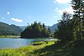
The Weitsee is a lake in the municipality of Reit im Winkl between Ruhpolding and Reit im Winkl with an area of 63.60 hectares and 9.3 m maximum and 3.5 m average depth.
description
The lake is located in the three lakes area in the eastern Chiemgau Alps nature reserve (the other lakes are Mittersee and Lödensee ) and extends with the other two lakes in the valley between Gurnwandkopf and Dürrnbachhorn directly on the German Alpine Road (B305). The runoff takes place via the Mittersee and the Lödensee, the water seeps into the area heaped up by the Langen Sand , a scree field on the north side of the Dürrnbachhorn. Studies have shown that part of the water flows under the Hochgern through to Bergen (in the Chiemgau) and reappears there in the Bergen moor.
In the part of the lake Obersee with a size of around 15 hectares, which is cut off by the mountainous Bürgl peninsula jutting into the lake from the south, lies the 0.8 hectare island of Bidlieger . This part of the lake, which is only 50 cm deep in places, is most affected by the siltation. At the narrowest point between the two parts of the lake (almost 30 meters) there is an approx. 5 m deep spring pot .
The lack of larger above-ground tributaries has a positive effect on the water quality, which is why all three lakes are often used as bathing lakes in summer. In winter, the cross-country ski trail leads from Reit im Winkl to Ruhpolding over the frozen lake area.
Parts of the shore are home to rare and protected species such as the Siberian iris and the brown eye (Mionis dryas) .

Weitsee in autumn (Obersee with Bidlieger Island)

Weitsee from the west ...
and from the east


See also
Web links
swell
- ↑ Archived copy ( Memento of the original from September 28, 2007 in the Internet Archive ) Info: The archive link was inserted automatically and has not yet been checked. Please check the original and archive link according to the instructions and then remove this notice.