North Tyrolean Limestone Alps
| North Tyrolean Limestone Alps | |
|---|---|
|
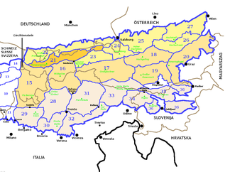
The North Tyrolean Limestone Alps (section 21) according to SOIUSA within the Eastern Alps |
|
|
the Parseierspitze , the highest peak in the North Tyrolean Limestone Alps |
|
| Highest peak | Parseierspitze ( 3040 m above sea level ) |
| location |
Vorarlberg and Tyrol ( Austria ), Bavaria ( Germany ) |
| part of | Northern Eastern Alps |
| Classification according to | SOIUSA : 21 |
| Coordinates | 47 ° 20 ′ N , 11 ° 0 ′ E |
The North Tyrolean Limestone Alps are a section of the Northern Eastern Alps in the international standardized orographic division of the Alps (SOIUSA) according to Sergio Marazzi .
classification
| Classification according to SOIUSA | ||
|---|---|---|
| part | II | Eastern Alps |
| sector | II / B | Northern Eastern Alps |
| section | 21st | North Tyrolean Limestone Alps |
The North Tyrolean Limestone Alps have no direct equivalent in other classification systems. The subsections of the North Tyrolean Limestone Alps each correspond to a group of the Alpine Association classification of the Eastern Alps (AVE) . The Partizione delle Alpi uses the term Bavarian Alps for the entire area of the SOIUSA sections of the North Tyrolean Limestone Alps and Bavarian Alps west of the Inn .
Boundary
The limit of the North Tyrolean Limestone Alps runs in a clockwise direction along the line Lutz - Seebergbach - Faschinabach - Faschinajoch - Argenbach - Bregenzer Ach - Hochtannbergpass - Krumbach - Lech - Archbach - Plansee - Heiterwanger See - Zwischenentoren - Loisach - Partnach - Kankerbach - Köchelgraben - Kranzbach - Isar - Seeache - Ampelsbach - Filzmoosbach - Gufferthütte - Sattelbach - Bairache - Brandenberger Ache - Ellbach - Glemmbach - Thierseer Ache / Klausenbach / Kieferbach - Inn - Jennbach - Walchsee - Walchseebach - Weißenbach - Kohlenbach - Großache - Reither Ache - Goinger Bach - Ellmauer Sattel - Weißache - Inn - Sanna - Rosanna - Arlbergpass - Alfenz - Ill .
| The Bavarian Alps | ||

|
Salzburg Northern Alps | |
| Western Rhaetian Alps | Eastern Rhaetian Alps | Tyrolean Slate Alps |
Breakdown
The North Tyrolean Limestone Alps are divided into three sectors and six subsections.
| sector | Subsection | Correspondence in the AVE | Highest peak | height | |||
|---|---|---|---|---|---|---|---|
| A. | Lechtal Alps i. w. S. (Western North Tyrolean Limestone Alps) |
I. | Lechtal Alps i. e. S. | 3b | Lechtal Alps | Parseier point | 3036 m above sea level A. |
| II | Klostertal Alps ( Lechquellen Mountains ) |
3a | Lechquellen Mountains | Lower Wildgrubenspitze | 2753 m above sea level A. | ||
| B. | Innsbruck Alps (Central North Tyrolean Limestone Alps) |
III | Mieminger and Wetterstein Mountains | 4th | Wetterstein Mountains and Mieming Range | Zugspitze | 2962 m |
| IV |
Karwendel Mountains i. w. S. (Karwendel and Risser Mountains) |
5 | Karwendel | Birkkarspitze | 2749 m above sea level A. | ||
| C. | Rofan and Kaiser Mountains (Eastern North Tyrolean Limestone Alps) |
V |
Brandenberg Alps (Rofan Mountains i. W. S.) |
6th | Brandenberg Alps | Hochiss | 2299 m above sea level A. |
| VI | Kaiser Mountains | 8th | Kaiser Mountains | Ellmauer stop | 2344 m above sea level A. | ||
literature
- Sergio Marazzi : Atlante orografico delle Alpi. SOIUSA - Suddivisione orografica internazionale unificata del Sistema Alpino . 1st edition. Priuli & Verlucca, Scarmagno 2005, ISBN 88-8068-273-3 (Italian, abstract [PDF; 1.6 MB ; accessed on December 26, 2016]).

