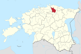
Kadrina
| Kadrina | |||
|
|||
| State : |
|
||
| Circle : |
|
||
| Coordinates : | 59 ° 20 ' N , 26 ° 9' E | ||
| Area : | 329.26 km² | ||
| Residents : | 4,908 (January 1, 2018) | ||
| Population density : | 15 inhabitants per km² | ||
| Time zone : | EET (UTC + 2) | ||
| Postal address : | Rakvere tee 14 45201 Kadrina |
||
| Website : | |||

|
|||
Karina (German Sankt Katharinen ) is a rural municipality in the west of the Lääne-Viru district in Estonia and was founded in 1988 in its current form.
The municipality makes up 10% of the total area of the Lääne-Viru County. Its northern border is also the southern border of the Lahemaa National Park .
history
The area of the municipality of Kadrina was probably first settled between the 5th and 8th centuries and was part of the historical Repeli area.
The Teutonic Order conquered the area in 1219. A year later, in 1220, the Danes founded the parish of Torvestavere , later called Tristfer . The current church is dated to the 15th century. Saint Catherine became the patroness of the parish, from which the name Kadrina is derived.
The completion of the Tallinn - Saint Petersburg railway in 1870 gave a decisive impetus to the development of the community. This year the wooden train station was built. Alongside tapa, Kadrina was an important stop on the route.
In 1902 the local school was established for the community, and in 1907 the Kadrina Society of Education .
The monument on field stones to commemorate the fallen from Kadrina in World War I and the Estonian War of Independence was erected in front of the church in 1926.
structure
In addition to the main town of Kadrina (approx. 2600 inhabitants), the municipality also includes the villages of Ama, Arbavere , Härjadi, Hõbeda , Hulja, Jõepere, Jõetaguse , Kadapiku, Kallukse, Kihlevere, Kõrveküla, Lante, Leikude, Loobu, Läsna, Mäõndavere, Neo ( Buxhoewden ), Ohepalu, Põima, Ridaküla, Rõmeda, Tirbiku, Tokolopi, Udriku ( Uddrich ), Kiku, Salda, Pariisi, Uku, Undla, Vaiatu, Vandu, Viitna, Vohnja, Võduvere and Võipere.
geography
The ridges left by the last Ice Age are an interesting form of landscape in the municipality of Kadrina. In the Neeruti landscape protection area , the ridges stand side by side in rows of 2 or 3, which is why they are also called the furrows of Kalevipoeg , the Estonian national hero. Similar structures can also be seen in Kallukse , Vohnja and Vatku .
The Loobu River flows through the community 50 km from south-east to north-west. It has its source at the Jõepere and Pundi springs and is suitable for canoeing . The river banks are mostly swampy and overgrown with undergrowth. The rivers Loobu and Läsna as well as Udriku and Vaiatu are spawning grounds for salmon.
The municipality of Kadrina is partly in the area of the Pandivere National Water Protection Area and more than a fifth of the Lahemaa National Park is in the municipality.
Community partnerships
- since November 26, 1989 with Janakkala / Finland
- since May 4, 1996 with Mora / Sweden
- since January 24, 1996 with Trøgstad / Norway
traffic
The municipality is crossed by the following arteries:
- Highway 1 Tallinn- Narva ( European route E20)
- Road 5 Pärnu - Sõmeru
- Highway 24 Loobu -Tapa
and the
- Railway line Tallinn-St. Petersburg
Others
Friedrich Reinhold Kreutzwald was born in the municipality of Kadrina.
Some pastors of the Church of Kadrina such as Heinrich Stahl (1633–1638), Reiner Brocmann (1639–1647), Joachim Gottlieb Schwabe (1754–1800) and Arnold Friedrich Johann Knüpffer (1800–1843) have made significant contributions to the development of Estonian literature . To commemorate this, the Estonian Language Monument was erected in 1994 .

