
Kuusalu
| Kuusalu | |||
|
|||
| State : |
|
||
| Circle : |
|
||
| Coordinates : | 59 ° 27 ' N , 25 ° 26' E | ||
| Area : | 708 km² | ||
| Residents : | 6,371 (01.2010) | ||
| Population density : | 9 inhabitants per km² | ||
| Time zone : | EET (UTC + 2) | ||
| Postal address : | Mõisa tea 17 74604 Kiiu |
||
| Website : | |||

|
|||


Kuusalu (German Kusal ) is a rural community in the Estonian district of Harju ( Harju maakond ) with an area of 708 km². It has 6,371 inhabitants (as of July 1, 2010). Kuusalu is located about 39 km from Tallinn in the north-east of Harju County. With the accession of the municipality of Loksa ( Loksa vald ) to the municipality of Kuusalu on October 20, 2005, it has become the largest municipality in the district in terms of area.
Villages
In addition to the main town of Kuusalu (1227 inhabitants), the municipality includes the villages of Allika, Andineeme, Aru, Haavakannu, Hara, Hirvli , Ilmastalu, Joaveski, Juminda, Kaberla, Kahala, Kalme, Kasispea, Kemba, Kiiu, Kiiu-Aabla, Kodasoo, Koitjärve , Kolga-Aabla, Kolga , Kolga küla, Kolgu, Kosu, Kotka, Kupu, Kursi, Kuusalu küla, Kõnnu, Külmaallika, Leesi , Liiapeeksi, Loksa küla, Murksi, Mustametsa, Muuksi, Mäepea, Naspea, Pedaspea, Palaõea, Parksi Pudisoo, Põhja, Pärispea, Rehatse, Rummu, Salmistu, Saunja, Sigula, Sõitme, Soorinna, Suru, Suurpea, Tammispea, Tammistu, Tapurla, Tsitre, Turbuneeme, Tõreska, Uuri, Vahastu, Valgejõe, Valkla, Vanaküla, Vihasoo, Viinistu and Virve.
Attractions
The monk's tower of Kiiu (German: Kida or Kyda Castle ) from the 16th century is worth seeing . The four-storey defense tower is the oldest surviving fortress in Estonia. Today it is used as a café. Kiiu is also known for its eggnog .

The Laurentius Church in Kuusalu

Mohni lighthouse
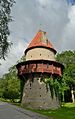
Kiiu monk's tower

Kolga manor

Viru turned in winter

Coast of the Pärispea peninsula

Suru Suursoo in the early morning

Nõmmeveski waterfall
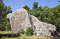
Jaani-Tooma boulder


Web links
- Website of the municipality of Kuusalu (Estonian)