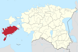
Saaremaa (rural municipality)
| Saaremaa | |||
|
|||
| State : |
|
||
| Circle : |
|
||
| Founded : | 2017 | ||
| Coordinates : | 58 ° 20 ′ N , 22 ° 30 ′ E | ||
| Area : | 2,705 km² | ||
| Residents : | 32,007 (January 1, 2017) | ||
| Population density : | 12 inhabitants per km² | ||
| Time zone : | EET (UTC + 2) | ||
| Community type: | Rural community | ||
| Structure : | 1 city, 9 large villages, 427 villages | ||
| Website : | |||

|
|||
Saaremaa is a rural municipality in the Saare district in Estonia . In addition to the island of the same name, it also includes its surrounding islands. Saaremaa was founded in 2017 and has been the municipality with the largest area in Estonia ever since.
The rural community was created through the merger of the city of Kuressaare and the rural communities of Kihelkonna , Lääne-Saare , Laimjala , Leisi , Mustjala , Orissaare , Pihtla , Pöide , Salme , Torgu and Valjala . Originally, Ruhnu should also be part of the rural community.
In addition to the main town, Kuressaare , the municipality consists of nine large villages ( Aste , Kärla , Kihelkonna , Kudjape , Leisi , Nasva , Orissaare , Salme and Valjala ) and 427 villages.
Web links
Commons : Landgemeinde Saaremaa - Collection of pictures, videos and audio files
proof
- ↑ Community overview 2017
- ↑ Margus Muld: Omavalitsusjuhtidele tuli üllatusena komisjoni ettepanek Ruhnu sundliitmise kohta on err.ee, accessed on November 26, 2017

