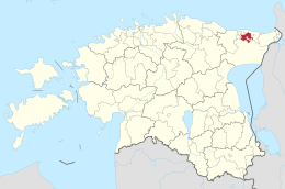
Jõhvi
| Jõhvi Rural Municipality ( Jõhvi vald ) | |||
|
|||
| State : |
|
||
| Circle : |
|
||
| Coordinates : | 59 ° 20 ′ N , 27 ° 23 ′ E | ||
| Area : | 116.45 km² | ||
| Residents : | 12,665 (2012) | ||
| Population density : | 109 inhabitants per km² | ||
| Time zone : | EET (UTC + 2) | ||
| Postal code : | 31026, 41531-41599 | ||
| Community type: | Rural community | ||
| Mayor : | Tauno Võhmar
( Reformierakond ) |
||
| Postal address : | Keskväljak 4 41595 Jõhvi |
||
| Website : | |||

|
|||
The rural community of Jõhvi ( Jõhvi vald ) is located in northeast Estonia in Ida-Viru County .
geography
The area of the rural community is 116.45 km². It has 12,665 inhabitants (as of July 1, 2012). The population density is 109 inhabitants per square kilometer.
structure
The main town of the rural community is Tammiku . The rural community includes the town of Jõhvi and the villages of Edise , Jõhvi , Kahula , Kose , Kotinuka , Linna , Pajualuse , Pargitaguse , Pauliku , Puru , Sompa and Tammiku.
history
In 1946, extensive mining of oil shale began in the municipality . On the one hand, this led to a large influx of workers into the community and, on the other hand, to major environmental problems. The gradual decline in oil shale mining in Estonia presents the community with so far unsolved social challenges.
people
- Hans Hindpere (1928–2012), composer
- Harri Tiido (* 1953), diplomat
- Andrei Hvostov (* 1963), essayist, writer and journalist
Web links
- Official website (Estonian and Russian)
- AS Eesti Põlevkivi - Oil shale mining in Ida-Virumaa (Estonian, Russian and English)
Individual evidence
- ↑ Archived copy ( memento of the original dated November 4, 2017 in the Internet Archive ) Info: The archive link was inserted automatically and has not yet been checked. Please check the original and archive link according to the instructions and then remove this notice.

