
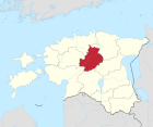
Järva County
| coat of arms | map |
|---|---|

|
  |
| Basic data | |
| ISO code : | EE-51 |
| Administrative headquarters : | Paide (Weissenstein) |
| Area : | 2,461 km² 1 |
| Residents : | 30,425 (January 1, 2014) 2 |
| Population density : | 15 inhabitants / km² |
| Circle structure: | 1 city 1 2 municipalities |
| Website : | www.jarva.ee |
| politics | |
| District Administrator: | Üllar Vahtramäe 2004 |
|
Notes : 1 2005 downsizing of the district to the community Lehtse (163 square kilometers) that the county Lääne-Viru comes also the communities Kabala, Oisu and Türi were merged with the city of Türi to a community, see Place Names Board of Estonia (English ) 2 Estonia Statistics Office, database request, September 12, 2014 |
|
The county Järva ( Estonian Järva maakond or Järvamaa , German Jerwen ) is a county (maakond) in Estonia .
In the north the terrain is quite flat and partly swampy. The southern part of the district is mainly occupied by densely forested hills. In the southeast is the Endla nature reserve . Agriculture is the dominant industry.
Communities

Since the administrative reform of 2017, Järvamaa has been divided into a city (Estonian linn ) and two municipalities (Estonian vald ):
Cities :
- Paide (German: Weißenstein )
Municipalities :
Former parishes :
- Albu (Alp)
- Ambla (traffic light)
- Imavere (Immafer)
- Järva-Jaani (Sankt Johannis)
- Kareda
- Koeru (Saint Mary Magdalene)
- Koigi (Koik)
- Paide (municipality) (Weißenstein)
- Roosna-Alliku (Kaltenbrunn)
- Väätsa (Waetz)
Web links
Commons : Järva County - collection of pictures, videos and audio files


