
Saare district
|
|||
| Basic data | |||
|---|---|---|---|
| ISO code : | EE-74 | ||
| District: | Saare Maakond | ||
| Administrative headquarters: | Kuressaare (Arensburg) | ||
| Geographical location: | 58 ° 24 ' N , 22 ° 31' E | ||
| Surface: | 2672 km² | ||
| Residents: | 31,756 (January 1, 2014) 1 |
||
| Population density: | 12 inhabitants per km² | ||
| Community structure: | 3 municipalities | ||
| highest elevation: | Viidu Raunamägi (54 m) | ||
| Address of the district administration: | Tallinna 10, Kuressaare | ||
| Official Website: | www.saaremaa.ee | ||
|
1 Estonia Statistics Office, database request, September 12, 2014 |
|||


Saare (Estonian Saare maakond , German Ösel district ) is an administrative district ( Maakond ) in Estonia . It consists of the eponymous island of Saaremaa , the surrounding islands of Muhu (poppy seeds) , Abruka (Abro) , Vilsandi (Filsand) , Ruhnu (Runö) and various smaller islands. The administrative seat is in Kuressaare (Arensburg) in the south of the main island .
politics
The district administration ( maakonnavalitsus ) is headed by a district prefect ( maavanem ), who is appointed by the Estonian government for five years.
Community structure


The Saare district has consisted of three rural communities since 2017. All municipalities (except Muhu and Ruhnu) and the city of Kuressaare merged to form the rural municipality of Saaremaa.
| local community | Area km² |
Residents | Population density / km² |
|
|---|---|---|---|---|
| 1 | Muhu (poppy seeds) | 206 | 2,169 | 10.5 |
| 2 | Ruhnu (Runö) | 11.5 | 72 | 6.3 |
| 3 | Saaremaa | 2,686 | 37,437 | 13.9 |
| Saare Maakond (Ösel) | 2,904 | 39,678 | 13.7 |
From 2014 to 2017 the Saare district consisted of thirteen rural communities and the city of Kuressaare. In 2014 the municipalities of Kaarma ( Karmel ), Kärla ( Kergel ) and Lümanda ( Lümmada ) merged to form the municipality of Lääne-Saare .
| local community | Area km² |
Residents | Population density / km² |
|
|---|---|---|---|---|
| 1 | Kihelkonna (Kielkond) | 246 | 1,097 | 4.5 |
| 2 | Kuressaare (Arensburg) | 15th | 16,111 | 1,074 |
| 3 | Lääne-Saare (West Ösel) | 817 | 7,215 | 8.3 |
| 4th | Laimjala (Laimjall) | 116 | 934 | 8.0 |
| 5 | Leisi (Laisberg) | 348 | 2,521 | 7.2 |
| 6th | Muhu (poppy seeds) | 206 | 2,169 | 10.5 |
| 7th | Mustjala (Mustel) | 236 | 926 | 3.9 |
| 8th | Orissaare (Orrisaar) | 136 | 2,391 | 17.6 |
| 9 | Pihtla (Pichtendahl) | 228 | 1,616 | 7.1 |
| 10 | Poide (Peude) | 123 | 1,134 | 9.2 |
| 11 | Ruhnu (Runö) | 11.5 | 72 | 6.3 |
| 12 | Salme | 115 | 1,371 | 11.9 |
| 13 | Torgu (Torken) | 126 | 468 | 3.7 |
| 14th | Valjala (Wolde) | 180 | 1,653 | 9.2 |
| Saare Maakond (Ösel) | 2,904 | 39,678 | 13.7 |

The Arensburg in Kuressaare
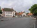
Kuressaare city center

Windmills in Angla

Old Estonian hill fort on Muhu with a memorial stone


