
Leisi (rural community)
| Leisi (rural community) | |||
|
|||
| State : |
|
||
| Circle : |
|
||
| Coordinates : | 58 ° 34 ' N , 22 ° 42' E | ||
| Area : | 274.91 km² | ||
| Residents : | 2,127 (01.2006) | ||
| Population density : | 8 inhabitants per km² | ||
| Time zone : | EET (UTC + 2) | ||
| Community type: | former rural community | ||

|
|||


Leisi (German: Laisberg ) is a former rural community in the Estonian Saare district with an area of 347.91 km². It had 2,127 inhabitants (as of January 1, 2006). In 2017 all municipalities on Saaremaa merged to form the new rural municipality Saaremaa .

Leisi was in the north of the island of Saaremaa . Since 1990 there has been a community partnership with Karis ( Finnish : Karjaa ) in south-west Finland .
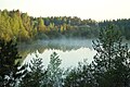
The historical parish of Karja (German: Karrishof ) on the area of today's Leisi was mentioned in a document as early as the 13th century. The early Gothic church of Karja from the 14th century as well as the orthodox churches of Leisi and Metsküla from the 19th century were worth seeing . The untouched coastal landscape was ideal for hiking.
Villages
In addition to the main town of Leisi ( Leisi alevik ), the rural community included the villages Angla , Aru , Aruste , Asuka , Hiievälja , Jõiste , Kaisa , Karja , Koiduvälja , Koikla , Kopli , Külma , Laugu , Liiva , Linnaka , Linnuse , Lõpi , Luulupe , Mätja , Meiuste , Metsaääre , Metsküla , Moosi , Mujaste , Murika , Nava , Nihatu , Nõmme , Nurme , Öste , Oitme , paaste , Pärsama , Pamma , Pammana , Parasmetsa , Peederga , Pöitse , Poka , Purtsa , Räägi , Ratla , Roobaka , Selja , Soela , Täätsi , Tareste , Tiitsuotsa , Tõre , Triigi , Tutku , Veske and Viira .
gallery
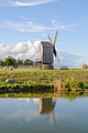
Angla

Karja
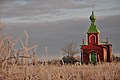
Metsküla
Tika

Triigi

Triigi

Tuhkana


