
Pöide (rural community)
| Pöide | |||
|
|||
| State : |
|
||
| Circle : |
|
||
| Coordinates : | 58 ° 31 ' N , 23 ° 4' E | ||
| Area : | 123.6 km² | ||
| Residents : | 880 (2016) | ||
| Population density : | 7 inhabitants per km² | ||
| Time zone : | EET (UTC + 2) | ||
| Community type: | former rural community | ||
| Structure : | 30 villages | ||
| Postal address : | Rahvamaja 94501 Tornimäe |
||

|
|||


Pöide (Pöide vald) is a former rural community in the east of the largest Estonian island Saaremaa . Administratively it belonged to the Saare district . In 2017 all municipalities on Saaremaa merged to form the new rural municipality Saaremaa .
coat of arms
The coat of arms of the municipality with the battlements and the lily cross reminds of the medieval castle of the Teutonic Order , which marks the founding history of the region. The yellow gold color of the coat of arms alludes to the Virgin Mary , to whom the church of Pöide was consecrated in the middle ages .
Villages
In addition to the main town Tornimäe the rural municipality included the villages Ardla , Are , Iruste , Kärneri , Kahutsi , Kakuna , Kanis Saare , Keskvere , Koigi , Kõrkvere , Kübassaare , Leisi , Levala , Metsara , Mui , Muraja , Neemi , Nenu , Oti , Puka , Pöide , Reina , Sundimetsa , Talila , Ula , Unguma , Uuemõisa , Välta and Veere .
Islands
The rural community also included the smaller islands of Aavilaid , Anulaid , Kalmelaid , Kõrgelaid , Lehmlaid , Loomalaid , Madallaid , Oitma laid , Pihlalaid , Pikklaid , Pisselaid , Rooglaid , Suuregilaid , Suutselaid , Tumalaid , Udriku laid and Villemi laid .
photos
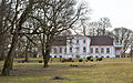
Oti mansion
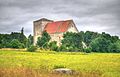
Evangelical Lutheran Church in Pöide

Orthodox Church in Tornimäe

Dendrarium in Neemi

Kübassaare lighthouse


