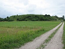
Kahutsi
Coordinates: 58 ° 31 ' N , 23 ° 1' E
Kahutsi is a village ( Estonian küla ) on the largest Estonian island of Saaremaa . It belongs to the rural community Saaremaa (until 2017: rural community Pöide ) in the Saare district .
Population, location and history
The village has 29 inhabitants (as of December 31, 2011). It is 43 kilometers northwest of the island's capital Kuressaare .
The place was first mentioned in the 15th century under the name Kaghovere .
Wallburg
The remains of a hill fort of the pagan Estonians from the 12th century can be found southwest of the village center . The inner ring wall was up to 5.7 meters high, the outer up to 11 meters.
The castle was first mentioned in the Chronicle of Henry of Livonia written at the beginning of the 13th century . It has so far been little researched archaeologically .
literature
- Baltic historical local dictionary. Part 1: Estonia (including Northern Livonia) (= sources and studies on Baltic history. Volume 8/1). Started by Hans Feldmann . Published by Heinz von zur Mühlen . Edited by Gertrud Westermann . Böhlau, Cologne / Vienna 1985, ISBN 3-412-07183-8 , p. 166.
Web links
- Entry in Eesti Entsüklopeedia (online version)

