Kaimri
Coordinates: 58 ° 4 ′ N , 22 ° 12 ′ E
Kaimri (German Kaimern ) is a village ( Estonian küla ) on the largest Estonian island Saaremaa . It belongs to the Saaremaa rural community (until 2017: Salme rural community ) in the Saare district .
description
The place on the east coast of the Sõrve peninsula has seven inhabitants (as of December 31, 2011). It is located 26 kilometers southwest of the island's capital Kuressaare .
In the second half of the 19th century there was a small Orthodox school on site. She stopped teaching in 1872.
Anti-tank line
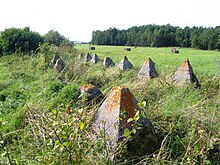
Between Kaimri on the east coast and Lõpe, just under three kilometers away on the west coast of the peninsula, there was a double-row anti-tank line made of concrete pyramids, which the Red Army had built against the German Wehrmacht in October 1941 . In 1944, the German troops reinforced this line as a defense against the Soviet armed forces.
During the Second World War, bitter fighting between German and Soviet troops took place on this narrow isthmus. A small memorial near Lõpe, built in 1969, commemorates them.
literature
- Baltic historical local dictionary. Part 1: Estonia (including Northern Livonia) (= sources and studies on Baltic history. Volume 8/1). Started by Hans Feldmann . Published by Heinz von zur Mühlen . Edited by Gertrud Westermann . Böhlau, Cologne / Vienna 1985, ISBN 3-412-07183-8 , p. 167.

