Karala
Coordinates: 58 ° 16 ' N , 21 ° 54' E

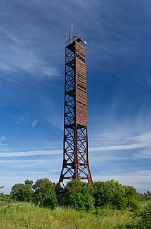
Beacon at Karala
Karala (German Karral ) is a village ( Estonian küla ) on the largest Estonian island Saaremaa . It belongs to the rural municipality Saaremaa (until 2017: rural municipality Lääne-Saare ) in the Saare district .
description
The village has 74 inhabitants (as of January 1, 2016). It is located on the west coast of Saaremaa Island.
The place is located 33 kilometers west of the island's capital Kuressaare . To the east of the town center are the two lakes Nonni järv and Tõrijärv .
A 28 meter high beacon was erected in Karala in 1953 . It is 42 meters above sea level.
literature
- Baltic historical local dictionary. Part 1: Estonia (including Northern Livonia) (= sources and studies on Baltic history. Volume 8/1). Started by Hans Feldmann . Published by Heinz von zur Mühlen . Edited by Gertrud Westermann . Böhlau, Cologne / Vienna 1985, ISBN 3-412-07183-8 , p. 189.
Web links
- Description (eestigiid.ee)
Individual evidence
- ↑ Municipal administration Lääne-Saare ( Memento of the original from December 22, 2016 in the Internet Archive ) Info: The archive link has been inserted automatically and has not yet been checked. Please check the original and archive link according to the instructions and then remove this notice. , accessed November 7, 2016
