Beacon
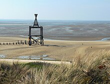
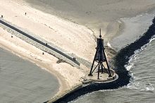
As a beacon or Cape (also Kaap) is now referred to in Seezeichenwesen fixed beacons, the unfired or after its type or size is not the criteria of a lighthouse met. Mostly, beacons are used for spatial orientation of road users.
The Scharhörnbake, which was first erected in 1661, was the highest beacon on the North Sea coast from 1898 to December 23, 1914 at 29.10 m.
history
The word beacon comes from Low German . In the Middle Ages, the term beacon was understood to mean something like signs (for orientation) . At that time, the first floating buoys that were laid out were also called beacons .
Todays situation
The beacon is one of the nautical signs used in shipping . It is often used to mark fairways . Beacons are set up near the shore and are constructions made of wood, steel or stone. They are often given a striking shape (similar to a pyramid or a tower) and typical colors, as well as a corresponding top mark at the top.
One example is the Mühlenbake : Swinemünde's landmark on the western pier built between 1818 and 1823. The navigation mark was built in 1874, the wings were initially still turning, creating the blinking beacon.
Furthermore, poles and pricks serve as fixed sea marks and belong to the beacons as well as marks for the deck bearing . In contrast, the floating navigation marks are intended for direct marking of the fairway. There are mostly tons and occasionally lightships .
Special forms
Moreover, there are so-called underwater locator beacons, which are dropped and being submerged in water on a single battery charge a high frequency locator signal (25 - 50 kHz) of 160 dB for a period of more than thirty days can deliver, which then of recorders Voyage Data recorded becomes. Such signals can affect the marine mammal's tracking system and cause severe physiological damage.
Another special form are the life beacons set up near the coast . They serve as a refuge for people in distress at sea .
After all, mileage beacons are used to calibrate the log as it drives by. There are two or more pairs of beacons at a certain distance from the fairway. The extension of a line through the two beacons of a pair marks a certain point in the fairway. The speed of the ship can be determined based on the passage times of these points. Such measuring sections are currently (as of 2011) on the Elbe and Weser.
See also
literature
- Gerhard Wiedemann (eds.), Johannes Braun, Hans Joachim Haase; The German navigation system . 1850-1990; between sailing and container shipping [in cooperation with the German Maritime Museum Bremerhaven]. DSV, Hamburg 1998, ISBN 3-8841-2275-4
- Arend Lang : History of the nautical sign system. Development, establishment and administration of the navigation system on the German North Sea coast until the middle of the 19th century . Ed .: The Federal Minister of Transport. Bonn 1965.
- Hans-Joachim Luttermann: Flowers, beacons, fire towers . In: Maritime Miniatures . Hinstorff, Rostock 1986, ISBN 3-356-00036-5 .
- Georg Quedens: Amrum sea mark . Beacons, buoys and beacons. Quedens, Amrum 2000, ISBN 3-924422-64-8 .
Individual evidence
- ↑ Leuchttuerme.net - beacons (and capes). In: Leuchttuerme.net. Retrieved December 29, 2016 .
- ↑ Tourist Map - Wollin Island and Surroundings, Warsaw 2012.
- ↑ Manufacturer's website for underwater location beacons ( page no longer available , search in web archives ) Info: The link was automatically marked as defective. Please check the link according to the instructions and then remove this notice.


