Koeru
| Koeru | |||
|
|||
| State : |
|
||
| Circle : |
|
||
| Coordinates : | 58 ° 58 ′ N , 26 ° 2 ′ E | ||
| Area : | 236.82 km² | ||
| Residents : | 2,315 (2010) | ||
| Population density : | 10 inhabitants per km² | ||
| Time zone : | EET (UTC + 2) | ||
| Website : | |||

|
|||
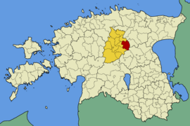
Koeru ( Koeru vald ) ( German Sankt Marien-Magdalenen ) was a rural community in the Estonian district of Järva with an area of 236.8 km². It has 2315 inhabitants (as of December 2010).
In addition to the main town Koeru (1073 inhabitants), the municipality included the villages of Abaja, Aruküla , Ervita, Jõeküla, Kalitsa, Kapu, Koidu-Ellavere, Kuusna, Laaneotsa, Luisvere, Merja, Norra, Preedi, Puhmu, Rõhu, Salutaguse, Santovi, Tammiku , Tudre, Udeva, Vahuküla, Valila, Vao, Visusti, Vuti and Väinjärve.
The parish of Koeru was first documented in 1282. The Maria Magdalena Church in Koeru was consecrated in 1288, later expanded and, with its 43.5 m high tower, is the most famous sight of the community today.
In the vicinity of Koeru is the 349 meter high Koeru transmission mast , the tallest structure in Estonia .
Web links
- Koeru Municipality website (Estonian)
- Full description (Estonian)


