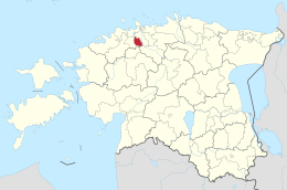
Kiili
| Kiili | |||
|
|||
| State : |
|
||
| Circle : |
|
||
| Coordinates : | 59 ° 19 ′ N , 24 ° 51 ′ E | ||
| Area : | 100.4 km² | ||
| Residents : | 5,229 (2015) | ||
| Population density : | 52 inhabitants per km² | ||
| Time zone : | EET (UTC + 2) | ||
| Website : | |||

|
|||
Kiili is a rural community in Harju County, Estonia, with an area of 100.4 km². It has 5229 inhabitants (as of 2015).
In addition to the main town of Kiili (865 inhabitants), the municipality includes the villages of Arusta, Kangru, Kurevere, Luige, Lähtse, Metsanurga, Mõisaküla, Nabala , Paekna, Piissoo, Sausti, Sookaera, Sõgula, Sõmeru and Vaela.
Until 1971, Kiili was officially called Veneküla ( Russendorf ). The name (documented since 1798) refers to the Russians who settled in the place after the Northern War .
Web links
- Website of the municipality of Kiili (Estonian)
Individual evidence
- ↑ pub.stat.ee (accessed February 24, 2016)

