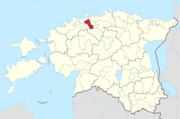
Rae (Estonia)
| Rae | |||
|
|||
| State : |
|
||
| Circle : |
|
||
| Coordinates : | 59 ° 23 ' N , 24 ° 53' E | ||
| Area : | 206.7 km² | ||
| Residents : | 12,680 (1/2011) | ||
| Population density : | 61 inhabitants per km² | ||
| Time zone : | EET (UTC + 2) | ||
| Website : | |||

|
|||
Rae (German: Johannishof ) is a rural community in the Estonian district of Harju with an area of 206.7 km². It has 12,680 inhabitants (as of January 1, 2011).
In addition to the main town of Jüri (3350 inhabitants), the municipality includes the villages of Aaviku, Aruvalla, Assaku, Järveküla, Kadaka, Karla, Kautjala, Kopli, Kurna, Lehmja, Lagedi , Limu, Pajupea, Patika, Peetri , Pildiküla, Rae, Salu, Seli , Soodevahe, Suuresta, Suursoo, Tuulevälja, Ülejõe, Urvaste, Vaida, Vaidasoo, Vaskjala, Veneküla and Veskitaguse.
The villages Karla and Lehmja were mentioned in a document as early as 1241. The manor house of Lehmja was built in 1622, but the place was almost completely destroyed in 1765. From 1713 to 1748 Anton Thor Helle was pastor of Jüri. From 1728 to 1738 he worked there on the translation of the Bible into the North Estonian written language , which appeared in 1738.
Web links
- Rae Municipality website (Estonian)

