
Keila (city)
| Keila | |||
|
|||
| State : |
|
||
| Circle : |
|
||
| Coordinates : | 59 ° 18 ′ N , 24 ° 25 ′ E | ||
| Height : | 37 m | ||
| Area : | 10.46 km² | ||
| Residents : | 9,775 (January 1, 2018) | ||
| Population density : | 935 inhabitants per km² | ||
| Time zone : | EET (UTC + 2) | ||
| Telephone code : | (+372) 67 | ||
| Postal code : | 76603, 76605, 76606, 76607, 76608, 76609, 76610, 76616 | ||
| Community type: | city | ||
| Mayor : | Tanel Mõistus | ||
| Postal address : | Keskväljak 11 76608 Keila |
||
| Website : | |||

|
|||


Keila ( German: Kegel ) is a city in northern Estonia .
location
Keila is located in Harju County on the Keila River. The city is located 25 km west of the Estonian capital Tallinn .
history
Keila was first mentioned in 1241 in the Liber Census Daniæ as Keikal , after the Danes had conquered Northern Estonia in 1219 . Already at the end of the 13th century, shortly after the final Christianization of Estonia, a stone church was built there, which has been preserved to this day.
In the 15th and 16th centuries, the Order of the Brothers of the Swords built an order castle around which a bourgeois community was formed. Keila was almost completely destroyed in the Livonian War (1558–83). The city fell victim to an attack by Polish units in 1567. Most of the surviving population died in 1601/02 from famine and a subsequent plague epidemic .

It was not until the construction of the railway from Tallinn to Paldiski in 1870 that the city experienced a great economic boom. The track was jokingly named after the German name Keilas bowling alley .
On May 1, 1938, Keila was granted city rights.
During the time of the Soviet occupation, the city continued to grow. Above all, a prefabricated housing estate on the outskirts of the city and a cultural center in the style of socialist classicism characterize the picture today.
The only Estonian SOS Children's Village has been in Keila since 1995 .
| year | 2006 | 2017 | 2018 |
|---|---|---|---|
| Residents | 9,386 | 9,695 | 9,775 |
Attractions

The Harju District Museum of Local History, opened in 1988, is located in the historic Baltic German manor house of Kegel (today: Keila). The building dates from the 19th century.
A visit to the Michaelis Church in Keila is also worthwhile . For a long time it was the largest medieval stone church in today's Harjumaa County. The altar table, pulpit and carvings date from the 17th century. In 1851 a tower in neo-Gothic style was added to the church .
The remains of the Kegel Order Castle can be seen in Jõepark, a 22.4 hectare park area.
From 1862 until its destruction by the Soviet occupation authorities in 1949, the Luther Monument (Keila) stood near Keila , one of the largest statues of Martin Luther in Eastern Europe and the only one in the Russian Empire. The figure was six meters high and visible from afar.
In addition, Keila also has a larger sports complex with a gym and indoor swimming pool.
Town twinning
Keila lists seven twin cities :
| city | country | since |
|---|---|---|
| Barsbüttel |
|
|
| Birštonas |
|
|
| Chiatura |
|
2009 |
| Huittinen |
|
|
| Kerava |
|
2012 |
| Nacka |
|
|
| Sigulda |
|
photos

Luther monument around 1900
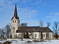
The Michaelis Church

Ruins of the order castle

primary school

manor

Alvar in Keila

Over 300 years old oak in Keila


.jpg)

Personalities
- Tarmo Leinatamm (1957–2014), Estonian conductor, politician and comedian
- Oskar Üpraus (1898–1968), Estonian national football player
Web links
- Website of the city of Keila (Estonian)
- Harjumaa County Museum of Local History (Estonian)
- SOS Children's Villages Keila (Estonian and English)
Individual evidence
- ↑ a b Statistics Estonia: Population by sex, age and place of residence after the 2017 administrative reform, 1 January. Retrieved February 17, 2019 .
- ↑ Sõpruslinnad - Keila Linnavalitsus. Retrieved June 6, 2016 .