
Jõelähtme
| Jõelähtme | |||
|
|||
| State : |
|
||
| Circle : |
|
||
| Coordinates : | 59 ° 27 ' N , 25 ° 8' E | ||
| Area : | 210 km² | ||
| Residents : | 5,279 (01.2010) | ||
| Population density : | 25 inhabitants per km² | ||
| Time zone : | EET (UTC + 2) | ||
| Website : | |||

|
|||


Jõelähtme (German: Jegelecht ) is a rural community in the Estonian district of Harju with an area of 210 km². It has 5279 inhabitants (as of January 1, 2010).
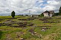
Jõelähtme is located in the north of the county, about 3 km from Tallinn . In addition to the main town Jõelähtme, the municipality includes the villages of Aruaru, Haapse, Haljava, Ihasalu, Iru , Jõesuu, Jägala, Jägala-Joa, Kaberneeme, Kallavere, Koila, Koipsi , Koogi, Kostiranna, Kostivere , Kullamäe, Liivamäe, Loo alela , Maardu, Manniva, Neeme, Nehatu, Parasmäe, Rammu , Rebala , Rohusi , Ruu, Saha , Sambu, Ülgase, Uusküla, Vandjala and Võerdla.
The area of the municipality also includes the smaller Baltic Sea islands Rammu (96.6 ha), Laiakari (0.2 ha), Allu (0.7 ha), Koipsi (33 ha), Rohusi (10.1 ha), Umbloo (0.5 ha), Põhja-Malusi (4.3 ha), Lõuna-Malusi (3.0 ha) and Vahekari (2.0 ha).
The manors of Maardu (built at the end of the 1660s in the early classical style) and Kostivere (18th century) are particularly worth seeing .
Shortly before the Jägala river flows into the Baltic Sea, there is the waterfall of the same name , the largest in Estonia.
- photos


Kalevi-Liiva
In the sand dunes of Kalevi-Liiva , mass shootings of hundreds of Jews by the German occupying forces took place on September 5, 1942 and thereafter. A memorial stone and a plaque commemorate the murders today.
Jägala concentration camp
The Jägala concentration camp was located near the village of Jägala in 1942/43 .
Web links
- Jõelähtme Municipality website (Estonian)