Kiviõli
| Kiviõli | |||
|
|||
| State : |
|
||
| Circle : |
|
||
| Founded : | 1922 | ||
| Coordinates : | 59 ° 21 ′ N , 26 ° 58 ′ E | ||
| Area : | 11.75 km² | ||
| Residents : | 5,634 (December 31, 2011) | ||
| Population density : | 479 inhabitants per km² | ||
| Time zone : | EET (UTC + 2) | ||
| Community type: | city | ||
| Mayor : | Dmitri Dmitrijev
( Keskerakond ) |
||
| Postal address : | Keskpuiestee 20 43199 Kiviõli |
||
| Website : | |||
|
|
|||
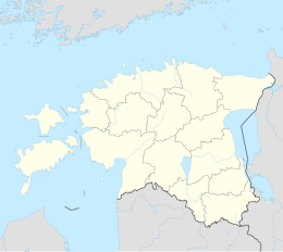
Kiviõli (in German rock oil , Russian Кивиыли Kiwiyli ) is an industrial city in the northeast of the Republic of Estonia . It is located in the Ida-Virumaa district .
Population and location
Kiviõli has 5,634 inhabitants (as of December 31, 2011). According to the 2000 census, 51.2 percent of the population of Kiviõli are Russian-speaking, 39.4 percent Estonian-speaking and 2.1% Ukrainian-speaking. As in all of Northeast Estonia, the population is falling sharply. At the end of the Soviet Union , 10,390 people still lived in Kiviõli. Today the population has almost halved.
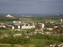
The area of the city is 11.75 km². It is divided into four boroughs and an industrial area. In the west of the city are primarily the one to two-story houses of the Varinurme workers' settlement built in the 1930s. Soviet urban planning has left its mark on industrial workers in the east.
Mountains of ash
The “landmarks” of Kiviõli are the two conical mountains of ash in the north-west of the city. They are remnants of decades of oil shale mining , to which Kiviõli - like Kohtla-Järve to the east - owes its existence. The two cones are the highest artificial mountains in the Baltic States : the 115 m high Uus tuhamägi and the 101 m Vana tuhamägi located immediately to the east . A small path leads visitors to a viewing platform at the top.
history
The history of the city is closely linked to the joint stock company Põhja Paberi- ja Puupapivabrikute AS . She explored oil shale quarrying sites during the First World War . She struck gold in the area of the village of Erra-Sala. In 1922, the first open-cast mine site of the AS Eesti Kiviõli company was put into operation. From 1925 the company AS Küttejõud mined oil shale for the Tallinn cellulose factory in open-cast mining, then from 1933 also underground.
In 1928 Kiviõli got its current name. In the 1930s, the workers' settlement grew rapidly. In 1936 the people's house ( rahvamaja ), built in the style of functionalism , was opened. In 1939 Kiviõli had about 3,000 inhabitants.
In 1931 and 1937 two large oil and gasoline factories were opened. The location at the beginning of the railway line between the Estonian capital Tallinn and the border town Narva , which was completed in the 1870s, facilitated the transport of the products.
The Second World War left Kiviõli with great damage. When the German Wehrmacht withdrew in 1944, they followed a scorched earth policy. On September 18, 1944, she set fire to all factories and tried to destroy the mines and industrial plants.
After the Soviet occupation of Estonia, Kiviõli received city rights in 1946 . From 1957 to 1991 Kiviõli belonged to the city of Kohtla-Järve . When Estonian regained independence, city rights were restored on January 10, 1991.
economy
Since 1945 the oil shale has been mined by the state-owned Soviet company Eesti Põlevkivi . 80% of the oil shale extracted is converted into electricity or heating, mainly at the Narva Electric Power Station. The rest is used for the production of special oils, gases or cement.
The number of employees in the companies fell sharply after the end of the Soviet Union. The largest employers in Kiviõli today are the special factory for oil shale products Kiviõli Keemiatööstuse OÜ and the two sewing factories AS Svarmil and AS Vezala .
environment
Due to the industrial development, Kiviõli retained major environmental damage, especially in the Soviet era. The trees died from the seeping water from the ash mountains. Phenols contaminated the Purtse river and the groundwater. The power plants spewed soot, ash, nitrogen oxides and sulfur dioxide in large quantities. Due to the decline in industry and the environmental regulations of the European Union , Kiviõli is now getting more and more of its environmental problems under control. A quiet and natural space was created on the site of the old chemical combine. The nearby lake Uljaste ( Uljaste järv ) also offers recreational opportunities .
POW camp
In Kiviõli and Küttejõu there was a POW camp 279 during the German occupation of Estonia (1941–1944) . It was also used as a transit camp for Jews before they were transported to the next murder, as well as a labor and concentration camp, including for political prisoners. After the Second World War, German prisoners of war were interned in the camp.
During the time of the Estonian SSR there was a pedestal at the site of the former camp , commemorating the victims of the National Socialist occupation of Estonia. It was replaced on June 14, 1994 by a black granite cross. The memorial today commemorates all victims of the tyranny.
people
- Maris Lauri (* 1966), politician
- Tatjana Mannima (* 1980), cross-country skier
Web links
- Official website (Estonian, Russian, English)
- Entry in Eesti Entsüklopeedia (online version)
Individual evidence
- ↑ http://www.eestigiid.ee/?CatID=48
- ↑ Indrek Rohtmets: Kultuurilooline Eestimaa. Tallinn 2004, p. 187, ISBN 9985-3-0882-4
- ↑ http://www.eestigiid.ee/?SCat=58&CatID=0&ItemID=1671
- ^ Thea Karin: Estonia. Cultural and scenic diversity in a historical borderland between east and west. Cologne 1994 (= DuMont art and landscape guide ) ISBN 3-7701-2614-9 , p. 136f. and 140


