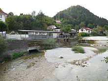
Kieferbach
|
Kieferbach Thierseer Ache, Klausbach, Klausenbach |
||
|
Schematic map of the course of the Thierseer Ache / Kieferbaches |
||
| Data | ||
| Water code | AT : 2-8-260, DE : 181994 | |
| location | Austria , Germany | |
| River system | Danube | |
| Drain over | Inn → Danube → Black Sea | |
| source | Hinterkesselboden near the original pass 47 ° 36 ′ 52 ″ N , 11 ° 58 ′ 46 ″ E |
|
| Source height | 1221 m above sea level A. | |
| muzzle | near Kiefersfelden in the Inn Coordinates: 47 ° 36 '22 " N , 12 ° 12' 7" E 47 ° 36 '22 " N , 12 ° 12' 7" E |
|
| Mouth height | 478 m above sea level NN | |
| Height difference | 743 m | |
| Bottom slope | 31 ‰ | |
| length | 23.9 km | |
| Catchment area | 123.52 km² | |
| Discharge at the level Bleyerbrücke A Eo : 116 km² Location: 4.1 km above the mouth |
NNQ (02/04/1963) MNQ 1951–2006 MQ 1951–2006 Mq 1951–2006 MHQ 1951–2006 HHQ (07/20/1963) |
260 l / s 860 l / s 3.44 m³ / s 29.7 l / (s km²) 52.3 m³ / s 115 m³ / s |
| Left tributaries | Trockenbach, Trainsbach, Gießenbach | |
| Right tributaries | Stallenbach, Glemmbach, Tiefenbach, outflow of the Thiersee , outflow of the Hechtsee | |
| Communities | Thiersee , Kiefersfelden , Bayrischzell | |

The Kieferbach , just called Ache or Klausbach in the upper reaches , Thierseer Ache in the middle and also Klausenbach in the lower reaches , is an approximately 24 km long, left or western tributary of the Inn in the Northern Limestone Alps in Austria and Germany .
Name interpretation
Klausenbach or Klausbach comes from "klausen". In addition, the timber transport from the surrounding forests used to be handled by damming the stream, which is still partially visible in the Glemmtal Gorge. The grammatically correct spelling Thierseeer Ache is wrong.
course
The river rises in Tyrol as Klausbach im Hinterkesselboden from several small, occasionally dry creeks on the north side of the Schönfeldjoch near the Ursprung Pass , flows as Thierseer Ache in the Thierseetal through the municipality of Thiersee, past the cement quarry in Wachtl over the border to Bavaria . In the area from the state border to the Gießenbach estuary, the body of water has the two official names Kieferbach and Klausenbach . After the tributary of the Gießenbach on the left , the Wachtl-Express -Bahn and the Thierseestraße follow the course of the river through the Klausenbachtal towards Kiefersfelden . About halfway the Hechtsee drain flows to the right. The river then flows through the village as a Kieferbach and finally flows into the Inn in the Unteriefer district .
The Thierseer Ache and the Glemmbach flowing into it form the border between the Bavarian Prealps in the north and the Brandenberg Alps in the south.
use
In the middle of Kiefersfelden there is a weir on the right bank and then a hydropower screw .
ecology
The course of the Thierseer Ache is mostly natural or close to nature. It has water quality class II in Tyrol (as of 2005).
Web links
Individual evidence
- ↑ a b c TIRIS - Tyrolean regional planning and information system
- ↑ Directory of brook and river areas in Bavaria - Inn river area, page 2 of the Bavarian State Office for the Environment, as of 2016 (PDF; 2.8 MB)
- ^ German Hydrological Yearbook Danube Region 2006 Bavarian State Office for the Environment, p. 228, accessed on October 4, 2017, at: bestellen.bayern.de (PDF, German, 24.2 MB).
- ↑ Federal Ministry of Agriculture, Forestry, Environment and Water Management (ed.): Saprobiological water quality of the flowing waters of Austria. As of 2005. ( PDF; 1 MB ( Memento of the original from December 22, 2015 in the Internet Archive ) Info: The archive link has been inserted automatically and has not yet been checked. Please check the original and archive link according to the instructions and then remove this note. )


