
Gufferthütte
| Gufferthütte DAV hut category I |
||
|---|---|---|
 Gufferthütte |
||
| location | Brandenberger Rossalm; Tyrol , Austria ; Valley location: Achenkirch , Wildbad Kreuth | |
| Mountain range | Bavarian Prealps | |
| Geographical location: | 47 ° 34 '53.5 " N , 11 ° 47' 58" E | |
| Altitude | 1465 m above sea level A. | |
|
||
| builder | Munich section of the DuÖAV | |
| owner | DAV - Kaufering section | |
| Built | 1926 | |
| Construction type | hut | |
| Development | Forest road | |
| Usual opening times | May – October | |
| accommodation | 57 beds | |
| Winter room | 6 bearings | |
| Web link | gufferthuette.at | |
| Hut directory | ÖAV DAV | |

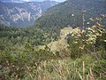
The Gufferthütte (formerly also Ludwig-Aschenbrenner-Hütte ) is an Alpine Club hut of the Kaufering section of the German Alpine Club at 1,465 m above sea level. A. in the Bavarian Prealps on the south side of the Blauberge and thus already in the Austrian state of Tyrol . The Brandenberger Alps (Rofan Mountains) join in a depression further south .
Characteristic

The Gufferthütte is located about 600 meters south of the German-Austrian border and near the Bavarian Wildalm . The section of the ring of the Buy DAV supervised hut is a shelter of the cabin category I and has 57 accommodation places on during the summer season, 20 and room 37 Dormitory. The winter room of the hut has 6 beds and is freely accessible (price: € 10 per person / night for AV members). The hut is supplied via a forest path that branches off the road from Achenkirch to Steinberg am Rofan from the Köglboden car park and first leads through the Ampelsbach valley , then later through the Filzmoosbach valley to the hut.
history
The Gufferthütte was built by the Munich section of the then DuÖAV and named after the hut's local mountain, the 2194 m high Guffert , when it was inaugurated in June 1926 . After the hut was destroyed by fire in the spring of 1957, it was rebuilt on the foundation walls the following year. In 1960 the hut was renamed Ludwig-Aschenbrenner- Hütte by the Munich Section to honor the services of its functionary Ludwig Aschenbrenner. After the hut was sold in 1997 by the Munich Section to the Kaufering Section of the DAV, the DAV was renamed so that the Gufferthütte now bears its original name again. From 1998 to 2003 the hut was extensively renovated by the new owner's section.
Ascents


- From the northwest from the Kreuther valley
- From the Schwaigeralm car park ( 802 m ) at Wildbad Kreuth eastwards through the Sagenbach valley and the Langenau, at the Steinernes Kreuz ( 884 m ) waypoint , turning south into the valley of the Lohgartengraben, there on the partially exposed hiking trail BB1 to the pasture area of the dilapidated Bayrbachalm ( 1209 m ) up and from there on path BB2 over the Wildalmsattel ( 1499 m ) to the hut, in 3 hours
- From Kreuth ( 787 m ) via the Siebenhütten snack station ( 836 m ), the Wenigberger Jagdhütte and the Halserspitze ( 1861 m ), in 4 hours
- From the Schwaigeralm car park ( 802 m ) at Wildbad Kreuth, head east through the Sagenbach valley and the Langenau to the Langenaualm ( 960 m ), then past the managed Bayralm and immediately on the Langeneckberg to the pasture area of the dilapidated Bayrbachalm ( 1209 m ), from there southwards on path BB2 over the Wildalmsattel ( 1499 m ) to the hut, in 4.5 hours
- From Kreuth ( 787 m ) via the Siebenhütten snack bar ( 836 m ), the Wolfsschlucht, the Blaubergalm and the Schönleitenalm ( 1480 m ), in 5 hours
- From Kreuth ( 787 m ) over the Geißalm, the Schildensteinsattel ( 1530 m ) and the Blaubergalm, in 6 hours
- From the southwest from the Achental
- From the Köglboden car park ( 957 m ) on the road from Achenkirch to Steinberg through the Ampersbach valley and the Filzmoosbach valley, in 2¼ hours
Adjacent huts
The neighboring huts of the Gufferthütte are:
- the Erfurter Hütte ( 1834 m ) in 9 hours
- the Tegernseer Hütte ( 1650 m ) in 7 hours
Summit tours
- Halserspitz , height 1862 m , in 1¼ hours
- Schneidjoch , altitude 1810 m , in 1 hours
- Guffert , altitude 2194 m , in 3½ hours
Other tours
- Etruscan inscriptions, altitude 1500 m , in ¾ hours
- Abendstein (climbing rock), altitude 1650 m , in ¾ hours
photos

Gufferthütte terrace

Aerial view of Gufferthütte

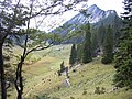
The Langenaualm

The managed Bayralm
The pasture area of the dilapidated Bayrbachalm
The Bavarian Wildalm


Literature and maps
- Die Alpenvereinshütten Volume 1: Eastern Alps , page 83. Bergverlag Rother GmbH, Munich 2005. ISBN 3-7633-8073-6
- Alpine Club Map (1: 25,000), BY14 Mangfall Mountains South - Guffert, Unnütz, Juifen
- Alpine club map (1: 25,000), BY13a Mangfall Mountains - Kreuth and surroundings