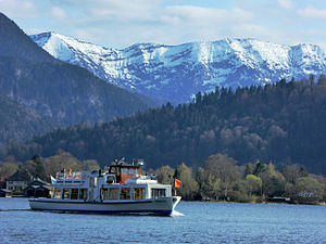
Blue mountains
| Blue mountains | ||
|---|---|---|
|
Blauberge with Halserspitz (left) from Tegernsee |
||
| height |
1862 m above sea level NN 1863 m above sea level A. |
|
| location | Bavaria , Germany and Tyrol , Austria | |
| Mountains | Mangfall Mountains , Bavarian Prealps | |
| Dominance | 4.7 km → Guffert | |
| Notch height | 454 m ↓ Brandenberger Rossalm | |
| Coordinates | 47 ° 35 '29 " N , 11 ° 46' 53" E | |
|
|
||
The Blauberge are a mountain range in the Bavarian Prealps on the border between Bavaria and Tyrol . The highest peak is the Halserspitze , also called Halserspitz , with a height of 1863 m above sea level. A.
Location and surroundings
The Blauberge are part of the Upper Bavarian Mangfall Mountains , more precisely the Tegernsee Mountains and are located about eleven kilometers south of the Tegernsee . The ridge of the Blauberge, which runs about four kilometers in a west-east direction, forms the border between Austria in the south and Germany in the north. The Brandenberg Alps extend south to the Inn Valley . In the north are the Wolfsschlucht and about four kilometers away is the former spa town of Wildbad Kreuth . The neighboring mountain in the west is the 1613 m high Schildenstein , which is partly also counted among the Blue Mountains. The massif consists of six peaks from west to east, or seven peaks including the Schildenstein:
![]() Map with all coordinates: OSM | WikiMap
Map with all coordinates: OSM | WikiMap
- Schildenstein ( 1613 m , 47 ° 36 ′ N , 11 ° 43 ′ E )
- Predigtstuhl ( 1562 m , 47 ° 35 ′ N , 11 ° 44 ′ E )
- Wichtlplatte ( 1765 m , 47 ° 35 ' N , 11 ° 45' O )
- Blaubergschneid ( 1787 m , 47 ° 35 ′ N , 11 ° 45 ′ E )
- Blaubergkopf ( 1787 m , 47 ° 35 ′ N , 11 ° 46 ′ E )
- Karspitz ( 1800 m , 47 ° 35 ′ N , 11 ° 47 ′ E )
- Halserspitz ( 1862 m , 47 ° 35 ′ N , 11 ° 47 ′ E )
With its 1,862 m, the Halserspitz is not only the highest peak of the Blauberge, but of the entire Tegernsee Mountains. The southern flank of the Blauberge is overgrown with mountain pines up to the height of the ridge , while the much steeper northern side has a more rocky character. The Hofbauernweißach with its tributaries drains the entire north side of the Blauberge. In the east, beyond the Bavarian Wildalm, the Wilder Lochberg ridge joins the Schattlahnerkopf .
Bases and paths
An important base is the Gufferthütte ( 1475 m ) of the Kaufering Alpine Club section , just southeast of the Halserspitze , which is managed in summer and offers overnight accommodation. Not far from there is the self-catering hut Bayerische Wildalm of the Oberland section of the German Alpine Club. The Blaubergalm ( 1540 m ) directly below the Predigtstuhl further west is also easily managed .
A marked hiking trail leads over the ridge of the Blauberge, which allows you to traverse the entire massif. The starting point of this popular but long circular hike is usually Wildbad Kreuth. The ascent from there over the Siebenhüttenalm and through the Wolfsschlucht to the saddle between Schildenstein and Predigtstuhl is in places secured by wire rope . Further approaches are possible from the Gufferthütte or from Achenwald . The east end of the Blauberge can be reached from the Gufferthütte or from Wildbad Kreuth (via the Wenigberghütte or the Bayrbachalm). A time of around eight hours is specified for the entire lap.
Literature and map
- Wolfgang and Gerlinde Zimmermann: Alpine Club Guide Bayerische Voralpen-Ost , Bergverlag Rother , Munich 1980, ISBN 3-7633-1103-3
- Georg Hohenester, Stefan Winter: Bayerns Berge , Bergverlag Rother, Munich 2009, ISBN 978-3-7633-3041-6
- Alpine Club Map 1: 25,000, sheet BY 13, Mangfall Mountains West, Tegernsee, Hirschberg
Web links
- Blauberge - Halserspitze on Summitpost.org
Individual evidence
- ↑ Federal Office for Metrology and Surveying : Austrian Map 1: 50,000, AMAP Online , accessed on November 2, 2010
- ↑ Federal Office for Cartography and Geodesy , State Office for Surveying and Geoinformation Bavaria : Digital Topographic Map 1:50 000, BayernViewer ( Memento of the original from October 2, 2011 in the Internet Archive ) Info: The archive link was automatically inserted and not yet checked. Please check the original and archive link according to the instructions and then remove this notice. , accessed November 2, 2010
- ↑ Blauberge - Halserspitze on Summitpost.org, accessed on November 2, 2010
- ↑ Heinrich Bauregger: hiking in the Tegernsee and Schliersee mountains . 50 selected tours for the areas around Bad Feilnbach, Brannenburg, Kiefersfelden, Bayrischzell, Schliersee, Gmund, Tegernsee, Rottach-Egern, Kreuth and Bad Wiessee. Rother, Munich 1999, ISBN 978-3-7633-4258-7 , pp. 118 ( Google Books [accessed November 2, 2010]).


