Parseier point
| Parseier point | ||
|---|---|---|
|
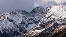
View from Gatschkopf to the south face, east ridge and north-east face of the Parseierspitze, on the left the remains of the Grinner Ferners |
||
| height | 3036 m above sea level A. | |
| location | Tyrol , Austria | |
| Mountains | Lechtal Alps | |
| Dominance | 10.3 km → Hoher Riffler | |
| Notch height | 1243 m ↓ Arlberg Pass | |
| Coordinates | 47 ° 10 '28 " N , 10 ° 28' 42" E | |
|
|
||
| Type | Rock peaks | |
| rock | Marl , radiolarite , limestone | |
| Age of the rock | law | |
| First ascent | 1869 by Josef Anton Specht , led by Peter Siess | |
| Normal way | From Grins over the Augsburger Hütte, the Gatschkopf, then over the southeast flank and Schrofen to the summit ( UIAA II) | |
The Parseierspitze is with a height of 3036 m above sea level. A. the highest peak in the Northern Limestone Alps and their only three-thousand-meter peak . The peak in the Austrian state of Tyrol is the main peak of the Lechtal Alps . It was first climbed on August 23, 1869 by Josef Anton Specht and the mountain guide Peter Siess from Grins in the Stanzer Valley .
Surroundings
The Parseierspitze is about 7 kilometers as the crow flies west-northwest above Landeck am Inn . Neighboring mountains to the north are the three see heads ( Vorderer, Mittlerer, Hinterer Seekopf , up to 2718 m), immediately to the east is the Gatschkopf (2945 m), to the south the Bockgartenspitzen (up to 2941 m) and to the west the Grießmuttekopf with 2807 meters.
geology
A special feature of the Parseierspitze is a conspicuous greenish-reddish band of rock a little below the summit. These are radiolarites that emerge from the surrounding brownish marl . The radiolarites and a layer of aptych limestone from the Upper Jurassic placed on the summit prevent excessive erosion due to their weathering resistance , so that the mountain retains its unusual height for the surroundings. In the cirque at the foot of the south face are the remains of a glacier , the Grinner Ferners . Another small firn field , the Parseierferner , is located southwest of the tip.
Support points and routes for ascent
According to literature, the Parseierspitze was first climbed in 1869 by Josef Anton Specht and Peter Siess, although it can be assumed that locals had already reached the summit before that. From the Lechtal side, the peak was first walked by Anselm Klotz in 1875 .
The Augsburger Hütte at 2289 meters above sea level usually serves as a base for an ascent . It can be reached in 3½ hours from Grins in the Stanzer Valley. The easiest route to the Parseierspitze leads from there in a good three hours, initially over a section of the Augsburger Höhenweg through the Gasill Gorge into the cirque south of the summit, in which the ice field of the Grinner Ferner is embedded. This cirque leads to the entrance to the south wall, which is roughly in the middle of the wall and is marked with a red dot. The route through the south face to the summit is marked, but almost all of it is climbing terrain in the I and in some places in the II level of difficulty . In addition, the route is because of loose rock rockfall . As an alternative to the via ferrata-like route through the Gasill Gorge, you can also cross the Gatschkopf from the Augsburger Hütte in order to reach the cirque south of the summit via the Patrolscharte .
Another base for climbing the Parseierspitze is the Memminger Hut to the north at an altitude of 2242 meters. Via the Spiehlerweg you get south to the Patrolscharte, over this into the cirque south of the summit and from there as described above through the south wall to the summit.
From the Patrolscharte you can also get directly to the summit via the east ridge. The climbing difficulties on this route are only in the upper II and III. Difficulty level, but the rock is extremely brittle and the lower part is extremely exposed .
As a spring ski tour, it is possible to climb from Zams via the Zammer Loch and the Patrolscharte.
Literature and map
- Heinz Groth, Rudolf Wutscher: Area guide Lechtal Alps . Bergverlag Rother , 6th edition, Munich 1996, ISBN 978-3-7633-3261-8
- Dieter Seibert: Alpine Club Guide alpine, Lechtal Alps . Bergverlag Rother, Munich 2002, ISBN 978-3-7633-1268-9
- Alpine club map 1: 25,000, sheet 3/3, Lechtal Alps, Parseierspitze .
Individual evidence
- ↑ Yearbook of the Austrian Alpine Association, Volume VI, Vienna 1870, p. 298
- ^ Raimund von Klebelsberg : Geologie von Tirol , Berlin 1935, p. 82
- ↑ Carl Deutsch in Eduard Richter : The Development of the Eastern Alps , Volume I, Berlin 1893, pp. 106 ff.


