High Riffler (Verwall)
| High Riffler | ||
|---|---|---|
|
High Riffler from the north |
||
| height | 3168 m above sea level A. | |
| location | Tyrol , Austria | |
| Mountains | Verwall | |
| Dominance | 23.8 km → Stammerspitze | |
| Notch height | 1326 m ↓ Zeinisjoch | |
| Coordinates | 47 ° 6 '58 " N , 10 ° 22' 16" E | |
|
|
||
| rock | Gneiss | |
| First ascent | 1864 by Josef Anton Specht and Franz Pöll | |
| Normal way | from the Edmund-Graf-Hütte through the west flank, to the south summit, marked trail, transition to the north summit II | |
| particularities | highest mountain in the Verwall group | |
The Hohe Riffler is with a height of 3168 m above sea level. A. the highest peak of the Verwall group and is located in the far east of the area, in the Austrian state of Tyrol .
Location and landscape
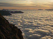
The mountain, which can be seen from afar, rises above its immediate surroundings and therefore offers a comprehensive panorama over the Verwall Group in the west, the Allgäu and Lechtal Alps in the north, the Zugspitze and Mieminger Mountains in the northeast, Karwendel in the east, the Ötztal Alps (with Views of the Stubai Alps , e.g., Wardrobe and Zuckerhütl ) in the east, the Ortler group in the southeast, the Samnaun group in the south and the Silvretta in the southwest. In addition, it offers a deep view of the adjacent valleys, from which the Hohe Riffler stands out as the dominant mountain figure. You can also see the Ortler and Bernina mountains. When visibility is very good, the view extends as far as the Bernese and Glarus Alps and a maximum of 232 km away Weisshorn in the Valais Alps . A marked path leads to the south summit, on which there is also a summit book. In order to reach the summit via this normal route, no special climbing skills are required. That's why the Hohe Riffler is an easy three-thousand-meter peak. The transition to the north summit (with a cross) two meters higher and only 30 meters away is only possible by climbing and is therefore reserved for experienced alpinists. The Kleine Riffler (3,014 m) towering over the Pettneuer Ferner can be reached with a 5-minute detour from the normal route.
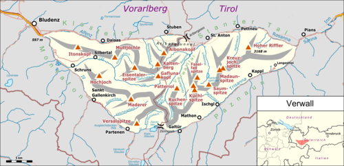
Location of the Hohe Riffler in Verwall |
Mösli landscape protection area
The Flirscher Ferner at the eastern foot of the summit structure of the Hohen Riffler and the Scheibenkopf ( 2538 m above sea level ) to the east above the Gampernunalpe (municipality of Flirsch ) form the Mösli landscape protection area . The protected area extends to the summit ridge (north ridge to Gauderkopf , west ridge towards Gampernun).
Development
Due to its convenient location in terms of traffic and its dominant appearance between the Paznaun ( Trisannatal ) in the southeast and the Stanzer Tal in the north, the Riffler has been attractive to tourists since the middle of the 19th century. In 1864 Josef Anton Specht and the mountain guide Franz Pöll climbed the mountain from Pettneu . Their route took them south through the Malfontal and then east through a side valley in which the Edmund-Graf-Hütte has been located since 1885 . First they crossed the Blankahorn (3129 m) and then reached the western summit of the Riffler via the then still extensive Pettneuer Ferner . On September 4, 1867, Anton von Ruthner followed with a Paznaun chamois hunter named Lipp from Langesthei across the south side.
Today's base for the ice-free ascent via the normal route is the Edmund-Graf-Hütte ( 2375 m above sea level ) above Pettneu am Arlberg in the Stanzertal. It can be reached in three hours from Pettneu. From here you can walk to the south summit in a good two hours if the conditions are favorable. From the south summit, the northern main summit can be reached in 15 minutes. According to the literature, the crossing between the peaks has the UIAA difficulty level II .
The mountain is a popular destination for ski mountaineers, especially in late winter and spring. Usually only the lower southern summit is climbed.
Literature and map
- Peter Pindur, Roland Luzian, Andreas Weiskopf: Alpenvereinsführer Verwallgruppe , Munich 2005, ISBN 3-7633-1251-X
- Map: Verlag Freytag & Berndt, hiking map 1: 50,000, Arlberg, Paznaun, Verwall group
Web links
- Description and pictures of a ski tour on the Hohen Riffler
- Hoher Riffler (Verwall) on Peakbagger.com (English)
Individual evidence
- ↑ udeuschle.de
- ↑ promulgated LGBl. 18/2010 6th piece , March 30, 2010; Map ( memento from December 15, 2012 in the web archive archive.today ), tirol.gv.at/tiris
- ^ W. Strauss in: Eduard Richter : The development of the Eastern Alps , Volume II, Berlin 1894, p. 57 f.


