Zuckerhütl
| Zuckerhütl | ||
|---|---|---|
|
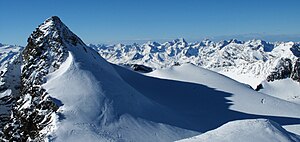
The Zuckerhütl, seen from the Wilder Pfaff in mid-May |
||
| height | 3507 m above sea level A. | |
| location | Tyrol , Austria | |
| Mountains | Stubai Alps | |
| Dominance | 19.5 km → Mittl. Ramolkogel | |
| Notch height | 1033 m ↓ Timmelsjoch | |
| Coordinates | 46 ° 57 '52 " N , 11 ° 9' 13" E | |
|
|
||
| First ascent | 1863 by Josef Anton Specht with guide Alois Tanzer | |
| Normal way | Alpine tour (glaciated) | |
|
Zuckerhütl in mid-November 2009, seen from the Wilder Pfaff. |
||
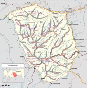
The Zuckerhütl is at 3507 m above sea level. A. the highest mountain in the Stubai Alps , Tyrol . It is located entirely in North Tyrol near the border with South Tyrol .
The Zuckerhütl was named after its graceful shape that is visible from the entrance to the Stubai Valley . From the east it appears as a bold snow horn with the character of a sugar loaf, from the west it appears rocky, raw and forbidding. The north side, covered by ice and firn, is increasingly visible through the glacier retreat.
West of the Zuckerhütl is the Pfaffenschneide ( 3498 m ), the southeastern neighbor of the Zuckerhütl is the Wilde Pfaff ( 3456 m ), over which it is often climbed - this is the route via the Nürnberger Hütte and the Müllerhütte . There are also frequent ascent routes via the Hildesheimer Hütte , the Sulzenauhütte (risk of falling rocks) and from the Stubai Glacier ski area . From all these starting points, the summit structure is usually climbed via the east ridge from the Pfaffensattel ( 3344 m ), the saddle between Zuckerhütl and Wilder Pfaff, with difficulty level I. A variant with difficulty level II leads from the east ridge to the south flank. Further, less frequently used climbs run through the south face (IV), over the Pfaffenschneide and through the 60 ° steep, icy north face.
Long before there were regular surveys, the Habicht ( 3277 m ) was thought to be the highest mountain in the Stubai Alps due to its exposed location .
The film Summit Cross from 1948, which is shown from time to time in Fulpmes, is about the first summit cross on the Zuckerhütl (built in 1947) . In addition to the story of its creation, the film also includes spectacular images during a storm in the Sulzenaufern icefall . In 2001 the cross fell over and lay damaged on the floor until a newspaper letter to the editor drew attention to this condition. The mountain guides in Neustift then took the initiative and erected a completely new summit cross.
literature
- Walter Klier : Alpine Club Guide Stubai Alps Alpine . 13th edition. Bergverlag Rother , Munich 2006, ISBN 3-7633-1271-4 . , Pp. 334-336
- Hanspaul Menara : The most beautiful 3000m peaks in South Tyrol. 70 worthwhile alpine tours. Athesia, Bozen 2014, ISBN 978-88-8266-911-9
Web links
- Zuckerhütl from the Stubai Glacier on alpenverein aktiv.com (German)
- Zuckerhütl on Peakbagger.com (English)
Individual evidence
- ↑ Eberhard Jurgalski : Complete table of summits in the Alps separated by 590 meters of re-ascent , December 12, 2008.
- ^ Federal Office for Metrology and Surveying Austria: Zuckerhütl on the Austrian Map online (Austrian map 1: 50,000) .
- ^ Kunz, Wolfgang: Summit crosses in Tyrol. A cultural history with a contemporary reference. Vienna Cologne Weimar 2012, p. 69
- ↑ Zuckerhütl , Becherhaus.com, accessed on September 29, 2012


