Timmelsjoch
| Timmelsjoch / Passo del Rombo | |||
|---|---|---|---|
|
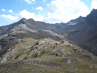
The crest of the Timmelsjoch pass from the north |
|||
| Compass direction | northwest | Southeast | |
| Pass height | 2474 m above sea level A. | ||
| Valley: Country: |
Ötztal Tirol A |
Passeier BZ I |
|
| Watershed | Timmelsbach → Gurgler Ache → Ötztaler Ache → Inn → Danube | Passer → Etsch | |
| Valley locations | Sölden , Zwieselstein | St. Leonhard in Passeier , Rabenstein | |
| expansion | Ötztalstrasse B 186 |
|
|
| Built | 1955-1959 | 1933 | |
| Winter and night closure |
Mid-October to mid-June 8 pm-7am |
||
| Mountains |
Stubai Alps (northeast) Ötztal Alps (southwest) |
||
| profile | |||
| Ø pitch | 4.8% (1004 m / 21 km) | 6.4% (1784 m / 28 km) | |
| map | |||
|
|
|||
| Coordinates | 46 ° 54 '19 " N , 11 ° 5' 51" E | ||
The Timmelsjoch , or Timmel for short ( Italian Passo del Rombo ), is a border pass between Austria (province of Tyrol ) and Italy (province of South Tyrol ) and lies at an altitude of 2474 m above sea level. A. The yoke is part of the European watershed and the only passable passage on the main Alpine ridge between Reschen and Brenner . It connects the Ötztal with Passeier and separates the Ötztal Alps from the Stubai Alps . Since the Treaty of Saint-Germain came into force in 1920, the border between Italy and Austria has run across the Timmelsjoch . The South Tyrolean parts of the pass belong to the Texel Group Nature Park .
height
Various information is circulating about the height of the Timmelsjoch. The official Austrian map estimates the transition at 2,474 m , the South Tyrolean GIS Geobrowser records an altitude of 2,472 m . Basically, all newer map series show the Timmelsjoch between the 2470 m and 2480 m contour lines . In contrast, the road sign on the top of the pass and the website of the operating company announce a markedly different specification at 2509 m .
Surname
The word Timmel is traced back to the old Rhaeto-Romanic word tömbl , which denoted a small hill, which suggests that the pass has been used since ancient times. In Latin, the word tumulus for a burial mound still reminds of this. Admittedly, the Timmelsjoch pass itself is not meant with the designation "small hill", rather the name refers to the round rubble bumps formed by the glacier , which still line the entire Timmelsjochweg today.
The Italian name Passo del Rombo means "pass of the roar, thunder" and is more recent.
history
The first settlers from Passeier advanced into the inner Ötztal via the Timmelsjoch. In the Middle Ages it formed the southern border of the county in the Upper Inn Valley and the original parish of Silz . Later the border of the Petersberg court near Silz ran here. The pass was mentioned in a document as early as 1241 as "Thymels" . In 1320 a mule track was laid out. It was a trade route early on, and the merchant families Fugger and Welser also used it. Around 1770 the names "Timbl Ioch" and "Passeyrergericht Alpe Timbls" are attested. In 1897 the Tyrolean state parliament decided to build a road across the Timmel, but other projects were brought forward.
As a result of the peace treaty of St. Germain , the border between Italy and Austria ran across the yoke from 1920 and all official border traffic was prohibited. In the last weeks of the Second World War in April and May 1945, numerous soldiers of the German Wehrmacht returned from Italy to the Ötztal.
The Timmelsjoch Museum was opened in 2010 . The South Tyrolean architect Werner Tscholl designed additional architectural elements of a sculptural nature, which are intended to underline the function of communication and connection.
Timmelsjoch High Alpine Road
The plan of a road over the Timmelsjoch was taken up again soon after the Second World War. The pioneer was the then Provincial Councilor and later Governor Eduard Wallnöfer , himself a native of South Tyrol.
The north ramp was built between 1955 and 1959, at a cost of 28 million schillings at the time (roughly equivalent to the current equivalent of 14 million euros ).
The south ramp from Passeier up was built under Benito Mussolini from 1933 up to two kilometers from the yoke as a military road in order to be able to use it for an offensive against Austria in the event of war, but with the completion of the Berlin-Rome axis with the meeting of Mussolini and Hitler the work stopped. It took until September 15, 1968, until the road connection in both directions could be officially opened.
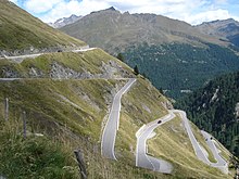
The street is usually open from 7 a.m. to 8 p.m. from mid-June to mid-October. The road, which has been freed from truck traffic, is important not only as a transport link but also primarily as an excursion road for cars and motorcycles. The road is also popular with racing cyclists , as it is one of the longest continuous inclines in the Alps. The almost 1800 vertical meters , spread over a distance of approx. 30 km from St. Leonhard to the top of the pass and the almost 800 vertical meter long final ascent in serpentines represent a sporting challenge. The Ötztal Cycle Marathon takes place every year in August , with the Timmelsjoch being a special one Challenge, as it is the last ascent after the participants - mostly hobby drivers - have already driven from Sölden via Kühtai , Innsbruck , Brenner Pass and Jaufen Pass . In 1988 the Giro d'Italia led in one stage from Merano via the Timmelsjoch to Innsbruck.
At 2,474 m , the Timmelsjoch is Austria's highest road border crossing. Behind the tourist town of Hochgurgl is the toll station for the toll part of the road. The toll for the Italian side is collected together with the toll for the Austrian side. The road on the North Tyrolean side is operated by the Timmelsjoch - Hochalpenstraße - Aktiengesellschaft, founded on August 20, 1955.
In the Top Mountain Crosspoint building with an area of 6060 m², the valley station of the Kirchenkarbahn I cable car system , a service restaurant with terrace (280 indoor and 380 outdoor seats), the toll station of the Timmelsjoch High Alpine Road and the highest motorcycle museum in Europe ( Top Mountain Motorcycle Museum ). Above the top of the pass there is a viewing platform designed by the architect Werner Tscholl and the engineer Siegfried Pohl.
Toll booth in Hochgurgl
literature
- Günther Niederwanger: Stone Age finds on the Timmelsjoch . In: The Sciliar . tape 81 , 2007, p. 32-37 .
- Manfred Schwarz, Irene Prugger, Stefan Pertl: Across the Timmelsjoch. From the dangerous mule track to the dream road in the Alps . Athesia-Tappeiner Verlag, Bozen 2018, ISBN 978-88-6839-268-0 .
Movies
- Timmelsjoch - When borders connect (2018): Documentary by Philipp J. Pamer
Web links
Individual evidence
- ↑ a b c Austrian Map online - a BEV service
- ^ Austrian map 1: 50,000
- ↑ Geobrowser
- ^ Steffan Bruns: Alpine passes. History of the alpine pass crossings. From the Inn to Lake Garda . 1st edition. tape 3 . L. Staackmann Verlag, Munich 2010, ISBN 978-3-88675-273-7 , p. 80 .
- ^ Egon Kühebacher : The place names of South Tyrol and their history. Volume 2: The historically grown names of the valleys, rivers, streams and lakes. Athesia, Bozen 1995, ISBN 88-7014-827-0 , pp. 330-331.
- ↑ Timmelsjoch project
- ↑ Museumstrasse 5, 6020 Innsbruck, company register number: FN 32996, structure and balance sheet of Timmelsjoch-Hochalpenstrasse-Aktiengesellschaft 2012 (PDF), main shareholder: Hochgurgler Lift-Gesellschaft mbH & Co. KG with 68.57% shares.
- ↑ Top Mountain Crosspoint , website Top Mountain Crosspoint.
- ↑ baunetzwissen.de


