
Birkfelder Gschaid
| Birkfelder Gschaid | |||
|---|---|---|---|
 Birkfelder Gschaid from the descent from Zeiseleck |
|||
| Compass direction | northwest | Southeast | |
| Pass height | 807 m above sea level A. | ||
| state | Styria , Austria | ||
| Watershed | R. Quellbach | Pöllau safeners | |
| Valley locations | Gschaid near Birkfeld | Pöllau | |
| expansion | Pass road | ||
| Mountains | Edge mountains east of the Mur | ||
| profile | |||
| Ø pitch | 4.8% (244 m / 5.05 km) | 4.2% (362 m / 8.65 km) | |
| Map (Styria) | |||
|
|||
| Coordinates | 47 ° 20 '24 " N , 15 ° 44' 45" E | ||

The Birkfelder Gschaid is 807 m above sea level. A. high pass in Styria ( Austria ) and leads from the Feistritztal into the valley of the Pöllauer Safen . The Gschaid lies between the Rabenwaldkogel ( 1280 m ) in the south and the Zeiseleck ( 1078 m ) in the northeast.
The state road L448 leads over the pass from Gschaid near Birkfeld to Obersaifen and on to Pöllau . The pass road is 13.7 kilometers long. The highest point at 807 meters is at km 5.0 when coming from Birkfeld. The road joins the L406 near Pöllau.
On the top of the pass are a farm, a wayside shrine and a summer linden tree ( Tilia platyphyllos ), which is protected as a natural monument. A second linden tree, which was also protected as a natural monument, was felled in 2010 after the farm next to it burned down.
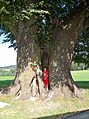
The more northerly of the two linden trees 2007 ...

... and 2010

Signpost at the top of the pass

The southern of the two linden trees
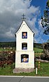
Wayside shrine


Web links
Individual evidence
- ↑ ÖK50 in www.austrianmap.at , Federal Office for Metrology and Surveying Austria, Austrian map, scale 1: 50,000.
- ^ GIS Styria. Retrieved March 2, 2019 .
Ahorn • Alpl • Ammer • Annaberg • Arlberg • Ascher • Bieler • Birkfelder • Boding • Brenner • Buchauer • Buchener • Dientner • Dürrholzer • Eibegg • Erb • Eisental • Faschina • Feistritz • Fern • Filzen • Flattnitz • Flexen • Forsthof • Furka • Fuscher • Gaberl • Gaden wide • Gailberg • Gangleit • Geiseben • Gerichtsberg • Gerlos • Geschriebenstein • Goller • Grießen • Griffner • Large Kripp • Grubberg • Grünbacher • Gschuett • Hafner • Hahntenn • neck • Haselrast • Hebalm • stallion • Hengstl • Hiaslegg • Hirschegger • Hochegger • Hochrindl • Hochtannberg • Hochtor • Holzleiten • Iselsberg • Josefsberg • Kaiserauer • Cold Kuchl • Kartitscher • Katsch • Kernhofer • Kerschbaumer • Klachauer • Klamm • Klamml • Small Kripp • Klippitz • Klostertaler • Kraxen • Kreuth • Kreuzberg • Kühtai • Lahn • Lienbach • Loibl • Losen • Luft • Mendling • Michelbühel • Moarigraben • Nassfeld • Neumarkter • Niederalpl • Norberts • Nöring • Obdacher • Oberjoch • Och • Pack • Paulitsch • Perchauer • Pfaffen • Pfarralm • Pielachtaler • Piller • Plöcken • Pogusch • Pölshals • Pötschen • Präbichl • Prebersattel • Preiner • Pretal • Promau • Pyhrn • Radl • Radling • Radstädter • Radstatt • Rams • Raneck • Rechberg • Rieder • Rohrer • Sattler • Saurüssel • Schaida • Schanz • Scharflinger • Schiestel • Schober • Schönfeld • Schwarze Sau • Schwarzenbichl • Seeberg • Seefelder • Semmering • Kleiner Semmering • Sieggraben • Silzer • Soboth • Summer • Staller • Styrian Seeberg • Straßegg • Sölk • Thurn • Timmels • Triebener Tauern • Turracher • Origin • Wechsel • Weinebene • Weißenbacher • Wagrainer • Windische • Wurzen • Zellerrain