
Schanzsattel
| Schanzsattel / On the Schanz | |||
|---|---|---|---|
 View from the old pass to the west to the Schanzwirt |
|||
| Compass direction | west | east | |
| Pass height | 1171 m above sea level A. | ||
| state | Styria | ||
| Watershed | Stanzbach → Mürz → Mur → Drau → Danube → Black Sea | Waisenbach → Feistritz → Lafnitz → Raab → Danube | |
| Valley locations | Kindberg , Stanz im Mürz Valley | Fischbach | |
| expansion | State road L114 | ||
| Mountains | Fischbach Alps | ||
| profile | |||
| Ø pitch | 5.2% (502 m / 9.7 km) | 2.9% (171 m / 5.8 km) | |
| Map (Styria) | |||
|
|||
| Coordinates | 47 ° 27 '27 " N , 15 ° 35' 36" E | ||

The Schanzsattel , also called Auf der Schanz , is 1171 m above sea level. A. high pass in the Fischbacher Alps in Styria .
history
As early as the 14th century, the road over the Schanz was an important trade route and thus an essential economic factor for the villages of Stanz and Fischbach. This led to the establishment of forging and Wagnern along the road, mule trains made their money with the opening credits of the wagons.
In 1529 and 1683 the Turks came from the east to the Schanz.
The name comes from the name Schanze for stone or earth walls with a trench in front, which are used for fortification. At the pass there is an old defensive structure of this type. This structure was last used in 1704. At that time it belonged to the fortifications ( Kuruzzenschanzen ) that were built at the beginning of the 18th century in eastern Lower Austria and Styria against the Kuruzzre uprising . At that time there was a danger that the Kuruzzen would invade the Mürz Valley and endanger Upper Styria. The work had to be done by the subjects (mostly: farmers), who were also drawn in from places further away. It was difficult to maintain, and it was ultimately considered necessary that the landowners paid about six to seven cruisers for each man in cash or in kind. There were no attacks by the Kuruzzen, but the passes of the Fischbach Alps and thus also the Schanzsattel were kept in defense readiness for a long time. Only small remnants are left. The fact that older facilities from the time of the Turkish wars were used again during the construction is not proven, but would correspond to the function of the ski jump.
From around 1895 on, the Schanz was a saw, timber station and lumber yard, initially the timber was brought in with horse-drawn vehicles and later with a forest railway. The tracks for this are said to have survived until the First World War. The wood was then transported from the Schanz to the train station in Kindberg by horse and cart.
In 1945 the Second World War came to a standstill in the Fischbach Alps before the Soviet army could reach the important Mur-Mürz furrow .

In memory of the Turkish invasions and the sacrificial last weeks of the Second World War in 1945, the two neighboring communities erected the Peace Cross on the top of the pass in 1985. Texts by Ottokar Kernstock and Peter Rosegger prove a very defensive view of peace. In addition to this there are a number of other crosses that were erected by pilgrims.
Location and surroundings
The Schanzsattel connects the Mürz valley near Kindberg via Stanz im Mürz valley with the town of Fischbach . The state road L114, called Schanzsattelstraße, runs over it. On the actual Schanzsattel, which is no longer the highest point on the road, are the inn on the Schanz , also called the Schanzwirt , and the Schanz lift, a ski lift. The Central Alpine Path and the Styrian Mariazeller Path lead over the pass .
To the northeast of the pass is the Teufelstein ( 1498 m above sea level ).
height
The highest point of the pass is 1171 m above sea level. A. The highest point of today's pass road, however, is at an altitude of 1250 m above sea level. A. at 47 ° 27 ' N , 15 ° 37' E slightly west of the Zeller Kreuz ( 1232 m above sea level , Lage ). The sign on the pass shows with 1250 m above sea level. A. the wrong height value.
photos
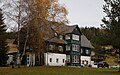
Schanzwirt - inn on the Schanz

Postbus bus stop
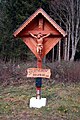
Pilgrimage cross of a sports club


literature
- Schanzwirt - The history of the Alpengasthof Schanz. June 22, 2009. Retrieved December 22, 2010 .
Web links
Individual evidence
- ↑ a b inscription on the peace cross
- ^ Fritz Posch: Flaming Frontier. Styria in the Kuruzzenstürme. 1st edition. Verlag Styria Graz 1968. P. 26, 81. 2nd edition as: Publications of the Steiermärkisches Landesarchives . Volume 5. Styria, Graz-Vienna-Cologne 1986. ISBN 3-222-11691-1 ZDB -ID 561078-3 .
- ^ State road directory L. In: Verkehrsserver Land Steiermark. 2010, accessed December 23, 2010 .
Ahorn • Alpl • Ammer • Annaberg • Arlberg • Ascher • Bieler • Birkfelder • Boding • Brenner • Buchauer • Buchener • Dientner • Dürrholzer • Eibegg • Erb • Eisental • Faschina • Feistritz • Fern • Filzen • Flattnitz • Flexen • Forsthof • Furka • Fuscher • Gaberl • Gaden wide • Gailberg • Gangleit • Geiseben • Gerichtsberg • Gerlos • Geschriebenstein • Goller • Grießen • Griffner • Large Kripp • Grubberg • Grünbacher • Gschuett • Hafner • Hahntenn • neck • Haselrast • Hebalm • stallion • Hengstl • Hiaslegg • Hirschegger • Hochegger • Hochrindl • Hochtannberg • Hochtor • Holzleiten • Iselsberg • Josefsberg • Kaiserauer • Cold Kuchl • Kartitscher • Katsch • Kernhofer • Kerschbaumer • Klachauer • Klamm • Klamml • Small Kripp • Klippitz • Klostertaler • Kraxen • Kreuth • Kreuzberg • Kühtai • Lahn • Lienbach • Loibl • Losen • Luft • Mendling • Michelbühel • Moarigraben • Nassfeld • Neumarkter • Niederalpl • Norberts • Nöring • Obdacher • Oberjoch • Och • Pack • Paulitsch • Perchauer • Pfaffen • Pfarralm • Pielachtaler • Piller • Plöcken • Pogusch • Pölshals • Pötschen • Präbichl • Prebersattel • Preiner • Pretal • Promau • Pyhrn • Radl • Radling • Radstädter • Radstatt • Rams • Raneck • Rechberg • Rieder • Rohrer • Sattler • Saurüssel • Schaida • Schanz • Scharflinger • Schiestel • Schober • Schönfeld • Schwarze Sau • Schwarzenbichl • Seeberg • Seefelder • Semmering • Kleiner Semmering • Sieggraben • Silzer • Soboth • Summer • Staller • Styrian Seeberg • Straßegg • Sölk • Thurn • Timmels • Triebener Tauern • Turracher • Origin • Wechsel • Weinebene • Weißenbacher • Wagrainer • Windische • Wurzen • Zellerrain