Mürz
| Mürz | ||
|
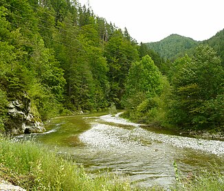
The Mürz between Mürzsteg and Neuberg |
||
| Data | ||
| location | Styria , Austria | |
| River system | Danube | |
| Drain over | Mur → Drava → Danube → Black Sea | |
| origin | The confluence of Stiller and Kalter Mürz near Kaltenbach (Gem. Neuberg an der Mürz ) 47 ° 45 ′ 11 ″ N , 15 ° 30 ′ 31 ″ E |
|
| muzzle | near Bruck in the Mur coordinates: 47 ° 24 ′ 35 ″ N , 15 ° 16 ′ 31 ″ E 47 ° 24 ′ 35 ″ N , 15 ° 16 ′ 31 ″ E
|
|
| length | 98 km | |
| Catchment area | 1,504.65 km² | |
| Discharge at the Kapfenberg-Diemlach A Eo gauge: 1,364.5 km² Location: 2.8 above the mouth |
NNQ (12/24/2001) MNQ 1971–2011 MQ 1971–2011 Mq 1971–2011 MHQ 1971–2011 HHQ (09/07/2007) |
1.78 m³ / s 8.378 m³ / s 22 m³ / s 16.1 l / (s km²) 133 m³ / s 244 m³ / s |
| Medium-sized cities | Kapfenberg | |
| Small towns | Mürzzuschlag , Kindberg , Bruck an der Mur , | |
| Communities | Neuberg , Langenwang , Krieglach , St. Barbara , Sankt Marein | |
The Mürz is a river in Austria . It is approx. 98 km long and has a mean flow rate (MQ) of 7 m³ / s in Neuberg and 22 m³ / s in Kapfenberg . The name comes from Muorica, the Slavic word for "little Mur".
course
The two source rivers of the Mürz arise north of the Schneealpe , the Stille Mürz in Lower Austria , the Cold Mürz in the Neuwald on the Styrian-Lower Austrian border. The upper course of the Mürz cuts through the Styrian-Lower Austrian Limestone Alps in an S-shape, forming the spectacular Dead Woman gorge with the waterfall of the same name after the village of Frein . Dobreinbach, Tirolbach and Raxenbach are the most important feeders to Mürzzuschlag . After the confluence of the Fröschnitz in the Mürz, the lower course extends in a south-westerly direction to the confluence with the Mur near Bruck. Significant feeders in this section are the Veitsch and, from the Hochschwab area, the Thörlbach and the Laming.
The route of the southern railway and the Semmering expressway (S6) run along the lower reaches of the Mürz.
Economical meaning
The occurrence of iron ore and the abundance of forests in the Mürz Valley gave rise to iron processing early on. The water of the Mürz was used to drive the hammer mills and to bring ( trift ) the wood from the forests of the upper Mürz Valley to the works. Several river power plants from Neuberg to Bruck an der Mur are used to generate electricity today. These are operated with Kaplan turbines , named after the inventor Viktor Kaplan, who was born in Mürzzuschlag . Here is a show power plant with one of the first turbines.
Tourism and fishing
The clear water and the wildness of the Mürz in its upper reaches made it a popular destination for fishermen and kayak enthusiasts. The natural landscape serves as the basis of the Mürzer Oberland Nature Park .
Web links
Individual evidence
- ↑ Federal Ministry of Agriculture, Forestry, Environment and Water Management (ed.) : List of areas of the Austrian river basins: Mur area. Contributions to Austria's Hydrography, Issue No. 60, Vienna 2011, p. 65 ( PDF ( Memento of the original from February 16, 2016 in the Internet Archive ) Info: The archive link has been inserted automatically and has not yet been checked. Please check the original and archive link accordingly Instructions and then remove this notice. )
- ↑ Federal Ministry for Agriculture, Forestry, Environment and Water Management (Ed.): Hydrographisches Jahrbuch von Österreich 2011. 119th Volume. Vienna 2013, p. OG 308, PDF (12.9 MB) on bmlrt.gv.at (yearbook 2011)
