Hochschwab group
| Hochschwab group | ||
|---|---|---|
| Highest peak | Hochschwab ( 2277 m above sea level ) | |
| location | Styria , Austria | |
| part of | Northern Limestone Alps | |
| Classification according to | AVE 18 | |
|
|
||
| Coordinates | 47 ° 37 ' N , 15 ° 9' E | |
The Hochschwab Group is a mountain group in the Northern Eastern Alps in Styria . The highest peak is at 2277 m above sea level. A. the eponymous Hochschwab .
location
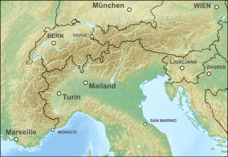
The mountain group is located in the eastern part of the Northern Alps in Styria .
The group is based on the Alpine Club division of the Eastern Alps (AVE):
- Großreifling - Salza - Gußwerk - Wegscheid - Seebergsattel - Seegraben - Stübmingbach - Thörlbach to confluence Mürz - Mürz to confluence Mur - Mur to Leoben - Vordernberger Bach - Präbichl - Erzbach - Hieflau - Enns to Großreifling
It includes:
- the Hochschwab massif ( Hochschwab group in the real sense):
- The extensive limestone plateau covers an area of approx. 400 km² and is bounded in the east by the Seebergsattel and in the west by the Präbichl . Only this massif belongs to the limestone high Alps of the Northern Limestone Alps .
- the Alfenzer Staritzen (can also be seen as the eastern branch of the Hochschwabstock)
- the Zeller Staritzen , in the far northeast
- Polster , Hochturm (Trenchtling) , Pribitz , Meßnerin - these are the southern fore floors of the Hochschwab east of the Präbichl
- the northern edge of the mountains Aflenzer Basin , for Hochschwabmassiv little separated the north and already mittelgebirgig with Ilgner Alpl , Aflenzer Bürgeralm , Oisching / Schießlingalm
- already part of the Grauwackenzone and the Central Alpine Crystalline :
- the mountains between Pichl-Großdorf and Etmißl
- the two groups around Kletschachkogel and Thalerkogel between Vordernbergertal and Lamingtal
- the Floning group from Lamingtal to the lower Thörlbach
As is customary in the country, only the limestone alpine part is referred to as the Hochschwab group, the southern parts systematically added by the alpine associations (along the significant orographic valley line), which are completely different in character, are included in the Mürz Valley Alps (Mürzberge) .
geology
The Hochschwab massif was the scene of huge landslides several times . Particularly noteworthy is that of Wildalpen , where about 4000 BC. A huge rock mass of the Ebenstein and Brandstein broke off and sagged to the north. As a result, the falling mass broke up and thundered as a torrent as far as today's Wildalpen into the Salzatal. There were two other landslides in prehistoric times in Tragöß (from the Messnerin with the damming of the Green Lake and by the Trenchtling with damming of the Pfarrerlacke).
The Hochschwab massif is also rich in caves, such as the extensive Frauenmauerhöhle .
From the Präbichl, Werfener layers (the clastic base of the Kalkalpendecken) and the Grauwackenzone (its slate basement with porphyroids and limestone, which also contains significant mineral resources) stretch north of the Aflenz basin, which gives this zone its low mountain range. A vein of Werfen strata runs northeast from the Präbichl (Griesboden, Jassinggraben, Ochsenboden, Ghf. Bodenbauer), which marks the significant southern flank of the Hochschwabstock in the headwaters of Laming and Ilgner Bach . The mountains Hochturm, Pribitz and Meßnerin to the south of it are pure limestone.
The southern part of the group is very different, it consists of central alpine crystalline ( Paragneiss , Kletschachkogel and Floning massifs).
Nature and sights

The intact fauna includes alpine marmots , chamois , alpine ibex , capercaillie , salamanders and adders . The largest chamois area in Europe is located on the Hochschwab. Accordingly, the gastronomy in the entire area is geared towards these game specialties. The flora is particularly diverse: among other things, auricles , lady's slipper , cabbage florets , edelweiss and various types of gentians can be found.
The Second Vienna High Spring Pipeline takes its water from the Kläffer spring in the northern Hochschwab area ( Wildalpen community ). When the snow melts, around 10,000 liters flow per second. Numerous buildings of the management are under monument protection.
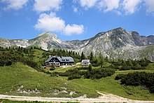
Noteworthy is the 2005 newly opened Schiestlhaus of ÖTK ( 2154 m ), which the world's highest passive house and replaced the 120 year-old predecessor. On the other hand, there are a number of small alpine huts where traditional alpine farming, gastronomy and simple overnight stays are combined (Pfaffingalm, Fölzalm, etc.).
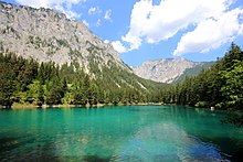
A few years ago, the Bodenbauer (Thörl) opened their own Hochschwab Museum. Some lakes in the Hochschwab area, e.g. For example, the Leopoldsteiner See near Eisenerz, the Brunnsee near Wildalpen or the Green Lake at Tragöß , offer drinking water quality. Other well-known standing waters are the Sackwiesensee near Tragöß and the Teufelssee between Eisenerz and Wildalpen.
Refuge huts in the Hochschwab group
- Voisthaler Hütte ( ÖAV , 1654 m ) - in a central location, at the foot of the Edelspitzen
- Sonnschienhütte (ÖAV, 1523 m ) - on the alp of the same name, in the west of the mountain group, at the foot of the Ebenstein
- Leobner Hütte (ÖAV, 1582 m ) - in the south-west of the mountain range, accessible from the Präbichl pass
- Schiestlhaus (ÖTK, 2154 m ) - northeast of the Hochschwab summit
- Butcher's bivouac (ÖAV, 2153 m, bivouac box) - on the western Swabian floor
- Fölzalm ( 1484 m ) - private, two alpine inns, surrounded by impressive rock and climbing peaks (e.g. Winkelkogel, Schartenspitze)
- Häuslalm ( 1526 m ) - private, on the plateau between Sonnschienalm in the west and Hochschwab summit in the east
- Gsollalm ( 1201 m ) - private, at the foot of the Frauenmauer, in the west of the mountain range
- Pfaffingalm ( 1550 m ) - private, on the alpine pasture of the same name in the west between Brandstein, Frauenmauer and Sonnschienalm
Distinctive elevations or peaks of the Hochschwab group

- Hochschwab ( 2277 m )
- Ringkamp ( 2153 m )
- Ebenstein ( 2123 m )
- Karlhochkogel ( 2096 m )
- Trenchtling (high tower) ( 2081 m )
- Großer Griesstein ( 2023 m )
- Beilstein ( 2012 m )
- Hoch Weichsel (Aflenzer Staritzen) ( 2006 m )
- Brandstein ( 2003 m )
- Riegerin ( 1939 m )
- Pfaffenstein ( 1871 m )
- Festlbeilstein ( 1847 m )
- Messnerin ( 1835 m )
- Hochblaser ( 1771 m )
- Thalerkogel ( 1655 m )
- Floning ( 1583 m )
- Pribitz ( 1579 m )
- Kampeck ( 1525 m )
- Kletschachkogel ( 1457 m )
List of peaks by Schartenhöhe
| No. | summit | Height (m) | Notch height (m) |
|---|---|---|---|
| 1. | Hochschwab | 2277 | 1051 |
| 2. | Messnerin | 1835 | 620 |
| 3. | Floning | 1583 | 576 |
| 4th | Prongs | 1619 | 525 |
| 5. | High tower | 2081 | 521 |
| 6th | Stangl | 1592 | 511 |
| 7th | Thalerkogel | 1655 | 501 |
| 8th. | Riegerin | 1939 | 494 |
| 9. | Brandstein | 2003 | 446 |
| 10. | Cold wall | 1929 | 409 |
| 11. | Oisching | 1699 | 408 |
| 12. | Ilgner Alpl | 1506 | 396 |
| 13. | Play walls | 1360 | 370 |
| 14th | Kampl | 1990 | 364 |
| 15th | Mieskogel | 1554 | 364 |
| 16. | Griesmauerkogel | 2034 | 357 |
| 17th | Ebenstein | 2123 | 348 |
Long-distance hiking trails
The Hochschwab group is crossed by the following long-distance hiking trails:
- North-south long-distance hiking trail 05
- North Alpine Trail 01
- European long-distance hiking trail E4 (alpine)
- European long-distance hiking trail E6
- Styrian regional hiking trail
- From the glacier to the wine
Important valley locations
Hochschwabmassiv i. e. S .:
Hochschwab group i. w. S .:
literature
- Günter and Luise Auferbauer: Hochschwab . Rother hiking guide ISBN 3-7633-4189-7
- Liselotte Buchenauer : Hochschwab , 1960 (2nd edition 1974), Leykam Verlag ISBN 3-7011-7044-4
- Rudolf Aegyd Lindner: Hochschwab . H. Weishaupt Verlag ISBN 3-900310-26-2
- Ewald Putz: Hochschwab. ISBN 3-85498-325-5
- Lukas Plan: Speleological-tectonic characterization of the karst water dynamics in the catchment area of the most important spring in the Eastern Alps (Kläffer spring, Hochschwab) - Diploma thesis at the Institute for Geology at the University of Vienna. (PDF; 3.2 MB) Verband Österreichischer Höhlenforscher, 2002, pp. 9–15 , accessed on December 8, 2009 .
Web links
- Huts of the Hochschwab group
- Hochschwab Museum Bodenbauer
- Wildalpen water pipe museum
- Rockslides in the Alps (Christof Kuhn)
- Entry on Hochschwabgruppe in the Austria Forum (in the AEIOU Austria Lexicon )
Individual evidence
- ↑ Alpine division , bergalbum.de (private website)
- ↑ a b c N.5, N.5a Hochschwabgruppe - Zeller Staritzen (Northern Alps) , Environmental Information Styria | Nature and landscape | Landscape structure
- ↑ Kellerer-Pirklbauer et al. (2009): The rockslide of Wildalpen (Hochschwab, Styria): New dendrochronological results of a tree fragment from the rockslide deposits. (PDF; 1.8 MB) accessed on October 29, 2010
- ↑ Abele, Gerhard (1974): Rockslides in the Alps. Their distribution, morphology and sequelae. Munich, German and Austrian Alpine Club


