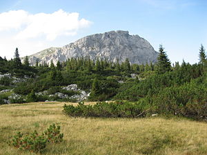
Brandstein (Hochschwab Group)
| Brandstein | ||
|---|---|---|
|
Brandstein from the south |
||
| height | 2003 m above sea level A. | |
| location | Styria , Austria | |
| Mountains | Hochschwab Group , Northern Limestone Alps | |
| Dominance | 2.86 km → Schaufelwand | |
| Notch height | 446 m ↓ sheep neck saddle | |
| Coordinates | 47 ° 36 '3 " N , 14 ° 58' 58" E | |
|
|
||
| rock | Dachstein Limestone | |
| Age of the rock | Triad | |
| particularities | southwest corner pillar of the rockslide of the Wildalpen | |
The Brandstein is a 2003 m above sea level. A. high mountain in the western Hochschwab group in the Austrian state of Styria .
Location and surroundings
The striking Brandstein stands as an isolated rock massif in the western part of the Hochschwab Group . It rises above the karst plateau, which is rich in dolines and covered by mountain pines , around four and a half kilometers northwest of the famous Sonnschienalm . To the west the massif is separated from the Kollmannstock ( 1768 m ) by the Höllsattel , in the east the ridge runs over the Schafhalssattel to Schaufelwand ( 2012 m ) and Ebenstein . South of the Brandstein are two alpine huts, the Pfaffingalm and the Androthalm, which are open in summer . In the north of the main summit is the Kleine Brandstein ( 1800 m ).
In addition, the district border between Liezen in the north and Bruck-Mürzzuschlag in the south runs over the summit .
Geology and geomorphology

The Brandstein massif is made up of Triassic Dachstein limestone and clearly stands out from its immediate surroundings. At the southern foot of the mountain, debris from the Wurm Age and a narrow west-east running band of Cretaceous conglomerates appear. The latter can be assigned to the calcareous Gosau. The plateau adjacent to the south is mainly composed of Wetterstein limestone.
The striking ridge between Brandstein and Ebenstein represents the trailing edge of a prehistoric landslide event . This impressive mass movement , known as the rockslide of the Wildalpen , takes up a volume of around 4 to 6 km³ and extends from the ridge down into the Salzatal . Today some clods of up to several 100,000 m³ offer an insight into the original rock formation. The shovel wall , at the foot of which the sliding surfaces of the landslide are exposed, is considered to be a relic of the latter.
Ascent
Most of the marked hiking trails on the Brandstein are easy, but long. Due to its remoteness, the summit is difficult to conquer on a day tour and is accordingly climbed less often than neighboring mountains. It has therefore already been dubbed “The great lonely mountain in the western part of the Hochschwab Group” . A particularly demanding variant is crossing east-west with difficulties of up to III + .
Starting points
- Sonnschienhütte , over the Androthalm : 3 hours
- Gsollkehre near Eisenerz ( 932 m ), over the Pfaffingalm : 4 hours
- Leopoldsteiner See , through the Fobistal : 5 hours
- Wildalpen , over the Schafhalssattel : 5½ hours
- Präbichl , via the Pfaffingalm : 5½ hours
-
Tragöß -Oberort
- via the Sonnschienhütte: 6 hours
- through the Jassinggraben : 6½ hours
Literature and maps
- Günter and Luise Auferbauer: Hochschwab. Bergverlag Rother , Munich 2001, ISBN 3-7633-4189-7 , pp. 31-32.
- Freytag & Berndt Vienna , hiking map 1: 50,000, WK 041, Hochschwab - Veitschalpe - Eisenerz - Bruck ad Mur , ISBN 978-3850847803 .
Web links
Individual evidence
- ↑ Digital Atlas of Styria: Geology & Geotechnics. (No longer available online.) State of Styria , archived from the original on June 15, 2012 ; accessed on October 8, 2015 . Info: The archive link was inserted automatically and has not yet been checked. Please check the original and archive link according to the instructions and then remove this notice.
- ↑ Dirk Van Husen & Alfred Fritsch: The Rockslide of Wildalpen (Styria) [1] (PDF; 6.39 MB), accessed on October 8, 2015
- ^ Andreas Kellerer-Pirklbauer, Kurt Nicolussi, Hermann Kain, Andreas Pilz & Andrea Thurner: The rockslide of the Wildalpen (Hochschwab, Styria). New dendrochronological results of a tree fragment from landslide deposits [2] (PDF; 1.8 MB), accessed on October 8, 2015
- ↑ Günter and Luise Auferbauer: Hochschwab (see literature)

