
Salza (Enns)
| Salza | ||
 Lower course near Palfau |
||
| Data | ||
| location | Austria | |
| River system | Danube | |
| Drain over | Enns → Danube → Black Sea | |
| source | at Ulreichsberg 47 ° 50 '14.7 " N , 15 ° 26' 49.4" E |
|
| muzzle | at Großreifling coordinates: 47 ° 40 ′ 14.23 ″ N , 14 ° 43 ′ 38.39 ″ E 47 ° 40 ′ 14.23 ″ N , 14 ° 43 ′ 38.39 ″ E |
|
| Mouth height |
449 m above sea level A.
|
|
| length | 88 km | |
| Catchment area | 868.3 km² | |
| Discharge at the Wildalpen A Eo gauge: 592.3 km² Location: 26.09 km above the mouth |
NNQ (January 24, 2006) MNQ 1951–2001 MQ 1951–2001 Mq 1951–2001 MHQ 1951–2001 HHQ (July 21, 1959) |
2.66 m³ / s 5.78 m³ / s 20.6 m³ / s 34.8 l / (s km²) 158 m³ / s 330 m³ / s |
| Communities | St. Aegyd am Neuwalde , Mariazell , Wildalpen , Landl | |
The Salza (also Mariazeller Salza ) is a mountain river in Austria and a right tributary of the Enns . It drains large parts of the Styrian-Lower Austrian Limestone Alps and, with its deep valley, separates the Göstling Alps from the Hochschwab massif .
Run
The Salza rises on the Ulreichsberg in Lower Austria and flows in a south-westerly direction and past Mariazell , where it makes a significant contribution to the Mariazell basin and also drains it. After 88 km it joins the Enns at Großreifling (449 m) . In a short section it forms the border between Lower Austria and Styria.
Nature and use
Today the Salza is one of the most natural wild rivers in the Eastern Alps. Downstream from Mariazell, it flows through the Wildalpener Salzatal nature reserve .
In the early modern times the Salza was an important river for the Trift von Holz, which was extracted here for the Erzberg , the small iron industry of the Ennstaler Eisenwurzen and for export. Below the town of Weichselboden is the Prescenyklause , which was built as a weir for the wood flood in 1848. Today the water from the reservoir is used to run a small power station.
Numerous sources of small tributaries of the Salza in the Hochschwab area are contained and feed their water into the second Viennese spring water pipeline . In recent years, a tunnel was cut that connects the Pfannbauern spring to the 1st line .
The Salza is considered by anglers to be one of the best rivers in the Alpine region for fly fishing . In addition, along with the Soča, it is one of the most beautiful kayaking and rafting rivers in the Eastern Alps, especially below the Presceny reservoir to the mouth.

Prescenyklause near Weichselboden
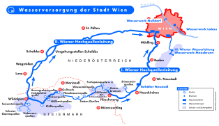
Site plan of the Vienna high spring pipelines

Salzatal, Anton Schiffer, lith. Around 1830


Web links
- Kayak tour through the Salzatal
- Evacuation plan of the Salza with entry and exit points as well as road kilometer information (PDF file; 273 kB)
- Entry on Salza (Enns) in the Austria Forum (in the Heimatlexikon)
Individual evidence
- ↑ Federal Ministry of Agriculture, Forestry, Environment and Water Management (ed.): List of areas of the Austrian river basins: Enns area. Contributions to Austria's Hydrography, Issue No. 61, Vienna 2011, p. 39 ( PDF; 3.9 MB ( Memento of the original from December 13, 2013 in the Internet Archive ) Info: The archive link has been inserted automatically and has not yet been checked. Please check Original and archive link according to instructions and then remove this note. )
- ↑ Federal Ministry for Agriculture, Forestry, Environment and Water Management (Ed.): Hydrographisches Jahrbuch von Österreich 2011. 119th Volume. Vienna 2013, p. OG 231, PDF (12.9 MB) on bmlrt.gv.at (yearbook 2011)