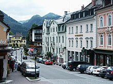
Mariazell
|
Borough Mariazell
|
||
|---|---|---|
| coat of arms | Austria map | |
|
|
||
| Basic data | ||
| Country: | Austria | |
| State : | Styria | |
| Political District : | Bruck-Mürzzuschlag | |
| License plate : | BM | |
| Surface: | 413.49 km² | |
| Coordinates : | 47 ° 46 ' N , 15 ° 19' E | |
| Height : | 868 m above sea level A. | |
| Residents : | 3,669 (January 1, 2020) | |
| Postcodes : | 3294, 8630, 8632, 8634, 8635 | |
| Area code : | 03882 | |
| Community code : | 6 21 42 | |
| NUTS region | AT223 | |
| UN / LOCODE | AT MZL | |
| Address of the municipal administration: |
Pater-Hermann-Geist-Platz 1 8630 Mariazell |
|
| Website: | ||
| politics | ||
| Mayor : | Walter Schweighofer ( ÖVP ) | |
|
Municipal Council : (2020) (21 members) |
||
| Location of Mariazell in the Bruck-Mürzzuschlag district | ||
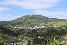
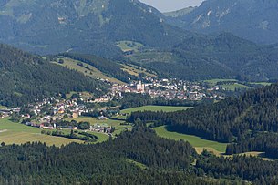 Mariazell from Gemeindealpe seen from |
||
| Source: Municipal data from Statistics Austria | ||
Mariazell is a municipality in northern Upper Styria near the Lower Austrian border with 3669 inhabitants (as of January 1, 2020). Mariazell is located in the judicial district of Bruck an der Mur , in the political district of Bruck-Mürzzuschlag and is the largest municipality in Styria and the third largest in Austria after Sölden in Tyrol and the federal capital Vienna .
Mariazell is by far the most important place of pilgrimage in Austria thanks to the statue of grace Magna Mater Austriae in the Basilica of the Birth of the Virgin and is also important for many Catholics in neighboring countries to the east. Winter sports are also practiced in Mariazell.
geography
Mariazell is the northernmost municipality in Styria and is located in the northern Limestone Alps . According to the Alpine Club division of the Eastern Alps , the municipality has shares in the Ybbstal Alps , the Türnitz Alps , the Mürzsteg Alps and the Hochschwab Group .
The Salza is the central water vein of the Mariazellerland. In addition, there are other noteworthy bodies of water in the municipality: the Erlaufsee and the Hubertussee, including the Walster . The village of Mariazell itself is located on a sloping plateau on the slope of the Bürgeralpe .
Community structure
Since 2015, Mariazell has been united with the previously independent municipalities of Gußwerk , Halltal and St. Sebastian as part of the municipal structural reform in Styria .
The municipality includes the following 16 localities (residents as of January 1, 2020):
- Aschbach (56)
- Open trench (0)
- Gollrad (91)
- Greith (46)
- Grunau (104)
- Cast iron (852)
- Hall Valley (197)
- Mariazell (1224)
- Moss hats (63)
- Rasing (65)
- Raking ditch (13)
- Saint Sebastian (849)
- Schöneben (0)
- Whale Star (17)
- Wegscheid (57)
- Weichselboden (35)
The five cadastral communities are (area 2016):
- Aschbach (17,127.79 ha)
- Halltal (7,455.28 ha)
- Mariazell (643.71 ha)
- St. Sebastian (4,742.16 ha)
- Weichselboden (11,440.56 ha)
Neighboring communities
Due to its large community area, Mariazell has nine neighboring communities, which are divided into two federal states and four districts. In clockwise order these are:
- Neuberg an der Mürz ( Bruck-Mürzzuschlag district , Styria )
- St. Barbara in the Mürz Valley (Bruck-Mürzzuschlag district, Styria)
- Turnau (Bruck-Mürzzuschlag district, Styria)
- Thörl (Bruck-Mürzzuschlag district, Styria)
- Wildalpen ( Liezen district , Styria)
- Gaming ( Scheibbs District , Lower Austria )
- Mitterbach am Erlaufsee ( Lilienfeld district , Lower Austria)
- Annaberg (Lilienfeld District, Lower Austria)
- St. Aegyd am Neuwalde (Lilienfeld district, Lower Austria)
climate
The Mariazellerland has a cold winter and only moderately warm to cool summer climate. It has a maritime character and, due to the location of Mariazell on the northern dam of the Alps, has a lot of rainfall. With 41.7% relative sunshine duration, “the Mariazeller area is one of the most disadvantaged areas in Austria. The forest and cultural boundaries are among the lowest in Austria. "
The winters are considered to be relatively snow reliable, with an average of 121 days a year of snow.
|
Average monthly temperatures and rainfall for Mariazell
Source: Central Institute for Meteorology and Geodynamics [3]
|
|||||||||||||||||||||||||||||||||||||||||||||||||||||||||||||||||||||||||||||||||||||||||||||||||||||||||||||||||||||||||||||||||||||||||||||||||||||||||||||||||||||||||||||||||||||||||||||||||||||||
history
Early days
In pre-Christian times and in the first century after Christ, no larger or closed settlements are detectable in the valley of today's Mariazellerland . However, mountain and river names of Celtic origin in the region indicate smaller settlements. Also likely to Celtic the salt springs in Halltal not have been unknown.
From around 200 BC The Mariazellerland belonged to the Kingdom of Noricum , to which several Celtic tribes had come together.
In the 1st century BC The Romans were already familiar with the salt path from Halltal to Traisental . Had signed a friendship treaty with the Kingdom of Noricum. 15 BC BC Emperor Augustus incorporated Noricum as an autonomous area into the Roman Empire. Emperor Claudius (41–54) took the remaining privileges and turned them into a Roman province. According to some reports, there was a Roman path coming from Neuhaus over the Zellerrain and the Brunnstein marble quarries into the Mariazeller area.
Under the onslaught of the Huns , Roman rule in the area largely collapsed at the beginning of the 5th century. Germanic tribes, which had already been settled from Rome within the imperial borders on what was to become Austrian soil, began to establish new settlements in addition to the Alpine Romans that still existed. In 476, rule south of the main Alpine ridge, in inland Noricum, passed to the Herulian army master Odoacer , north of it, in Ufernorikum, to the Germanic Rugians . In 489 rule in what is now Styria passed to Theodoric and the Ostrogoths , while in what is now Lower Austria it fell to the Germanic Lombards , who succeeded the Rugians. In the 6th century left Ostrom in the course of the fighting against the Ostrogoths the Lombards and the territory of the former Roman province Binnennorikum.
In 568, after the Longobards, together with the alleged Mongolian Avars , had destroyed the Gepid Empire to the east of the Vienna Woods , they withdrew to Italy, where they established the Longobard Empire . With the advancing Avars, who now took control of the area, Slavs came to the country as their vassals from around 590 and settled next to the still existing Alpine Roman and Germanic population. Here, too, the distribution can be proven on the basis of place and mountain names of Slavic origin (e.g. Ötscher - derived from the Slavic word “otec” for “father”).
In 743 the Mariazellerland came under Bavarian sovereignty together with the whole of Karantanien . At this point in time, the German history of the country began in the narrower sense and an increased German, mainly Bavarian settlement activity, which led to the formation of today's country.
The Bayern had freed their request the Alpine Slavs from the Avar rule. In 788, Charlemagne incorporated the Bavarian tribal duchy into the Franconian Empire . Towards the end of the Carolingian period , the German tribal duchies regained strength, including Bavaria, which was able to defend the Carantanian march as far as Mariazell against the Hungarians advancing in the 10th century . In 976, the Saxon Emperor Otto II separated the area south of the main Alpine ridge from the Duchy of Bavaria in order to weaken its influence within the German Empire. At the same time, a new Karantanische Mark was formed in the new Duchy of Carinthia , which became the cornerstone of the later Duchy of Styria.
middle Ages
In 1025, Emperor Conrad II gave his sister-in-law Beatrix - who was married to Adalbero von Eppenstein - parts of the county in the Mürz valley as a gift. The donation was 100 Huben (Low German "Hufe"), which also included the area of the later market in Mariazell. Long-standing disputes over this donation were fought before the Imperial Court and even before the Pope. In 1151, the Archbishop of Salzburg, Eberhard , decided in favor of the St. Lambrecht Monastery , which the last Eppensteiners (extinct in 1122) founded around 1100. Shortly afterwards, the parish of Mariazell and the rule of Aflenz were divided . From a document from Pope Hadrian IV we take the date December 21, 1157 - this day is still traditionally celebrated as the founding day of Mariazell, even if it cannot be historically proven.
In 1157 the monk Magnus came to the Zellertal with his statue of the Virgin Mary carved from linden wood and built the first chapel around the statue standing on a tree trunk, around which the later town grew. According to legend, this had previously divided a rock that blocked the way. The name Mariazell arose from 'Maria in the cell'.
In 1344 the place was raised to the market . 1340–1380 the church was rebuilt in the Gothic style .
The Turks came to Mariazell for the first time in 1420, when the village and the church burned. In 1474 another fire devastated the place. In 1532 the Turks came to Mariazell again and set several houses on fire. The church was spared this time.
Modern times
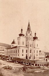
In 1644 Abbot Benedikt Pierin initiated the Baroque transformation of the church and commissioned the builder Sciassia with the work . After his death, the construction work was continued by various builders and completed in 1780.
In 1679, Emperor Leopold I visited the Mariazell Mother of Grace and brought the plague to Mariazell in his entourage through an infected valet . 156 people fell victim to the disease.
In 1683, fearing renewed Turkish invasions, the statue of grace and the treasury picture were brought to St. Lambrecht, from where they came back in the same year.
In 1742 the Empress Maria Theresia granted the abbot Eugen Inzaghi the privileges to mine ore in Gollrad and Aschbach, as well as to build and operate a Mariazell iron casting plant . In 1786, Emperor Joseph II also abolished the St. Lambrecht Abbey as part of his abolition of the monastery, which also affected Mariazell. The pilgrimages were made more difficult and later prohibited entirely.
In 1798 another major fire devastated the site, primarily on Wiener Strasse. In 1805 there was fighting with the French troops under Napoleon in the battle of Mariazell . In 1809 the church treasure was brought to Temesvár in Hungary from the French troops . A few weeks later, the French entered Mariazell. Combat, requisition and crop failures led to the bleeding of the population in these years.
1816 turned into a real famine year . Archduke Johann had the potato imported and poor fields set up in the area to combat hunger. Archduke Johann bought the Brandhof in 1818 .
In 1827 the biggest fire broke out on All Souls' Day, which cremated almost the entire place and in which the church suffered severe fire damage. 1828-1832 the place could be rebuilt with great effort and sacrifice.
In 1892 an electricity works was built in the iron mill's disused boring mill and in the following years Mariazell was supplied with electricity for the first time. In 1896 the first general aqueduct was built. In 1898 the Mariazell iron foundry was shut down.
In 1907 the Mariazellerbahn, which was completed the year before, was opened to public transport. In 1911 the Mariazellerbahn was electrified.
In 1924 the first festival opened in the newly built festival hall. The festival reached its peak in 1925. In the following years, however, there was financial decline and the end of the games.
In 1928, a gondola lift up to the Bürgeralpe was built as one of the first cable cars in Austria . In the same year, the general water line was expanded to include the “student source”.
Second republic
In 1945 the Red Army of the Soviet Union moved into Mariazell and took up quarters with 5,000 men, but as part of Styria the place came under the British occupation zone later that year.
In 1948 Mariazell was promoted to town . A general church renovation took place 1955–1957. During these years the bypass and a new post office were built.
In 1966, the Fathers of Kremsmünster Monastery replaced the Fathers of Schottenstift , who had been Mariazell’s church leader since 1949. In the following years, extensive renovation work was carried out on the church and the rectory as well as the surrounding chapels and the new Rosary Path was built.
In 1976 Mariazell received an indoor swimming pool and a few years later an extension of the secondary school .
In 1983 Pope John Paul II visited Mariazell. The papal altar was set up on the main square. In the course of this major event, extensive facade renovations were carried out throughout the city, the main square was redesigned and parking spaces were created.
In 1990 a thanksgiving and freedom pilgrimage of the former Eastern Bloc countries took place with 25,000 participants.
In 1992 the Benedictines from Kremsmünster handed over the pilgrimage pastoral care to the care of the founding monastery and mother monastery of St. Lambrecht .
In 1988 the Mariazellerbahn between Mariazell and Gußwerk was discontinued and in 2003 the Mariazellerbahn between Mariazell and Gußwerk was dismantled.
2004: Central European Catholic Day - pilgrimage of the peoples to Mariazell with over 100,000 visitors.
2007: Bartholomäus I , 270th successor of the Apostle Andrew and Ecumenical Patriarch of Constantinople , head of the approximately 300 million Orthodox Christians, visits Mariazell. From August 12th to 15th, 2007, the Austrian bishops invited to a youth pilgrimage to Mariazell. Around 3000 young people from Bosnia-Herzegovina, Croatia, Poland, Slovakia, Slovenia, the Czech Republic, Hungary and Austria took part.
On September 8, 2007 Pope Benedict XVI visited Mariazell to celebrate a divine service (Vespers) on the occasion of the 850th anniversary of the basilica . After the Christmas market on the main square opened for the first time on Saturday, November 19, 2016, the decorated Christmas tree fell over the following night in strong gusts of wind. There was no consequential damage, the luminous jewelry remained in function.
Population development

politic and economy
Community representation
The municipal council consists of 21 members and will be composed as follows after the 2020 municipal council elections :
City government
- Mayor has been Walter Schweighofer (ÖVP) since 2020
- 1st Vice Mayor Helmut Schweiger (ÖVP)
- 2nd Vice Mayor Johann Kleinhofer (SPÖ)
- Finance Officer Jürgen Ebner (ÖVP)
- City Councilor Fabian Fluch (SPÖ)
- mayor
- 1858–1863 Franz Geraus
- 1863–1869 Johann Götz
- 1869–1873 Josef Lang
- 1873–1896 Johann Laufenstein
- 1896–1903 Franz Ritter
- 1903–1910 Gottfried Buschnigg
- 1910–1911 Johann Rögl
- 1911–1924 Karl Laufenstein
- 1924–1932 Roman Feichtegger
- 1932–1938 Alexander Globotschnigg
- 1938–1938 Alois Knaus
- 1939–1945 Josef Scheucher
- 1946–1955 Hans Laufenstein
- 1955–1979 Alfred Schöggl
- 1979–1990 Karl Pingl (ÖVP)
- 1990-2010 Helmut Pertl (ÖVP)
- 2010–2014 Josef Kuss (ÖVP)
- 2015–2019 Manfred Seebacher (SPÖ)
- 2019–2019 Michael Wallmann (SPÖ)
- 2019-2020 Johann Kleinhofer (SPÖ)
- since 2020 Walter Schweighofer (ÖVP)
badges and flags
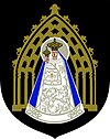
Due to the amalgamation of the municipalities, the coat of arms lost its official validity on January 1st, 2015. The re-award took place with effect from November 1, 2015.
The blazon (description of the coat of arms) reads:
- “In a black shield the stylized representation of the Gothic arch of the basilica of Mariazell in gold; in front of it, also in gold, the crowned Mariazell Madonna with the likewise crowned baby Jesus on her right arm. The Madonna is dressed in a blue cloak and a white, silver-embroidered robe that also envelops the Infant Jesus; the robe is adorned with a white cross on the chest of the two figures . "
The city flag (since 1958) has three stripes in blue-white-yellow with the coat of arms.
Regional policy
The municipality is part of the Leader region Mariazellerland – Mürz Valley and a member of the Agenda 21 and tourism region Mariazeller Land , whose Styrian municipalities also form the Regionext small region of the name.
Town twinning
In the collaboration Shrines of Europe , Mariazell has been connected to five other Marian shrines since 1996 ; In 2017 Einsiedeln became the seventh member. The partner locations are:
-
 Altötting , Germany , Bavaria Place of pilgrimage and district town
 -
 Einsiedeln , Switzerland
-
 Fátima , Portugal
-
 Loreto , Italy
-
 Lourdes , France
-
 Czestochowa , Poland
Economy and Infrastructure
Pilgrimage tourism is the most important industry in the region. Cast steel and wood harvesting used to be the main sources of income for the region.
traffic
Street
Mariazell is a traffic junction. There are four state roads running through the municipality:
- Mariazeller Straße B 20, leads from Kapfenberg over the Seeberg and Annaberg through the Traisental to Sankt Pölten
- Gutensteiner Straße B 21, leads from Mariazell via Sankt Aegyd / Neuwald and Gutenstein to Wiener Neustadt
- Hochschwab Straße B 24, leads from Mariazell through the Salzatal to Landl
- Zellerrain Straße, leads over the Zellerain into the Ybbstal to Lunz am See
train
Mariazell is also the southern end point of the Mariazellerbahn , a narrow-gauge and historically electrified railway line from the St. Pölten Alpine Station through the Pielach Valley to Mariazell; However, the train station is one kilometer (15 minutes' walk) from the center ( Sankt Sebastian district ). The railway line led to Gußwerk, but operations there ceased in 1987. A museum tram also runs from Mariazell station to the nearby Erlaufsee . An extension of this museum line from the train station to the outskirts of Mariazell has been under construction since 2007.
Bike path
Along with Traismauer, Mariazell is one of the endpoints of the Traisental cycle path
Culture and sights
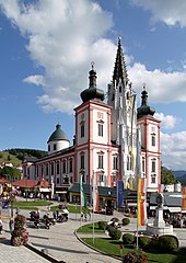
Mariazell Basilica
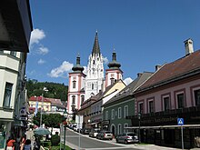
A gothic basilica from the 14th century. The splendid Baroque interior and the three towers on the western front are striking. The church houses the Magna Mater Austriae in the so-called Gnadenkapelle . This miraculous image is a small wooden statue of the Virgin Mary from the 13th century, which is dressed in a magnificent robe and plays an important role in the popular piety of many Catholics from all over Central Europe.
Pilgrimage routes
Numerous national and international pilgrimage routes lead to Mariazell. Some of these are:
- Via Sacra from Vienna ( Mödling )
- The seven branches of the Austrian long-distance hiking trail 06 ( Mariazeller Ways ):
- Carinthian Mariazellerweg from Klagenfurt
- Styrian Mariazellerweg from Eibiswald via Graz
- Burgenland Mariazellerweg from Eisenstadt
- Viennese Mariazellerweg (also Viennese pilgrimage route ) from Vienna-Rodaun or Perchtoldsdorf
- Lower Austrian Mariazellerweg from Nebelstein
- Upper Austrian Mariazellerweg from Pöstlingberg near Linz
- Salzburg Mariazellerweg from Salzburg
- Mariazeller founding way from St. Lambrecht
- International Marienpilgerweg I23 from Czestochowa
- Mária Út from Transylvania
The north-south long-distance hiking trail (Austrian long -distance hiking trail 05) and the European long-distance hiking trail E6 also run through Mariazell.
Personalities
Honorary citizen
- Alexander Setznagel (1801–1887), Dept.
- 1888: Othmar Murnik (1835–1901), Dept.
- 1928: Anton Rintelen (1876–1946), Governor of Styria 1919–1926, 1928–1933
- 1961: Gabriel Beda-Döbrentei (* 1912), Benedictine
- 1972: Franz Wegart (1918–2009), Deputy Governor
- 1978: Maximilian Aichern (* 1932), bishop
- 1983: Josef Krainer (1930–2016), Governor of Styria 1980–1996
- 1990: Karl Pingl († 2019), Mayor of Mariazell 1979–1990
- 1994: Richard Feischl, Honorary Section Fire Inspector
- 2005: Christoph Schönborn (* 1945), cardinal
- 2005: Egon Kapellari (* 1936), bishop
- 2005: Waltraud Klasnic (* 1945), Governor of Styria 1996–2005
- 2007: Christian Konrad (* 1943), bank manager
- 2008: Benedict XVI. (* 1927), Pope
- 2009: Karl Schauer, Benedictine
- 2012: Matthias Pirker (1939–2018), entrepreneur
- 2014: Helmut Pertl, Mayor of Mariazell 1990–2010
sons and daughters of the town
- Sebastian Ertel (around 1550 / 1560–1618), composer
- Hans Gumplmayer (1884–1969), SPÖ politician
- Fritz Pingl (1931–2015), track and field athlete
- Otto Leodolter (* 1936), ski jumper
- Kurt Spurey (* 1941), ceramist
- Grete Digruber (1945–2010), ski racer
- Marie Luise Kaltenegger (* 1945), journalist and publicist
- Peter Loidolt (* 1945), festival director
- Hanne Egghardt (* 1948), author, translator and journalist
Personalities associated with the city
- Robert Kramreiter (1905–1965), architect
- Maria Henriette of Austria-Teschen (1883–1956), noblewoman
- Viktorin Weyer (1866–1939), Dept.
literature
- Liselotte Blumauer Montenave: Bibliography of the pilgrimage site Mariazell . Vienna Catholic Academy, Vienna 1973
- Helmut Eberhart, Heidelinde Fell (ed.): Mariazell - treasure and fate . Catalog of the Styrian State Exhibition, Graz 1996, ISBN 3-901704-01-9 .
- Erika Käfer, Fritz Käfer: Pilgrim routes to Mariazell , volume Ost + Nord, 2009
- Maximilian Liebmann : Mariazell in the mirror of ecclesiastical, religious and political life in Central Europe (PDF file; 129 kB). Contribution to the symposium The Last of History - Mariazell and Marialogie from the Reformation to the 20th Century . 2007
- Ingrid Schubert: Mariazell. In: Oesterreichisches Musiklexikon . Online edition, Vienna 2002 ff., ISBN 3-7001-3077-5 ; Print edition: Volume 3, Verlag der Österreichischen Akademie der Wissenschaften, Vienna 2004, ISBN 3-7001-3045-7 .
Web links
- 62142 - Mariazell. Community data, Statistics Austria .
- www.stadt-mariazell.at , website of the municipality
- www.mariazell.at , Mariazell Online Tourism Portal
Entry on Mariazell in the Austria Forum (in the AEIOU Austria Lexicon )
- Chamois tannery in Mariazell / Rasing (1985). in the online archive of the Austrian Media Library (ÖWF film; 42 min.)
Individual evidence
- ↑ Announcement of the Styrian state government of October 10, 2013 on the unification of the municipality of Mariazell and the municipalities of Gußwerk, Halltal and Sankt Sebastian, all political districts of Bruck-Mürzzuschlag. Styrian Provincial Law Gazette of November 15, 2013. No. 121, 32nd issue. ZDB ID 705127-x . P. 631.
- ↑ Statistics Austria: Population on January 1st, 2020 by locality (area status on January 1st, 2020) , ( CSV )
- ↑ Federal Office for Metrology and Surveying, Regional Information, reference date December 31, 2016, accessed February 19, 2017
- ↑ [1]
- ↑ [2]
- ↑ Sturm felled Mariazeller Christmas tree orf.at, November 20, 2016, accessed November 23, 2016.
- ↑ a b Change of mayor in Mariazell. In: mariazell.at. August 5, 2020, accessed August 5, 2020 .
- ^ Mariazell: Former mayors . Retrieved June 2, 2019.
- ^ Castling in Mariazell: Local chief says goodbye in Mariazell . Article dated April 14, 2019, accessed April 14, 2019.
- ↑ "Kleini" is the new mayor of Mariazell . Meinviertel.at of December 17, 2019. Retrieved December 18, 2019.
- ↑ 83. Announcement of the Styrian state government of October 1, 2015 on the granting of the right to use a municipal coat of arms to the municipality of Mariazell (political district Bruck-Mürzzuschlag) , accessed on October 12, 2015
- ↑ Entry on Mariazell on the website kommunalflaggen.eu
- ↑ International pilgrimage route Via Slavorum (PDF; 2.4 MB) in the Pertoldsdorfer Rundschau 10/2009
- ↑ Pilgerwege Mariazell, accessed online on January 8, 2013
- ↑ Grazer Tagblatt, evening edition (December 15, 1928), p. 2.
- ↑ Südost-Tagespost (March 21, 1961), p. 1.
- ↑ Südost-Tagespost (September 19, 1972), p. 8.
- ↑ a b c d e f g h i j k l URL: https://www.mariazell.gv.at/ehrenbuerger (accessed on November 4, 2018)
