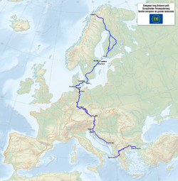
European long-distance hiking trail E6
| European long-distance hiking trail 6 | |
|---|---|

|
|
| Data | |
| Markers |

|
| Starting point |
Kilpisjärvi 69 ° 2 ′ 57 ″ N , 20 ° 47 ′ 40 ″ E |
| Target point |
Dardanelles / 40 ° 13 ′ 6 ″ N , 26 ° 27 ′ 29 ″ E |
| Type | Long-distance hiking trail |
The European long-distance hiking trail 6 is part of the European hiking trail network and leads from Kilpisjärvi in northwest Finland to the Dardanelles in Turkey .
Route
It leads from north to south through the following countries, regions and cities:
- Finland
-
Sweden
- Malmo
- Oresund Bridge - by train or car
-
Denmark
- Kastrup
- Korsør
- Storebelt Bridge - by train or car
- Nyborg
- Svendborg
- Ferry to Ærø, then ferry to Als
- Kruså (coincidence with the European long-distance path E1 )
-
Germany
-
Schleswig-Holstein
- Border crossing
- Flensburg
- Schleswig
- Eckernförde
- Kiel
- Plön
- Eutin
- Neustadt in Holstein (meeting the European long-distance hiking trail E9 )
- Lübeck
- Ratzeburg see also Alte Salzstrasse
- Mölln
- Güster (junction of the European long-distance hiking trail E1 )
- Books
- Lauenburg
-
Lower Saxony
- Bleckede
- Schnega
- Bad Bodenteich
- Gifhorn - Mill Museum
- Braunschweig
- Wolfenbüttel
- resin
- Göttingen (from Göttingen to Hann. Münden on the student path )
- Hann. Münden
-
Hesse
- Witzenhausen
- Eschwege
- Rhön (coincidence with the European long-distance hiking trail E3 )
- Bavaria
-
Schleswig-Holstein
- Austria (to Nebelstein the E6 runs on the Nordwaldkammweg , from there to Eibiswald on the north-south long-distance hiking trail 05 )
- Slovenia
From here or from Rijeka in Croatia by boat to:
literature
- Eduard Brauns (ed.): European long-distance hiking trail. 6 . tape 6 : Baltic Sea, Wachau, Adriatic Sea. . German hiking publisher Mair u. Schnabel, Rum / Innsbruck 1978, ISBN 3-8134-0049-2 ( Roskilde, Flensburg, Eschwege, Waldmünchen, Dreisessel, Eibiswald, Kastav, Rijeka ).
- Hans-Jürgen Zebisch (Ed.): European long-distance hiking trail. 6 . 1st edition. tape 6 : Baltic Sea - Wachau - Adriatic Sea . Fink-Kümmerly and Frey, Stuttgart 1979, ISBN 3-7718-0307-1 ( Nebelstein - Rijeka ).
- Erika Käfer, Fritz Käfer: Austrian long-distance hiking trail 05. From the Waldviertel highlands to the Windischen Büheln . Ed .: Austrian Alpine Association, Section Long-Distance Hikers. June 2020.
- Erika Käfer, Fritz Käfer: European long-distance hiking trail E6 SLO (Ciglar Weg). In 15 stages from the Drava to the Adriatic . Ed .: Austrian Alpine Association, Section Long-Distance Hikers. April 2019.
- Od Drave do Jadrana = From the Drava to the Adriatic Sea: European long-distance hiking trail E-6 YU. Hiking booklet . [sn], Ljubljana 1983, OCLC 444052003 .
Web links
Commons : European long distance path E6 - collection of pictures, videos and audio files
Wikivoyage: E6 European long distance path - travel guide

