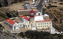
Cabo de Sao Vicente
The Cabo de São Vicente [ ˈkabu dɯ sɐ̃u viˈsẽtɯ ] ( Cape Saint Vincent ) near Sagres in Portugal, together with the neighboring Ponta de Sagres, forms the south-western tip of mainland Europe. The Algarve ends there in a rocky, up to 70 meter high cliff with barren, treeless vegetation.
myth
The cape has been a sacred place since the Neolithic , as menhirs (stone setting) in the area show. In the times of the Phoenicians it is said to have been dedicated to the deity Melkart . The Greeks called the place Ophiussa (land of snakes) and its inhabitants Oestrimni (inhabitants of the extreme west), by the Romans it was called Promontorium sacrum (sacred promontory), as a magical place at the end of the world where the gods live and the The sun is sinking into the sea.
The Christians named the tip of the coast after Saint Vincent of Saragossa , a patron saint of seafarers . According to legend, the martyr's body was driven there in a boat and recovered in 304 .
shipping
On the Cabo de São Vicente there is a lighthouse whose light cone extends 32 nautical miles (almost 60 kilometers) across the Atlantic and which is considered to be the brightest lighthouse in Europe.
On one of the world's busiest sea routes , ships keep a large safe distance from the Cape.
At Cabo de São Vicente at least four major naval battles and battles took place over the centuries :
- the naval battle at Cape St. Vincent (1681) on September 30, 1681 between Spanish and Brandenburg squadrons,
- the sea battle at Cape St. Vincent (1780) on January 16, 1780 between the British and Spanish fleets in the North American War of Independence,
- the naval battle at Cape St. Vincent (1797) on February 14, 1797 between the British and Spanish fleets in the First Coalition War,
- the naval battle at Cape St. Vincent (1833) on July 5, 1833 between the British and Portuguese fleets in the Miguelistenkrieg.
tourism
The place is frequented by bus from large numbers of international tourists from the surrounding Algarve who approach the Cape via Sagres. The route of the largest bus company EVA runs from Portimão via Lagos there.
See also
Cabo da Roca - the westernmost point of continental Europe
Web links
Individual evidence
- ↑ portugalvirtual.pt , accessed on October 4, 2007
- ↑ Missler: Algarve , p. 134
- ↑ Scope according to Leuchtturm-web.de , accessed on October 4, 2007 and http://www.marinha.pt/extra/revista/ra_abr2004/pag_35.html ( Memento from April 10, 2009 in the Internet Archive )
literature
- Missler, Eva: Algarve . Ostfildern: Baedeker 2002, ISBN 3-89525-120-8 .
Coordinates: 37 ° 1 ′ 21.4 " N , 8 ° 59 ′ 48.2" W.


