European long-distance hiking trail E9
| European long-distance hiking trail E9 | |
|---|---|
 Cabo de São Vicente at the southwest end of the trail |
|
| map | |

|
|
| Data | |
| Markers |

|
| Starting point |
Cape St. Vincent 37 ° 1 ′ 22.5 ″ N , 8 ° 59 ′ 47 ″ W. |
| Target point |
Narva-Jõesuu 59 ° 28 ′ 5.1 ″ N , 28 ° 2 ′ 25.1 ″ E |
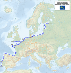
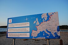
The European long-distance hiking trail E9 or International Coastal Trail Atlantic – Baltic Sea is one of the eleven long-distance hiking trails that are managed by the European Hiking Association (ERA) . The route has a length of around 5,000 km so far and leads from Portugal along the coasts of the Atlantic , the North Sea and the Baltic Sea to Estonia . An alternative route is available when crossing the English Channel on the south coast of England . The long-distance hiking trail is not yet developed and marked in all countries. While the Central European route between Brittany and the Vistula is complete, essential sections of the route are still missing on the Iberian Peninsula , on the Atlantic coast of southern France and in the Baltic States .
Course and expansion
The E9 begins at the southwestern point of mainland Europe at Cabo de São Vicente , crosses the Parque Natural do Sudoeste Alentejano e Costa Vicentina in its entire length, grazes Lisbon and Porto , follows the Caminho Português and crosses the Spanish border at Valença . In Portugal, however , the expansion of the hiking trail is not complete and the labeling is also incomplete.
The E9 is also developed very differently in Spain and is only continuously marked on the route between Irun and Ribadeo in the Basque Country .
In the south of France , the exact course of the trail along the coast of the Biscay has not yet been determined. The long-distance hiking trail is only set up from Vannes and the route follows the French long-distance hiking trails and customs officers' paths along the Breton coast to Mont-Saint-Michel .
From Roscoff the E9 splits and after crossing the English Channel there is an alternative route between Plymouth and Dover along the English south coast. The route follows the South West Coast Path and the South Downs Way, among others .
The route on mainland Europe leads through Normandy to Calais , where the two routes meet again. After the Belgian border, the long-distance hiking trail runs from the seaside resort De Panne along the 70 km long Belgian North Sea coast to De Haan and then through Flanders to the Dutch border.
In the Netherlands , the long-distance hiking trail is on the 725 km long North Sea Coast Path (Nordzee Kustpad - LAW 5). From Sluis it crosses all the Dutch coastal provinces ( Zeeland , Zuid- and Noord-Holland , Friesland and Groningen , before reaching the German border at Reiderland .
The German part of the E9 is maintained by three different hiking associations. For the routing along the East Frisian coast between Dollard and Weser is Wiehe mountain Weser-Ems responsible. The long-distance hiking trail is here via the main hiking trails Ems-Dollart-Pad (to Weener ), Emsweg (to Leer ), Ostfrieslandweg (to Aurich ), Ems-Jade-Weg (to Wilhelmshaven ), Jadeweg to Petershörn , Butjadinger Weg (to Nordenham ).
From the east bank of the Weser, the path leads through the area of the Northern Germany Hiking Association. It goes via Bremerhaven , Bad Bederkesa , Wingst first to Wischhafen and then on the eastern bank of the Elbe via Glückstadt and Elmshorn to Hamburg . The long-distance routes E1 and E6 are crossed at Güster . After Mölln and Ratzeburg , the E9 reaches the Baltic Sea at Lübeck-Travemünde .
The further course through Mecklenburg-Western Pomerania is supervised by the German Hiking Association (LV MVP). The route between Travemünde and Ahlbeck is also largely in the immediate vicinity of the coast. The Vorpommersche Boddenlandschaft National Park , the Fischland-Darß-Zingst and Wolgast peninsula are crossed before the Polish border is reached on the island of Usedom .
- Poland: Swinoujscie, Gdansk, Vistula region, Braniewo
- Estonia: Narva-Jõesuu

literature
- Johanna Jawinsky: Ostseeküstenwanderweg E9: On the European long-distance hiking trail E9 from Travemünde to Ahlbeck . With map part. 2004. ISBN 3935621949
Web links
- Openstreetmap map
- The European long-distance hiking trail E9
- Description of the E9 on outdoorseiten.net
- On the coasts from Portugal to Estonia: The Europe long-distance hiking trail E9
- Route in Germany Detailed descriptions of the stages from the Dutch border to the Polish border, route sketches, elevation profiles and photos
Individual evidence
- ↑ Route of the E9 on era-ewv-ferp.com
- ^ Northseatrail. Archived from the original on October 5, 2013 ; accessed on February 18, 2018 .
- ^ Wiehengebirgsverband Weser-Ems: E9 , accessed on February 18, 2018
- ↑ E9 to Wanderverband-Norddeutschland
- ^ Wanderable Germany: E9