
Dollard

The Dollard ( Dutch Dollard ) is an approximately 90 square kilometers large bay in Mündungsästuar the Ems south of the seaport city of Emden . The Dollart is fed from the south with fresh water from the Westerwolder Aa (Dutch: Westerwoldse Aa). In the north-west, the Dollartmund , which is just under two kilometers wide between the Punt van Reide headland on the Dutch bank and the Geiserücken, provides the connection to the Outer Ems and thus to the North Sea .
history

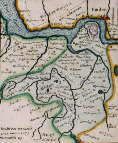
The bay is similar to the Jade Bay , the result of marine burglaries in the late Middle Ages , the original moorland have largely been dispelled. The older view presented by Ubbo Emmius says that the Dollart was created as early as 1277. This tradition finds its expression in mythical form in Jarfke van der Muydens Prophecye , but is not confirmed by contemporary sources. The alleged year of origin 1362 ( Second Marcellus Flood ) is by no means certain. According to a tradition reported by the East Frisian chronicler Eggerik Beninga , the most important sluices were only destroyed during a feud in 1413 . Five years later, the water is said to have reached the later village of Blijham for the first time. Nevertheless, archaeological finds near Bad Nieuweschans (Bad Neuschanz), Vriescheloo and Scheemda show that fresh water conditions still prevailed here in the 15th century. In contrast, halophilic vegetation existed at Pogum two centuries earlier .
The eastern dollar bosom formed in the first half of the 15th century. As early as 1454 an emergency dike was built from the solid bank of the Ems across the moor to the high Geest near Finsterwolde, which was supposed to protect the Oldambt . The western bosom probably didn't appear until the 1460s. Large parts of this area were still largely untouched by the sea when the Second Cosmas and Damian Floods in 1509 and then the Antoni Flood in 1511 penetrated far into the interior.


With the creation of the Dollard and the collapse of the Emsbank, at least 20 parishes and 10 to 15 other villages and three monasteries perished. A dozen village churches have been relocated once or even twice. However, the names of these villages are often garbled.
The parishes of Kalentwalt (Coldeborgerfehn?), Haxenerwalt (Hatzumerfehn?), Ditzumerwold, Uterpogum, Utbeerte, the market towns of Torum , Wilgum, Fletum, Berum, Oosterreide, Westerreide, Up-Reiderwolde and Ut-Reiderwolde (with a Kollegiatstift) went under (t) dorp, Stockdorp , Tijsweer, Zwaag, Ooster-Finsterwolde, Ulsda, Megenham, Wynedaham, Houwingagast (Houwingahof), Houwingaham and perhaps the hard-to-identify parishes of Haxne, Siweteswere, Poel, Rodendebord and Katelmesinke.
In addition the villages Peterswere (Peterswolde), Dune Lee (Duinkerken near Marienchor?), Garmede, Wynham, Jarde (Bundergaarde), Bonewerda ( Boen ?), Ockeweer, Astock , Torpsen, De Lidden, Gaddingehorn, Fiemel and maybe Ayckaweren, Stoksterhorn, Exterhuis, Jansum and Homborg. And finally, the Palmar (Porta sancta Mariae) , Oosterreide and Menterwolde (Sylvae campus) monasteries with the De Olde Stoeve monastery. The existence of the villages Beda, Ludgerskerke, Osterbeerde, Maarhuisen and Markhuisen can be questioned, as these are not proven by contemporary sources.
Nesse, Kirchborgum (Huweghenborch), Bingum (Oengum) and the Goldhoorn monastery suburb (near Finsterwolde) are probably wrongly counted among the submerged settlements. Other former bog settlements may already have fallen into desolation before the dollar slump because of their low location and were only subsequently included in the lists of submerged villages.
At least 17 settlements were relocated to a higher location because of the flooding: Marienchor (Critzumerwolde), Böhmerwold (probably * Bentumerwolde), St. Georgiwold (Upwolde), Weenermoor , Boen (Bonewerda), Wymeer , Hamdijk (Houwingaham or Utham), Den Ham (Upham or Nijeham), Bellingwolde , Vriescheloo, Winschoten -Sint-Vitusholt, Beerta, Oostwold, Midwolda, Scheemda, Meeden, Muntendam and perhaps the predecessor settlements of Bunderhee and Blijham. The church villages Noordbroek and Zuidbroek and possibly also the Kommende Dünebroek were relocated earlier.
As a result of the dollar slump, the Ems loop in front of Emden was cut off in 1509. While the Ems previously flowed directly under the ramparts of the city of Emden, after the storm surge the river bed shifted into the newly created tendon of this arch. As a result , the Nesserland peninsula opposite Emden became an island , and the arc, now abandoned by the main current, silted up more and more, making access to Emden harbor increasingly difficult. The city of Emden tried to seal off the newly created Emsbett through an approximately 4.5 km long sheet pile wall made of oak logs, the " Nesserlander Höft ", but the work that had begun in 1581 had to be abandoned in 1631.
The breakthrough of the Nesserland peninsula seems to have been important for the re-silting of the Dollart. As long as the peninsula existed, it stood in the way of the tidal wave advancing from the west and directed it towards the torn area of the Dollard. The Nesserlander Höft had the same effect. After it broke, the tidal wave was able to enter the Emslauf more intensely, so that the impact force in the direction of the Dollart decreased. The siltation that then began progressed fairly quickly, so that large stretches of the foreland could be re-diked as early as the first half of the 16th century.

After numerous other invasions from the 17th to the 20th century, the dollar has now shrunk to around a third of its area in relation to its greatest extent. The youngest polder is the canal polder diked in 1877 on the east side and the Wybelsumer and Larrelter polder diked between 1912 and 1923 on the north side of the city of Emden .
geomorphology
At low tide , about 78 percent of the dollar area dries up as watts . Between the tidal flats and the sea dyke stretches in the west, south and east a border of about 1100 ha large and 100–1200 m wide foreland, of which 336 ha of the dike foot is on the German side.
Waters
Looking at the coastline, the Dollart Bay is long stretches of connection with the Lower Ems and at high tide , especially during storm surges , they form a uniform surface of water. The tidal creek system of Dollard, however, by the Watts area of Geise from Emden fairway as part of the EMS separately run. From 1872 power platforms, from 1900 and 1930 separating and tail units were created by the German hydraulic engineering administration to define and raise the Geiserücken. These river construction measures served exclusively to support the Emden fairway.
As a result of these measures, the Dollartmund , through which most of the tidal water flows in and out, only joins the river Ems two kilometers west of the Punt van Reide (see below). The largest flow channel in the Dollart itself is the Groote Gat. Its southern branch is called Schanskerdiep or Buiten-Aa and at the Nieuwe Statenzijl receives the water from the Westerwoldsche Aa , which drains the Dutch inland between Winschoten and the German border.
In the Dollart, the North Sea water is strongly mixed with the fresh water of the tributaries, the shape of the coast and water conditions create a brackish water area with different salinity .
coast
The Netherlands , about two kilometers long promontory Punt van bow east of Termunterzijl Dollard is of solid clay up and up like the sheep farm at Dyksterhusen on the German side the rest of the old Emsuferwalles. It is on the north and east by groynes and Revetments that were already in place in 1738 are protected.
All dyke sections on the southern and western edges of the Dollart were increased and reinforced in the 1970s and 1980s. The sand for the core of the dykes came partly from the outer outer Ems and partly from the Dollartmund.
Borderline

The dollar is cut through by the German-Dutch border. At Nieuwe Statenzijl it leads in a north-north-westerly direction to the outer harbor of Emden and turns west in the north. There is no uniform German-Dutch understanding of the exact location of the east-west border. A separate binational shipping regulations for the Ems Estuary (EmsSchO) apply to shipping .
natural reserve

The Dutch part of the Dollard has been under nature protection since 1977 , the German Dollard (2250 ha), which makes up around 30 percent of the bay, was designated as a Ramsar area in 1976 and as a nature reserve in 1980 , insofar as it belongs to the Leer / Ostfriesland district. In 1986 it was designated as an EU bird sanctuary . The German part of the Dollart has been part of the Lower Saxony Wadden Sea National Park since 2000 ; the section between the Ems mouth at Pogum and the Dutch border near the mouth of the Westerwolder Aa this case has the strictest protection status of the protection zone I . The Dollard is the roost of many tens of thousands of migratory birds every year. The most spectacular sight while providing the entry of the Arctic wild geese as fronted Goose , Barnacle Goose , Bean Goose and Gray Goose , the search for food in the surrounding grasslands. The focus here is on the Rheiderland and the areas of Moormerland and Westoverledingen close to the Ems . In May, dark water sandpipers ( Tringa erythropus ) are found in large numbers on the Dollart . They are the highest numbers in all of Lower Saxony. The whimbrel ( Numenius phaeopus ) is also observed in large numbers.
Any negative environmental influences as a result of the completion of the Ems barrier between Gandersum near Emden and Nendorp in the Rheiderland must be awaited.
Attractions
At Pogum-Dyksterhusen there is a raised platform in Dollart, on which test drillings for natural gas were carried out in 1964 . From this old oil rig one has today an overview of the whole area of the dollar. Bathing and surfing are also possible here at high tide, and there is no lifeguard. It is the westernmost point of the Jemgum parish . The approach is possible by car via a dike path. There is a large parking lot here, which can be used from 9 a.m. to 10 p.m.
Every year a historic circle race takes place on the drilling rig . The Kreier is a mudflat sledge that was used by fishermen to drive to their traps in the Wadden Sea . Nowadays this type of fishing is rarely used.
literature
- Gozewinus Acker Stratingh and GA Venema, De Dollard of divorced, - aardrijks- en natuurkundige beschrijving van dezen boezem der Eems , Groningen 1855, herdr. 1979
- K. Essink (ed.), Stormvloed 1509. Geschiedenis van de Dollard , Groningen: Stichting Verdronken Geschiedenis 2013 ( online ), here a. a.
- P. 31–44 Peter C. Vos and Egge Knol, 'Ontwikkelingsgeschiedenis van het Dollardlandschap'
- P. 61–75 Johannes Ey, 'Middeleeuwse opstreknederzettingen in het oostelijk Dollardrandgebied'
- Pp. 75–94 Jan Molema, 'De middeleeuwse kerk van de veenontginningsnederzetting Midwolda'
- Pp. 95–116 Otto S. Knottnerus, 'Dollardgeschiedenis (sen) - Mythe en realiteit'
- Pp. 117–126 Egge Knol, 'Nooit verdwenen Dollardland'
- OS Knottnerus, 'Verdronken dorpen'. In: Groninger Kerken 28 (2011), pp. 3–8.
- OS Knottnerus, 'Reclamations and submerged lands in the Ems River Estuary (900-1500)'. In: Erik Thoen et al. (Ed.), Landscapes or seascapes ?. The history of the coastal environment in the North Sea area reconsidered , Turnhout 2013, pp. 241-266.
- Helmut Kruckenberg, Matthias Bergmann: Cycling on the Dollard route. A nature guide. Isensee, Oldenburg 2000, ISBN 3-89598-700-X .
- Klaus Gerdes: The bird world in the district of Leer. In Dollart and on the North Sea islands of Borkum and Lütje Hörn. Schuster, Leer 2000, ISBN 3-7963-0348-X .
- Henny Groenendijk and Rolf Bärenfänger , Layered Landscape. Moor colonists and peat farmers in the Dollart area , Profiel, Bedum 2008 (Archeology in Groningen, Vol. 5).
- Joost Kirchhoff: Over the streets of Torum - the Dollart, sunken places, washed-out tracks. Risius, Weener 1992.
- Joost Kirchhoff: In the breath of the tides - dollar fishermen between adventure and hardship. Sollermann, Leer 1990.
- Joost Kirchhoff: Fishing on the wadden bottom. The strange world in the tidal current. Searching for traces in the Dollart story. Risius, Weener 2000, ISBN 3-88761-073-3 .
- Joost Kirchhoff: Storm surge 1962: The disaster night on the Ems and Dollart. Process-knowledge-conclusions. Risius, Weener 1992, ISBN 3-88761-046-6 .
- Frank Westerman : De graanrepubliek . Atlas, Amsterdam / Antwerp 1999, expanded 2009. [German edition Das Getreideparadies. Ch. Links, Berlin 2009, ISBN 978-3-86153-550-8 .]
- Herbert Röhrig : Tidde Winnenga. A story about the dollar slump , Leer-Ostfriesland: DH Zöpfs & Sohn, [1930]
Web links
- Northwest Travel Magazine: The Dollart
- Heimatkundlicher Arbeitskreis eV>: The submerged villages in the Dollart area. Listing and description
- Otto S. Knottnerus: Overview of the medieval place names of all drowned and still existing Dollart villages (Dutch)
- Historical Karen (Rijksuniversiteit Groningen): 1664 (1896) 1735 1827 (1722)
- Place names in Johannes Florianus (1592) according to the oldest dollar card from 1574
- Ubbo Emmius dollar card (printed 1630)
- Creation races
- Nature observation opportunities around the Dollard
Individual evidence
- ^ Karl-Ernst Behre : Landscape history of Northern Germany. Wachholtz Verlag, Neumünster 2008, pp. 99 ff. And 112 f.
Dollard | Fivel Bay | Bay of Camping | Bay of Sielmönken | Leybucht | Hilgenried Bay | Nessmer Bay | Dornum Bay | Harle Bay | Crildum Bay | Maade Bay | Jade Bay | Black brack
Coordinates: 53 ° 18 ' N , 7 ° 10' E