
Moormerland
| coat of arms | Germany map | |
|---|---|---|

|
Coordinates: 53 ° 19 ′ N , 7 ° 25 ′ E |
|
| Basic data | ||
| State : | Lower Saxony | |
| County : | Empty | |
| Height : | 1 m above sea level NHN | |
| Area : | 122.29 km 2 | |
| Residents: | 23,567 (Dec. 31, 2019) | |
| Population density : | 193 inhabitants per km 2 | |
| Postal code : | 26802 | |
| Primaries : | 04954, 04945, 04924 | |
| License plate : | LER | |
| Community key : | 03 4 57 014 | |
| LOCODE : | DE MMD | |
| Address of the municipal administration: |
Theodor-Heuss-Strasse 12 26802 Moormerland |
|
| Website : | ||
| Mayor : | Bettina Stöhr ( SPD ) | |
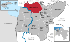
| Location of the municipality of Moormerland in the district of Leer | ||
  |
||


Moormerland is a unitary community originally formed from ten independent villages in the district of Leer in East Friesland . It is a relatively densely populated rural municipality in inner-East Frisia and in Lower Saxony , most densely in the southeast of its area, near the district town of Leer . Moormerland has 23,567 inhabitants and is the second largest municipality in the district after the district town and, after Emden , Aurich , Leer and Norden - before the cities of Wittmund , Weener and Wiesmoor - the fifth largest municipality in East Friesland. The municipal administration is based in Warsingsfehn .
The name Moormerland comes from a Frisian state community that was in this area before and during the time of the chiefs . The Moormerland was home to the family of the East Frisian chiefs Ukena , who played an influential role in East Frisian history at the beginning of the 15th century . Along with the Overledingerland , the Lengenerland and the Rheiderland, it is one of the four historical landscapes in the district of Leer, but encompassed a significantly larger area than today's municipality. The district of Oldersum is historically significant as a former trading place on the Ems , but above all as the place of the Oldersum religious discussion , which gave the impetus for the Reformation in East Friesland.
Economically, the community is characterized by agriculture, tourism and medium-sized production, craft and trading companies. The municipality is to a large extent a community of out-commuters, especially to the neighboring cities of Emden and Leer.
geography
Position and extent
Moormerland is located in the northwestern part of the district of Leer on the Ems with a shore length of about ten kilometers. The river, which mostly flows roughly in a south-north direction, curves there and turns to the west towards Dollart . Moormerland lies within the city triangle Emden-Aurich-Leer and is thus "framed" by the three largest East Frisian cities. The municipality is directly adjacent to two of these cities, Emden and Leer. Nearby major cities are Oldenburg (about 54 kilometers east-southeast) and Groningen in the Netherlands (about 62 kilometers west-southwest). The regional spatial planning program of the district of Leer assigns the main town Warsingsfehn as well as the towns Neermoor and Veenhusen the function of a basic center for the municipality.
The municipality was named after the Frisian regional municipality of the same name in the Middle Ages. In addition to the modern Moormerland, the state community also included the area of the present-day Jümme and Hesel communities and the city of Leer . The Moormerland is one of the four historical regions in the district of Leer. In addition to the Moormerland, these are the Rheiderland on the opposite bank of the Ems as well as the Lengenerland and the Overledingerland . Modern communities have also been named after the latter two since the 1970s ( Westoverledingen , Uplengen ).
The municipality extends over 122 square kilometers, which makes it the second largest in the district of Leer (after Uplengen ) and the ninth largest in East Frisia . With around 22,500 inhabitants, the population density is around 184 per square kilometer. It is thus above the East Frisian (around 148) and also above the Lower Saxony (around 166), but below the average of the Federal Republic of Germany with around 229 inhabitants per square kilometer. The largest east-west extension is about 17.2 kilometers between the border with the Samtgemeinde Hesel in the Jheringsfehn district and the border with the city of Emden near Gandersum, the largest north-south extension about 10.7 kilometers between the Fehntjer low in the north and the border to the city of Leer south of Veenhusen.
Geology and soils


The geological subsurface of the Moormerland is determined by sediments from the Pleistocene and Holocene . The municipality is characterized by the river marshes of the Ems and extensive moor areas in the eastern part of the municipality. The area of the municipality of Moormerland combines the three typical landforms of the East Frisian mainland: marshland , geest and moor . These each run roughly in a north-south direction and are in the order mentioned from west to east. The marshland lies along the Ems and has fertile young marshland in the extreme northwest of the municipality near Oldersum. Further south along the Ems there are overlooked marginal moors ( flood moors ). To the east there is a narrow strip of geest, which is partially broken through by fens . The district of Tergast in the far north-west is located on a Geest island in the middle of marshland and sloping bogs. The east of the municipality consists of raised bog , in the far north lies the river marsh of the Fehntjer low .
The soils of the municipality show the same diversity as the geological structure. Outer dikes on the Ems are still undeveloped river marsh soils, which are immediately followed by inland dyke transitional brackish marsh soils , further inland then replaced by heavy boggy marsh soils and bog marsh soils. The latter two have a high density, because in earlier centuries the finest suspended solids penetrated the farthest inland and were deposited during floods, so the granularity of the soil is very fine. Correspondingly, the broken and marshy soils are more difficult to cultivate than the brackish marsh soils. In the area around the Tergast district there is brown earth , large parts of the Neermoor and Hatshausen districts consist of podzol soils in a dry location with Ortstein underneath. The east of the municipality is formed by raised bogs and fens, almost all of which are cultivated.
The highest point in the municipality is the artificially raised, 14.8 meter high Fehntjer Mountain in Warsingsfehn. It was created in the early 1970s when sand was poured when the Sauteler Canal was dredged (see waters).
Waters


The municipality is bounded in the west by the Ems, which is already deep there . Two larger rivers are the Fehntjer Tief and the Sauteler Kanal, the sources of which are in the neighboring municipality of Großefehn. They serve to drain the low-lying areas. The Oldersum Drainage Association is responsible for this task.
While the upper reaches of the Fehntjer Tief is of natural origin and meanders to the west, the Sauteler Canal is an artificially created body of water that was created in the late 1960s and early 1970s to improve drainage. However, there were plans to build the canal a few decades earlier. The Sauteler Canal drains an area of around 20,000 hectares (200 square kilometers) and thus slightly more than 1/16 of the entire East Frisian land area. It has a length of about 23 kilometers. The canal begins a few hundred meters west of Aurich-Oldendorf in the neighboring municipality of Großefehn and flows south of the Moormerland district of Terborg with a pumping station into the Ems.
The Fehn canals of the villages Warsingsfehn, Jheringsfehn and Boekzetelerfehn branch off from the Sauteler Canal. The smaller ones are called Wieken and are too narrow and too shallow for even smaller motor boats to be able to navigate. During the peat removal of the Fehne, however, they were driven over (or grained ) with shallow boats , which carried away the cut peat. Larger fen canals such as the Warsingsfehn canal can be navigated by motor boats. The Warsingsfehn Canal is connected to the Rorichumer Tief and via the Heuwieke to the Fehntjer Tief. The Fehntjer Tief ends in Emden, from where the waterway network in the Aurich district is connected via other canals. The Rorichumer Tief ends in Oldersum and from there the Oldersumer Tief also leads to the Fehntjer Tief; there is also a passage to the Ems. The Sauteler Canal is connected to the Fehntjer Tief in the neighboring municipality of Neukamperfehn via the Neuefehn Canal, so that almost all waterways in the municipality are connected to each other and via the Fehntjer to canals in the neighboring communities. The Ems Lateral Canal , which connects the Emden port with the port in Oldersum and runs parallel to the Ems, was also artificially created.
In the municipality there is the Boekzeteler Meer, a low moor lake, the municipality borders on the western shore of the Timmeler Meer . Another, albeit significantly smaller, moor lake is the Wolfsmeer in the southeast of the municipality. At Neermoor and Veenhusen there are several quarry ponds from which sand is extracted. On the eastern edge of Tergast there are several lakes, some of which are used to obtain drinking water for the Emden municipal utilities , others have been stocked with fish and are available for anglers; some of them used to be gravel pits .
Neighboring communities
In the northwest, the municipality of Moormerland borders on the independent city of Emden , in the north on the municipalities of Ihlow and Großefehn, which are part of the Aurich district . The border to the municipality of Ihlow is mainly formed by the Fehntjer Tief , the border to the municipality of Großefehn entirely by the southern arm of the Fehntjer Tief and the Timmeler Meer and the Boekzeteler Meer , both of which are traversed by the southern arm of the Tief. In the east, Moormerland borders three member communities of the joint community of Hesel : Neukamperfehn , Hesel and, on a very short section, Holtland . The district town of Leer is located south of the municipality . The municipality of Jemgum lies on the other side of the Ems in the Rheiderland , the middle of the river forms the border.
Land use
| use | Area in ha |
|---|---|
| Building and open space | 1,202 |
| including living space | 876 |
| of which commercial and industrial space | 49 |
| Operating area | 60 |
| of which mining areas (especially sand) | 54 |
| Recreation area | 55 |
| including green area | 35 |
| traffic area | 626 |
| of which road, path, square | 583 |
| Agricultural area | 8,831 |
| of which moor | 38 |
| Water surface | 985 |
| Forest area | 178 |
| Areas of other use | 292 |
| including cemeteries | 8th |
| of it land | 166 |
| total area | 12,229 |
The municipal area is predominantly (almost 73 percent) used for agriculture. This puts Moormerland just below the East Frisian average of around 75 percent, but well above the German average of 52.3 percent. About 7.5 percent of the total area of moor merland is covered by water with drainage ditches, fen canals, deeps and inland lakes, which means that the national average of 2.4 percent water area is slightly more than three times higher. In contrast, the proportion of forest in the Moormerland is extremely below average. At 1.23 percent, it is even below the East Frisian average of 2.6 percent, which in turn is very low in a Germany-wide comparison: the proportion of forests in the total area of the Federal Republic is 30.1 percent. There are only a few smaller afforested areas in the municipality.
Community structure
The municipality of Moormerland consists of eleven localities. They are sorted below according to their number of inhabitants (in brackets) (as of December 31, 2011).
| Locality | Residents | associated districts |
|---|---|---|
| Warsingsfehn | 7593 | Warsingsfehnpolder, Rorichmoor |
| Neermoor | 4641 | Neermoor Colony |
| Veenhusen | 3898 | Veenhusen colony |
| Jheringsfehn | 2448 | - no more - |
| Oldersum | 1516 | - no more - |
| Boekzetelerfehn | 760 | Boekzeteler Hoek |
| Hatshausen | 576 | Ayenwolde, Büschersfehn, Königshoek |
| Tergast | 489 | - no more - |
| Rorichum | 424 | - no more - |
| Terborg | 109 | Sautelersiel |
| Gandersum | 89 | - no more - |
| total | 22,543 | - |
The focus of the population is in the southeast of the municipality on both sides of the motorway with the districts Warsingsfehn, Jheringsfehn, Veenhusen and Neermoor, in which around 18,500 of the municipality's 22,000 residents live. The districts of Warsingsfehn and Veenhusen in particular have grown together, there are hardly any gaps in the development. The transition from Warsingsfehn to Jheringsfehn is also fluid. Neermoor to the west of the motorway is separated from the two fends by its route. However, the areas on both sides of the motorway are almost completely built on by commercial enterprises.
In the north-west of the municipality there is a second, but much smaller settlement focus with Oldersum, Tergast, Rorichum and Gandersum. Oldersum and Rorichum have also grown closer together. In the north of the municipality, on the other hand, there are only the small villages of Hatshausen and Ayenwolde with distinctly loose buildings as well as further living spaces and large undeveloped areas, some of which are designated as nature reserves or used for agriculture. The southwest of the municipality along the Ems is also very sparsely populated, is used for agriculture and has no settlement core.
climate
Moormerland is in the temperate climate zone, mainly in the direct influence of the North Sea . In summer the daytime temperatures are lower, in winter often higher than in the further inland. The climate is characterized by the Central European west wind zone.
After the climate classification of Köppen is Moormerland is in the classification Cfb . (Climate zone C : warm-temperate climate, climate type f : humid-temperate climate, sub-type b : warm summer )
Within the temperate zone, it is assigned to the climate district of Lower Saxony flatland North Sea coast , which has a maritime character and is characterized by relatively cool and rainy summers, relatively mild winters with little snow, prevailing westerly and south-westerly winds and high annual rainfall.
The closest weather station is in neighboring Emden.
|
Monthly average temperatures and precipitation for Emden (Wolthusen measuring station)
Source: German Weather Service
|
||||||||||||||||||||||||||||||||||||||||||||||||||||||||||||||||||||||||||||||||||||||||||
Protected areas

Nature reserves (NSG) are mainly located in the northern part of the municipality. The municipality has only a very small share in the Fehntjer Tief-Nord NSG, but the lion's share in the Fehntjer Tief-Süd area . Both areas are characterized by grassland and wet meadows and are predominantly used extensively for agriculture. They are part of the FFH area Fehntjer Tief and the surrounding area and the EU bird sanctuary Fehntjer Tief . In the northeast of the municipality is the NSG Boekzeteler Meer , a low moor lake with silting zones. The Wolfmeer is a silting lake in a moorland in the southeast of the municipality. There are two other protected areas along the Ems. The Emsauen between the mouth of the Ledam and Oldersum are part of an EU bird sanctuary and serve to preserve the foreland as a breeding area for birds. The Petkumer Deichvorland NSG fulfills the same protective purpose , which extends largely in the area of the neighboring town of Emden, but to a lesser extent on the Moormerland area. The inland island of Hatzumer Sand is also part of the Emsauen protected area .
history
The municipality of Moormerland emerged as part of the Lower Saxony municipal reform on January 1, 1973 from the former independent municipalities of Boekzetelerfehn, Gandersum, Hatshausen, Jheringsfehn, Neermoor, Oldersum, Rorichum, Terborg, Tergast, Veenhusen and Warsingsfehn. The new municipality was named after the Frisian state municipality of the same name , which had been located in this area in the Middle Ages. The historical Moormerland, however, was much larger and also included most of the present-day Jümme and Hesel municipalities and the city of Leer . The history of the individual villages is much older and can be traced back to the Middle Ages.
Development of the community name
The name Moormerland is of medieval origin. It was first mentioned in writing in 1346 as the designation of origin van Moormannerlande , and in 1432 there was the name Mormer Lande . The name can be traced back to the wide raised moor areas that make up a large part of the municipality. The second Appellativum came man added, supplemented by the Herkunftssuffix -er . This merged into the shorter -mer . Moormerland (with the emphasis on the first syllable and the short pronounced "e") means land of the men from the moor .
Some place names in the municipality are formed with the generic term Fehn (or Veen , as in Dutch ), including the main town Warsingsfehn. The ending -fehn indicates that it is a moor settlement . In Low German documents from the 15th century, the word Fehn initially only means settlement in the moor , in the Moormerland area this applies to Veenhusen. It was only after the establishment of Großefehn (1633) that the word got a further, more concrete meaning in East Friesland as a name for a moor settlement that was laid out along an excavated canal, a Fehn Canal. Nevertheless, there were also moor settlements in the following period that were not laid out along a Fehn Canal and still have the name ending -fehn, in the Moormerland this applies to Büschersfehn. In general, a Fehn (also: Fehnsiedlung, Fehnkolonie) is understood to mean a bog colony along a canal. For a more precise distinction, however, the literature sometimes also distinguishes between real (with a canal) and false (without canal). With the exception of Büschersfehn, the Moormerland consists exclusively of real fen settlements.
Prehistory and early history
Oldest archaeological finds in Moormerland are Mesolithic cooking pits (about 7000 v. Chr.). They were found in 1989 during excavations in the Neermoor district on the Geest. The people of that prehistoric era were hunters, whose preferred places to stay were on the slopes between the various vegetation zones: the pine forests on the Geest and the broken forest along the Ems.
A Neolithic flint ax was found in the high moor near Jheringsfehn. The ax type is characteristic of the individual grave culture . Ceramics of the funnel beaker culture came to light during excavations in Neermoor. The farmers of the Neolithic generally settled in all parts of East Friesland except for the most inaccessible high moor areas. In the present area, this has been proven - in addition to the mentioned places Jheringsfehn and Neermoor - for those parts of the Warsingsfehn district that are located on Geestinseln.
Finds from the younger Bronze Age and the older pre-Roman Iron Age , however, have hardly been discovered in the present area. An exception are urn vessels that came to light in the Warsingsfehn area. They are to be assigned to the urn field culture, thus an epoch of transition from corpse to cremation.
In the year 12 BC The Romans first reached East Frisia under their general Drusus . A few years later, Germanicus anchored in the Amisia ( Ems ). Ceramic shards from the Roman Empire were found in Rorichum.
Early and High Middle Ages: Settlements on the Ems
In the 5th century there was a sharp decline in settlement. The reason for this could have been the rise in sea level and the resulting flooding of the marshes and the watering of the Geest. The decline in population is only noticeable in the lack of archaeological finds for the 5th and 6th centuries. After this decline in settlement, which is explained by the Dunkirk II transgression , there was renewed settlement from the 7th or 8th century. In Oldersum finds from the 7th, possibly 6th century were discovered in the village throws near the church. This find relativized the older statement of a population decline at least for the 6th century and at least for the place Oldersum. In the transition phase from the early to the high Middle Ages, the place developed into a Wik settlement , a village trading settlement with access to the high seas, as also existed at that time in Emden, Nesse or Groothusen . In the High Middle Ages there were the settlements of Gandersum, Oldersum, Rorichum and Terborg an der Ems along the river. With the exception of Oldersum, these localities were already mentioned in the Werden arable land . The village of Tergast, located on a Geest island, also existed around the year 1000.
In the Middle Ages, one of the seven Frisian military routes ran through the Moormerland region: the one from Münster to Emden. He was mentioned in the Seventeen Freedom Charts , which the representatives of the individual Frisian regions decided on at the Upstalsboom . The elections stipulate that traders enjoy protection against payment of a toll when using these long-distance trading routes. The freedoms are dated to the 11th century, but the path mentioned therein was of an older date and goes back to the 8th to 10th centuries. Coming from the south via Leer, it led to Neermoor and on to Tergast, taking advantage of the one-meter contour line between Geest and Emsmarsch. From Tergast the route continued via Oldersum along the Ems to the port of Emden.

The construction of dykes began around the year 1000. Because of the rise in sea level, in the 12./13. In the 19th century, however, the village of Neermoor was relocated further east to the Hohe Geest. In the 13th century, older wooden churches were replaced by stone buildings in the Emsdörfern and in Tergast, a town on a Geest island near the Ems. The oldest preserved brick church is the one in Tergast .
Neermoor as well as Veenhusen to the south and Rorichmoor to the north were row villages. This resulted from the geological conditions that the settlers found: a strip of geest running in north-south direction between the river marsh to the west and the moor to the east. In order to make the moors usable, drainage ditches were dug parallel to each other in the moors, in the present case in an easterly direction. Each of the settlers was entitled to a strip of bog of a previously agreed width. He was allowed to colonize this lengthwise until he hit a natural obstacle or (in the case that a moor area was reclaimed from two opposite sides) the colonate of another. However, given the resources available at the time, the length was technically limited. The use of the moors was therefore initially limited to the edge zones. The result of this process were the row villages with their so-called extensions . Two further examples of bog colonization in Upstreeken can be found in the villages of Ayenwolde and Hatshausen to the north of the raised bog zone, the colonies of which dovetailed over time because the striped fields did not run directly parallel to one another. An extensive completion of this medieval bog colonization must be expected in the 13th or 14th century at the latest.
Chief time


The storm surges of the 14th century, especially the second Marcellus flood (Grote Mandränke) in 1362, also hit the area of today's municipality of Moormerland. These storm surges and a plague epidemic in 1349/1350 led to political changes in East Frisia. Chiefs stood out among the free peasants and founded their own dynasties. The Frisian freedom of the landowning farmers, which had existed since the High Middle Ages, was gradually eroded.
In various regions of East Friesland, individual families gained an outstanding position. In the area of the Moormerland these were the Ukena. The most important son of this family, presumably from Neermoor, was Focko Ukena , who, together with other chiefs, opposed the chief family tom Brok , which was becoming more and more powerful and striving for extensive rule , and who decisively defeated them in the battles of Detern in 1426 and on the wild fields in 1427. However, since Ukena himself claimed a prominent position among the chiefs, he came into opposition to the party of the Cirksena family , which led the Freedom League of the Seven East Friesland and which in 1431 captured the castle of Focko Ukena in Leer. Ukena then fled to Münster, later to the castle of his second wife Hiddeke van Garreweer in Dijkhuizen in the Ommelanden (Netherlands), where he also died. The episode of the Moormerland chief family as the most powerful in East Frisia was therefore limited to a few years.
In the county of East Friesland
After the establishment of the county of East Friesland in 1464, the Moormerland belonged to the Leerort office . An exception was the glory of Oldersum, which retained a certain degree of autonomy within the sovereign rulership for around 170 years.

In addition to Emden, Oldersum is of great importance for East Frisian religious history - and thus for East Frisian history in general: the Oldersum Religious Discussion took place there in 1526 , a dispute between the Emden preacher Georg Aportanus (Protestant-Lutheran) and the Catholic Dominican prior Laurens Laurensen from Groningen . The minutes written by Ulrich von Dornum , the lord of Oldersum Castle , made a decisive contribution to the widespread use and rapid implementation of the Reformation in East Frisia. A Reformed pastor in Tergast is already secured for 1528, and then also in Gandersum for 1552. The pastor of Rorichum himself took part in the Oldersum Religious Discussion, and his congregation also turned to the new direction.
After the glory of Oldersum had developed favorably in the 15th and 16th centuries and had become a market town, the rulers' high indebtedness led the city of Emden to buy up the glory along with the villages of Gandersum, Tergast, Rorichum and Simonswolde in 1631. When Emden acquired several splendid assets in the east of the city, it was primarily important to secure the traffic routes.
During the Thirty Years' War , East Friesland was not the scene of fighting, but it was used by troops as a rest room . Three times (1622–1624, 1627–1631 and 1637–1651) foreign troops moved into East Friesland, which also affected the present area. The region was particularly hard hit by the occupation by the Mansfelder . The two following occupations also meant burdens through contributions. The occupiers from 1627 to 1631, however, imperial troops under Tilly , “kept discipline and avoided excesses” as did the Hessian troops billeted from 1637 to 1651 under Wilhelm V of Hessen-Kassel . Materially, too, the situation was different under the two occupations than under Mansfeld: Although contributions were collected, these were also spent in the region. During the war, the plague also broke out in East Frisia , but deaths for the area in question are not documented.
Moor colonization from 1647
The moor colonization by Fehne in the area of today's municipality Moormerland began in the 17th century. Boekzetelerfehn (1647) made the start, making it one of the oldest fen colonies in East Frisia. It was created 14 years after the founding of the first East Frisian fen colony in Großefehn. In Boekzetelerfehn, however, colonization did not proceed according to the later ideal-typical framework, in that a drainage channel was dug straight into the moor. Rather, the first settlers built the main Fehn Canal on the natural edge of the moor, and the canal was accordingly curved. Only later did they switch to driving the canal straight into the moor. The neighboring Hookster Fehn was built in 1660. It got its name because it is in the corner (East Frisian Low German hoek or hook ) between Boekzetelerfehn and Neuefehn. The Hookster Fehn was significantly expanded from 1754 and named after the Aurich government director Sebastian Jhering (1700–1759); Jheringsfehn still bears this name today.

In order to improve the removal of the peat from the Fehnen to Emden, the Fehntjer Deep was artificially extended to the west from a point a few kilometers north of Oldersum (near the Monnikeborgum farm) in the 17th century . Until then, the low had flowed via Oldersum to the Ems, since then it has ended in Emden. The last natural section has since been called Oldersumer Sieltief.
From the early 18th century, the moor brand culture was reintroduced in East Friesland from Hatshausen. It is true that moors were cultivated by burning in earlier centuries; however, this method had been forgotten. The pastor Anton Christian Bolenius, who worked in Hatshausen from 1707 to 1716, reintroduced the method from the Netherlands in East Frisia.

The Christmas flood of 1717 caused great damage to the East Frisian coast. However, the Moormerland as part of the Leerort office was less affected than the coastal stretches in the north of East Frisia. In the entire Leerort office and in the glory Oldersum, a total of six deaths were to be mourned, compared to, for example, almost 600 in the Berum office . However, almost 130 horses and more than 800 cattle, sheep and pigs drowned in the Leeroort office, whose part closest to the coast was the Moormerland. According to a contemporary survey by the predicant Jacobus Isebrandi Harkenroth, 149 houses were partially destroyed and twelve completely destroyed.
Warsingsfehn was laid out from 1735, but the foundation date is the signing of the long-term lease agreement with Fehn's founder Gerhard Warsing on November 16, 1736. Warsing, who lived on Gut Sieve near Tergast, had the Warsingsfehn Canal dug in a south-easterly direction, with which the approx Hectares of high moorland were drained and developed. Until 1779 his son Hermann leased about 122 hectares. As usual in the feudal settlements, the land was passed on to sub-tenants who paid taxes and were responsible for the construction of the branch canals, known as Inwieken . They bore the brunt of the colonization of the moors.
As in the other East Frisian Fehn towns, shipping developed into a further branch of business for the Fehntjer in the following 200 years, alongside peat extraction and - mostly modest - agriculture. The basis of this profession was the independent removal of the peat to the sales areas, primarily the cities of Emden and Leer as well as the marshes.
Prussian from 1744 to 1806
After the last Count of East Friesland, Carl Edzard , died childless at an early age, East Friesland fell to Prussia in 1744 due to a prospect that had existed since the end of the 17th century . The Moormerland was occupied twice by foreign troops during the Seven Years' War . Troops of the French generals Dumourier and d'Auvet occupied the area in 1757, troops of the Marquis de Conflans in 1761. The occupiers demanded payments in kind and contributions .
In the second half of the 18th century, more than 80 new peatland colonies were established in East Frisia . New villages were also established in the Moormerland, including the Neermoor colony about three kilometers south of the eponymous mother town in 1764 and the Veenhusen colony west of the mother town in the same year. 1772, after the signing of Urbarmachungsediktes by Frederick the Great (1765), came Büschersfehn southeast of added Hatshausen. The central places of that time, when merchants and craftsmen concentrated, were Neermoor and especially Oldersum.
Like many other East Frisian parishes, the Hatshausen parish turned to pietism in the second half of the 18th century . Pastor Georg Siegmund Stracke, who worked in Hatshausen from 1797 to 1814, became the head of the Senfkorn Mission Society , the first missionary society of a Protestant church in Germany. It was founded in Hatshausen and developed into a “mission preschool for prospective missionaries before they were sent to the African and Oriental mission areas via London”.
From the Kingdom of Holland to the Kingdom of Hanover (1806–1866)

The municipality and all of East Frisia came to the (Napoleonic) Kingdom of Holland after the double battle of Jena and Auerstedt . This was in turn integrated into the French Empire in 1810 . After the Wars of Liberation, East Frisia became Prussian again for a short time. However, the states participating in the Congress of Vienna had agreed to swap territories, which also affected East Frisia. It became part of the Kingdom of Hanover and remained there until its dissolution after the German War of Unification (1866).
In the first half of the 19th century, the importance of shipping for the Fen residents steadily increased. In addition to inland shipping, which essentially consisted of the transport of the peat to the cities of Emden and Leer as well as the surrounding marshland areas, the importance of maritime traffic also grew, although the actual home port could naturally not be the Fehn due to the size of the Fehn canals. Rather, when the ships were not on the move, they were in the ports on the Ems. This applied to Emden, but also to Oldersum, where shipyards were also located. In 1751 there were just 35 inland vessels in the three feudal towns Boekzetelerfehn, Jheringsfehn and Warsingsfehn, but by 1816 the total number of vessels had risen to 108, of which 81 were inland vessels and the other sea vessels. The turn to maritime traffic, which mostly moved along the coast, arose initially from the expansion of the peat sales areas. During these voyages, however, the shipowners gradually took other goods on board, and over the decades this became an important trade for the Fehne. In 1846 the Kingdom of Hanover founded a seafaring school in Timmel , only a few kilometers from the three Fehnorten, which existed until 1918.
The connection to the national railway network took place in 1854 with the completion of the Hanover West Railway between Emden and Leer. Railway stations were built in Neermoor and Oldersum. The section between Emden and Neermoor cost around 400,000 Reichstaler, the section between Neermoor and Leer around 290,000. This made the construction section between Emden and Neermoor - due to the soft marshland - the most expensive section between Emden and Rheine .
In the middle of the 19th century, Neermoor was one of the East Frisian centers of the movement of the Old Reformed believers , who, starting from the Netherlands, split off from the Reformed Church because it seemed too liberal to them.
Empire

The expansion of the infrastructure was continued in the German Empire. So from 1870 the road from Neermoor to Timmel (today's Landesstraße 14) and in 1876 the road from Oldersum to Aurich (today's L 1) was built. In the years 1894-1897 the Ems Lateral Canal was built as a secondary canal of the Dortmund-Ems Canal , because the heavy towing that was customary at the time in stormy weather conditions the swell at the height of the Dollart, especially when entering and leaving the Emder Harbor, had not grown.
The current municipal area has been divided into three districts since the district reform of 1885: the north-west around Oldersum belonged to the district of Emden , the north-east around Jheringsfehn and Hatshausen to the district of Aurich, and the most populous south around Neermoor and Warsingsfehn to the district of Leer.
In the second half of the 19th century, many Moormer countries emigrated to the USA. This led to a decrease in the number of inhabitants and later to a slower increase. A major cause was the increasing coal production, which gradually replaced peat as fuel. In addition, many Fehntjer boatmen with their wooden sailors could only do little to oppose the iron-hulled ships on the high seas and suffered from the increasing competition from the railways in inland navigation.
The number of ships domiciled in the Fehn shows the decline. At the height of Warsingsfehntjer shipping in 1882, there were 102 ships there, 86 of them inland and 16 sea-going vessels. In Jheringsfehn there were 54 ships at the same time, 39 of them inland vessels and in Boekzetelerfehn only 19 ships, 16 of which, however, went to sea. In Jheringsfehn and Boekzetelerfehn the highest number of ships was registered as early as the 1860s. Together, the three Fehnorte came to 175 ships in 1882, 128 of them inland vessels. In 1900 the total had dropped to 114. Of these, however, 94 were barges and only ten were seagoing vessels. The Fehntjer boatmen essentially returned peat to the area, albeit at a lower level than in the 19th century.
However, shipping continued to be of great importance as a labor market. Previously self-employed boatmen were hired by shipowners in other places, namely in Emden and Leer, but also beyond. The Emden herring fishery, for example, as well as shipping companies operating overseas were important. Until the 1960s, the shipping companies recruited many of their captains, helmsmen and sailors from the feudal settlements, where a professional tradition as seafarers had emerged over the decades.
Weimar Republic
It is known from most of the villages in the Moormerland that resident groups were formed in 1919 to protect themselves. The background was the so-called “bacon removals” by workers who, under threat of violence and - in individual cases - also using them on farms, supplied themselves with food.
The voters in the individual communities that make up the Moormerland community today, voted more radically as the Weimar Republic lasted longer. In the municipality of Hatshausen, for example, in the elections to the National Assembly in 1919, more than 70 percent of the voters voted for liberal parties, only 10.6 percent for the DNVP . In the Reichstag elections in July 1932, the NSDAP received 86.1 percent of the vote. In other places this shift was less pronounced, but just as noticeable. There were also strong left forces in the northwest of the municipality and in the feudal settlements. In the first Reichstag election in 1919, the SPD won 46 percent in Oldersum. In the November 1932 election, the SPD was 22.4 percent. The KPD came to 16.9 percent. NSDAP and DNVP were 33.2 and 18.8 percent, respectively. The state-supporting parties of the Weimar Republic together received only a third of the votes. In the opinion of the historian Albert Janssen, the strong position of the workers' parties SPD and KPD in comparison to the whole of East Frisia was “certainly a consequence of the special professional and social structures that existed in the Fehngemeinden. An extraordinarily large number of seafarers, shipyard workers and small colonist families lived there. ”Oldersum not only had a small port and a shipyard, in the northwest of what is now the municipality, commuters to the port city of Emden also played a role.
In the course of the dissolution of the district of Emden in 1932, in addition to Borkum, the places Oldersum, Gandersum, Tergast and Rorichum became part of the district of Leer. The places, with the exception of Borkum, all parts of the former glory Oldersum, have been part of the Leer district ever since.
National Socialism and World War II
The NSDAP gained a foothold in the district of Leer late, in contrast to the East Frisian neighboring districts of Wittmund and Weener (still independent until 1932) and parts of the district of Aurich. This was also reflected in the last local elections on March 12, 1933. Although the National Socialists emerged from the elections as the strongest force everywhere in the municipality, they nevertheless lagged behind the results of their strongholds. Again it was the north-west of the municipality and the feudal settlements in which the NSDAP performed below average in a comparison across East Frisia. In Tergast, the National Socialists were only very slightly ahead of the SPD (36.3 to 35.8 percent), and in Oldersum, Neermoor and Warsingsfehn the two workers' parties together achieved results of more than 30 percent.
The takeover of power by the National Socialists initially concentrated on the East Frisian cities, then also on the district offices. However, the District Administrator Hermann Conring in Leer kept this function. He played an active role in the persecution of politically dissenters, especially communists, which began immediately after the seizure of power, but in some cases also campaigned for the release of prisoners who had been deported to concentration camps. While he advocated the release of the Petkum communist Walter Spiegel, he spoke out in favor of the further imprisonment of the Neermoor communist Gerhard Rabenberg and justified this as follows:
“Rabenberg has been the leading force of the KPD in Neermoor for years and was in close contact with the communist leadership in Emden and Bremen. The greatest objections are to the lifting of protective custody, as it can be assumed that Rabenberg will immediately become communist again after his release. "
At the end of July 1933, 30 communists from the district were in concentration camps, mainly in the nearby Börgermoor , where at least four people from the Moormerland were also imprisoned.
In their pursuit of sole power, the National Socialist combat troops did not stop at (former) spiritual companions either, as is documented in a report by the Leer district administrator:
“In the village of Oldersum there have been disagreements for a long time between the SA and the Stahlhelm, which occurred on the night of July 22nd to 23rd. Js. [1934] came to discharge. Four younger SA men physically assaulted several members of the Stahlhelm on the way home from a restaurant to their apartment and smashed their window panes afterwards. "
Similar attacks have also been reported from Neermoor. District Administrator Conring got in touch with local NS figures to hold the SA men accountable. Like the local Sturmführer, they were given a temporary leave of absence. There were further attacks in the months that followed.
In Oldersum, the Jews who had been resident for around 300 years, as in the rest of East Frisia, had been subjected to reprisals since 1933. From April 1st, SA guards stood in front of Jewish shops to monitor their boycott . During the pogrom night of 1938 , Jews from Oldersum, Warsingsfehn and Jheringsfehn were also deported. They were taken via Leer to Oldenburg and finally to Sachsenhausen concentration camp , but initially returned from there later. In 1938/1939 up to 250 Jews from Vienna were used as forced laborers to raise the dike on the Ems in East Frisia . They were mostly people with a higher education; In addition to four other locations, they were also housed in a camp in Nüttermoor , and there was hardly any contact with the local population. The last citizens of the Jewish faith were deported from Oldersum in 1940. It is known that 30 people whose place of birth or place of residence were Oldersum were murdered in concentration camps. Nine people whose place of birth or place of residence was Warsingsfehn were killed in the concentration camps of Auschwitz , Sobibor and Kauen .
During the war, an alternative camp for bombed-out Emden families was set up in Neermoor . During the war, the area of the municipality of Moormerland was initially not affected by air raids, apart from a few bombs that were originally targeted for other purposes (namely Emden). After the allied troops on 28/29. Having conquered Leer in April 1945, they advanced north along the Ems to Emden. In order to delay the advance of the 9th Canadian Brigade, the railway bridge over the Rorichumer Tief, on May 3rd the road bridge in Rorichum and on May 4th the bridge over the Oldersumer Sieltief were blown up on the night of May 1st . Gandersum was shot at from the opposite bank of the Ems and the church was damaged. Rorichum also came under fire and recorded building damage. The Volkssturm was mobilized in Oldersum, but it was no longer involved in war operations. After the Emder had agreed with the Canadian commander to hand over the city, the Volkssturm members were released. On May 5th, Emden was occupied by the Canadians, so the war was over on Moormerland territory.
post war period
After the war, numerous expellees from the eastern regions of the German Empire were also taken in in the communities of today's Moomerland. The town of Oldersum, for example, grew by almost 50 percent; the proportion was similarly high at times in Tergast. In other districts the increase was lower, in Warsingsfehn it was around ten percent.
The district of Leer - and within it the municipality of Moormerland - took in the largest number of people among all districts in Lower Saxony who were already unemployed or unemployed in the eastern regions. The proportion of people over 65 was also higher than the average in Lower Saxony. In contrast, the district of Leer recorded the lowest proportion of male refugees from the East between the ages of 20 and 45 of all districts in Lower Saxony. In the years that followed, this made a major contribution to the fact that the unemployment figures were well above average in the early 1950s and that the emigration of refugees to more prosperous regions of Germany was correspondingly high.

The structural change in agriculture affected all of East Frisia after the war. The Moormerland was also affected: the number of people employed in agriculture fell significantly as a result of increasing mechanization and rationalization. The surplus of labor was partly absorbed by the fact that new employment opportunities arose outside the community since the late 1950s, for example from 1957 through a branch of the office machine manufacturer Olympia in Leer with at times 2700 employees or from 1964 through the establishment of the Volkswagen factory in Emden . The Moormerland became a commuter area. The unemployment figures remained (in some cases far) above average.
As part of the Lower Saxony municipal reform, the merger of the previous municipalities of Boekzetelerfehn, Gandersum, Hatshausen, Jheringsfehn, Neermoor, Oldersum, Rorichum, Terborg, Tergast, Veenhusen and Warsingsfehn to form today's municipality of Moormerland was completed on January 1, 1973. In the villages in the northwest of the municipality, which until 1932 still belonged to the district of Emden, an incorporation into Emden was also heatedly discussed, but ultimately rejected by a majority in the councils. As recently as the summer of 1972, all the parishes involved in the “unification process” had campaigned to found a joint parish in which they would have remained independent as parishes. This was favored not least because several places (Hatshausen with Ayenwolde, Jheringsfehn, Boekzetelerfehn) had belonged to the Aurich district since 1885 and when they were incorporated into Moormerland, the district also changed. The state of Lower Saxony, on the other hand, was in favor of a unified municipality from the start . Surprisingly, the council of the municipality of Veenhusen suddenly voted against the establishment of the integrated municipality. Since the consent of all congregations would have been necessary, only the formation of a unified congregation came into question. However, some other communities, especially Jheringsfehn and Boekzetelerfehn, blocked this. In response to the threat from the district of Leer that in the event of a disagreement, the communities would be forcibly brought together without their being able to exert any influence, these two communities finally bowed. The seat of the municipal administration was controversial until the end: Both Neermoor and Warsingsfehn made corresponding claims. Ultimately, the choice fell on the much younger but larger district of Warsingsfehn.

After the merger to form the municipality of Moormerland, the infrastructure was further expanded. This is how the new town hall of the municipality was built in Warsingsfehn, as was a school center (secondary and secondary school). A shopping center was built in the immediate vicinity of the school and town hall. In Warsingsfehn, several fen canals were filled in in the early 1970s, including the sand dredged up when the Sauteler Canal was excavated. This was done on the one hand for reasons of cost, because the rows of settlements on both sides of the Fehn canals could now only be reached with one supply line instead of two previously. On the other hand, the streets could be made wider to accommodate the increasing traffic. However, Warsingsfehn thereby largely lost its original fehn character. Ten so-called Inwieken , branch canals of the main Fehn Canal, were filled in. This created around six kilometers of new road.
The community continued to suffer from above-average unemployment. In the mid-1980s unemployment rates of more than 20 percent were recorded in the Leer employment office, with the peak in 1984 (23.1 percent). At that time, the district of Leer temporarily had the highest unemployment rate in the Federal Republic. In addition to layoffs at the Emden shipyards, the cause was the closure of the two largest employers in Leer, the Olympia factory and the Jansen shipyard.
The infrastructure has been expanded over the past three and a half decades. The construction of Autobahn 31, which began in the community area in the 1970s, was provisionally completed in the early 1990s with the closing of the gap between Veenhusen and the Leer triangle. At present (as of 2012) hard shoulders are being added, which were initially not installed during construction. Between 1998 and 2002, which was at Gandersum Emssperrwerk established that the river upstream hinterland at first, to protect storm surges on the other damming the Ems near overpasses of cruise ships serving, Meyer Werft possible. The municipality has also invested in promoting tourism in recent years.
Population development

A systematic recording of the population by the authorities took place in East Friesland since the beginning of the Prussian period (1744). However, official figures for individual villages are seldom transmitted from that time, so local history research is often based on church sources.
Up to the second half of the 19th century, the population increased particularly in the Fehndörfern, whereas the villages in the Marsch had already recorded a decline in the first half of that century. This was due to the amalgamation of farms, which meant fewer employment opportunities not only for farmers but also for agricultural workers. The storm surge in 1825 also contributed to the decline. In the second half of the 19th century, all parts of the community emigrated to the USA.
After the Second World War, many refugees from the east and displaced persons were taken in, which initially meant a significant increase in population. Due to the poor labor market, however, many of the newcomers as well as long-established residents migrated to prosperous regions of Germany in the 1950s. In the 1960s, the " economic miracle " also reached East Frisia. The communities of the Moormerland grew through the designation of new building areas.
After the formation of the municipality of Moormerland, the number of inhabitants increased only slightly up to the end of the 1980s, to which the emigration to other regions in view of the high unemployment figures in the 1980s also contributed. With an improvement in the economic situation and thanks to the influx of new citizens from the new federal states and repatriates, the community grew significantly in the 1990s. More recently, retirees from other regions of Germany who are spending their retirement years in East Friesland have also played a role. In 1993 the number of inhabitants exceeded the 20,000 mark, and in 2002 the 22,000 mark. Since then, the population has been consistently over 22,000 with the highest population of exactly 22,500 in 2008.
The signpost municipality of Bertelsmann Foundation predicts the community a stable population by 2030: According Moormerland would continue to be more than 22,000 inhabitants at something. The Lower Saxony State Office for Statistics, on the other hand, assumes a decline in the number of inhabitants for the entire district of Leer by 2030 (from around 165,000 to around 152,000), but does not provide any forecasts for individual municipalities.
|
|
|
|
religion


In the Middle Ages the churches were under the provost vacancy in the diocese of Münster . In the course of the Reformation , the communities turned to the new creed as early as the 1520s (Veenhusen followed around 1540). Since then, Moormerland, like all of East Frisia, has been shaped by Protestants . It is located in the transition area between the traditionally Lutheran and Reformed areas. The east is more Lutheran (parishes of Hatshausen, Jherings-Boekzetelerfehn and Warsingsfehn), the west is more reformed (parishes of Veenhusen, Neermoor, Neermoorpolder, Rorichum, Tergast, Oldersum and Gandersum). The Lutheran parishes belong to the Leer parish with a total of 19 parishes and around 40,000 members. The Reformed parishes are part of the Synodal Association of Southern East Friesland with 23,000 parishioners in 17 parishes.
Evangelical Free Church Christians , also known as Baptists , have their community center in the Veenhusen district. Its history dates back to 1857. Initially, the Baptists in Neermoor and Warsingsfehn met for irregular services; later the skipper Jan Saathoff made a room available in his house in which regular Sunday meetings began. Only in 1956 was a separate church consecrated on Königsmoorstraße in Veenhusen. In 1968 the community center was expanded; In 1983 the Evangelical Free Church Congregation Veenhusen, until then a branch congregation of the Baptist congregation Leer, became independent. On October 31, 2004, the Veenhuser Baptists moved into their new church in the vicinity of the old parish center.
Other free churches in Moormerland are the Protestant, old reformed parish of Neermoor, the Pentecostal parish in Jheringsfehn and the Christian parish of Moormerland in Warsingsfehn, which is shaped by the tradition of the Brethren movement .
Roman Catholic Christians have their spiritual center in Oldersum. This is where the parish of the Assumption of Mary is located, which forms a parish community with the Catholic parishes of Leer and Weener.
Statistical data on the number of members of other faiths, such as Muslims , are not available. The closest mosque is the Eyup Sultan Mosque in Emden.
politics

Like East Friesland as a whole, the community has been a stronghold of the SPD for decades. The Social Democrats currently have a relative majority of the seats in the local council and also provide the mayor. Only from 1999 to 2006 did an independent candidate win the mayor's office for himself. The SPD candidates also prevail in state elections, whereas the Bundestag constituency (see MPs) has been won over by CDU candidates due to its structure since it was set up. In the case of federal elections, however, the (absolute or relative) majority for the Social Democrats results in Moormerland.
In the 1949 federal elections, the SPD achieved a relative majority everywhere with the exception of the Terborg district, but in 1953 the result turned: except for Gandersum and Jheringsfehn, the Christian Democrats won in the individual communities of the Moormerland. In contrast to the rest of East Frisia, the CDU in the Leer district was organized at an early stage and achieved the best results within the region at the time. While the CDU and SPD were roughly equal in the 1969 election, the "Willy Brandt election" in 1972 meant record values for the Social Democrats in East Frisia in general and also in Moormerland: With the exception of Terborg and Hatshausen, the SPD achieved an absolute majority in the individual communities. In the decades that followed, the Social Democrats kept a very clear lead in the municipality, including in the last three federal elections in 2002, 2005 and 2009. However, the Social Democrats suffered significant losses in 2009: They only achieved 38.4 percent compared to 56 percent four Years before. Nevertheless, the SPD remained the strongest party.
Municipal council
The municipality council of the municipality of Moormerland consists of 34 councilors. This is the specified number for a municipality with a population between 20,001 and 30,000. The 34 council members are elected in local elections for five years each. The current term of office began on November 1, 2016 and ends on October 31, 2021.
The full-time mayor Bettina Stöhr (SPD) is also entitled to vote in the municipal council.
The last local election on September 11, 2016 led to the following result:
| Political party | Share of votes | Seats 2016 | Seats 2011 |
|---|---|---|---|
| SPD | 47.5% | 16 | 17th |
| CDU | 34.6% | 12 | 11 |
| Green | 8.1% | 3 | 4th |
| left | - | - | 1 |
| FDP | 2.0% | 1 | 1 |
| fair wind | 4.3% | 1 | - |
| Voting Community Moormerland (WML) | 3.5% | 1 | - |
In the 2016 local elections, the turnout of 52.4% was below the Lower Saxony average of 55.5%. For comparison - in the previous municipal election on September 11, 2011, the turnout was 47.7 percent.
mayor
The full-time mayor of the Moormerland community is Bettina Stöhr (SPD). In the last mayoral election on May 25, 2014, she was elected with 57.0% of the vote. The turnout was 50.8%. Stöhr took up office on November 1, 2014 and replaced the previous incumbent Anton Lücht (SPD).
Since the merger to form the large community of Moormerland in 1973, this office has been held by: Harm Weber (SPD, 1973–1991), Herbert Welzel (SPD, 1991–1993), Anton Lücht (SPD, 1993–1999), Heinz Palm (independent, 1999–2006 ) and Anton Lücht (SPD, 2006-2014).
Representatives in the Land and Bundestag
Moormerland is part of the state constituency of Leer / Borkum . 15 parties ran for the state elections in Lower Saxony in 2017 . Five of them had put up direct candidates. The directly elected MP is Johanne Modder ( SPD ).
Moormerland belongs to the Bundestag constituency Unterems (constituency 25), which consists of the district of Leer and the northern part of the district of Emsland. The constituency was redesigned for the 1980 federal election and has remained unchanged since then. So far, only representatives of the CDU have prevailed as direct candidates in this constituency. The constituency is represented in the Bundestag by the directly elected CDU MP Gitta Connemann from Leer. No party candidate from the constituency entered the Bundestag via the parties' list.
coat of arms
Blazon : On a silver shield base, in it two blue wavy strips, in silver under two red tin towers with two loopholes each and an open gate a blue single-masted ship with blue sails and a silver sword; the sign is crowned with the black lettering "Moormerland".
The coat of arms was introduced by the Moormerland municipal council on September 16, 1975. It adopts stylistic features from the coats of arms of the three communities Warsingsfehn, Neermoor and Oldersum, which had previously had a coat of arms. The waves below are taken from the Oldersum coat of arms, symbolizing the proximity to the Ems. The ship, which is an East Frisian Tjalk , is taken from the Warsingsfehntjer coat of arms and represents the centuries-long shipping tradition on the Ems and on the Fehnen. The two castle towers come from the Neermoor coat of arms and are reminiscent of the castle that once stood there. However, since there were two castles in Oldersum in earlier times, but not in the other districts except Neermoor and Oldersum, the two towers could also stand for the two “castle towns”. The coat of arms is based on a design by the Leer heraldist Ebo Pannenborg.
Town twinning
Since 1990 there has been a partnership between Moormerland and the Mecklenburg town of Malchow , which is also located in a water-rich area. In addition to local politicians, members of the home associations also visit each other.
The partnership goes back to a contact of the then Moormerland mayor Harm Weber to members of the round table in Malchow in 1989. As a result, various contacts developed between the residents of the two municipalities, which led to the partnership being sealed on September 11, 1990.
Culture and sights
Churches and organs


Since the river marshes of the Ems were settled much earlier than the moor areas in the east of the municipality, the much older churches are also located in the villages near the river. Some Reformed churches date back to medieval times and were built as single-nave hall churches. In Boekzetelerfehn, the cemetery of the Coming Boekzetel is between three farms. They belonged to the order house of the Order of St. John , whose coming was first mentioned in 1319. However, the soil finds so far have not been very productive.
The Tergaster church was in the 13th century on a mound built and is the oldest Moormerlands. The original apse and the vault are no longer there; the portals on the long sides are bricked up, as are the window niches on the north wall. Architecturally unique in East Frisia is the rood screen built in around 1400 with 15 pointed niches over four large round arches. Gerd Sieben Janssen created the organ in 1839/40, half of which has been preserved, while the rest was faithfully reconstructed by Winold van der Putten from Finsterwolde in the Netherlands in 1999 and 2000. The factory was originally located in Neustadtgödens and was sold to Tergast in 1939.
The Veenhuser Church originally stood on the nearby Emsinsel Osterwinsum. When the course of the river changed there, the church was demolished in 1283 and rebuilt in Veenhusen. The organ, built by Johann Gottfried Rohlfs in 1801 and 1802 and largely preserved, has eight stops on a manual and attached pedal. The old free-standing bell tower gave way to a west tower in 1869. When the center of the village moved further and further east in the course of the progressive cultivation of the bog, a new church was built in 1984 in what is now the center of the village. For a while, services were held in the school, as the way to the old church was too far for the residents of the new colony.
The Nicolai Church in Rorichum also dates from the 14th century , a one-room hall without apses, the bell tower of which is even older. There is the Petri bell, cast in 1497, which is the largest medieval bell in East Frisia with a diameter of 125 centimeters. It comes from Gerhard van Wou , one of the most important bell founders of the Middle Ages. The one-manual organ with seven registers was built by the Rohlfs brothers between 1867 and 1869 and has largely been preserved. Also on the terp is the old pastorate from 1791, which was built as a residential house with a Gulf barn on the site of the late medieval stone house. Together with the former school building, the four buildings on the mound form an unusual ensemble.
The late Romanesque Gandersum Church also dates back to the 14th century, but was thoroughly rebuilt. An east extension in the form of an apse or a choir was demolished at the end of the 18th century; the furnishings were replaced during further renovations. After the church suffered from artillery fire in 1945 and the roof collapsed, only the outer walls remained. It was rebuilt between 1958 and 1962. The small organ with five stops goes back to a house organ from the 18th century. When the church was closed around 1938, the instrument was transferred to the Emden Swiss church and thus survived the destruction of the Gandersum church. To reopen the organ, it was returned and extensively restored and reconstructed by Winold van der Putten and Berend Veger in 1990/91.
The reformed church in Neermoor was built in 1797 as a rectangular hall church. In 1875 the west tower was increased to 45 meters and three floors. The most valuable piece of furniture is the organ by Hinrich Just Müller from 1798, which has largely been preserved in its original form. The pulpit with carvings and turned corner pillars comes from the previous building and stands on a brick pedestal. It was probably created by Frerick Albers.
The parishes in Hatshausen and Ayenwolde built the Maria Magdalena Church in 1783 on the borderline between the two places, which runs axially through the door, tower, altar and pulpit. The bell tower with a Welscher dome on the south side, which also serves as the entrance portal, is dated to 1808. The pulpit was taken over from the previous church from 1680. From the organ, which was completed by Johann Gottfried Rohlfs after the death of Johann Hinrich Klapmeyer in 1793, only the historical prospectus has survived. Behind it is a new work by the Alfred Führer company (1975/76) with five registers on one manual.
The neo-Romanesque Jheringsfehner church from 1864 stands on the border with Boekzetelerfehn in a similar way . A year later the Old Reformed Church was built in Neermoor , which has only twelve pews and is one of the smallest church buildings in East Frisia.
Profane structures


There are historic windmills in the districts of Neermoor and Warsingsfehn. The mill in Neermoor dates back to 1884 and was in operation until 1989, albeit at last only with motor power, as the blades and cap were removed in 1964. A comprehensive renovation began in 2000. The Warsingsfehntjer mill was built as early as 1811/12. Its wing mechanism was also dismantled in 1967, after which the miller continued to operate it for a few years with an electric motor. The mill cap was replaced in 1994 and a gallery was added in 1996.
Residential houses from past centuries in clinker brick, which is typical for the region, as well as Gulfhöfe are everywhere in the municipality, whereby the Gulfhöfe der Marsch are mostly much larger than those on the Geest or in moor areas. The business section of Hof Janssen in Ayenwolde can also be visited from the inside by prior arrangement. There are a large number of historical bascule bridges in the fen towns. The Ems Barrage near Gandersum , which was completed in 2002, is an outstanding, recent technical structure in the municipality . The visitor facilities are visited by an annual average of around 10,000 people.
In the course of village renewal programs , old buildings were rescued in several villages in the past, even if a large number of old houses had previously been demolished. In the Warsingsfehn district, not only were old houses demolished in the course of the expansion to the center of the community, but several small Fehnseitkanals (so-called Inwieken ) were also filled in to build roads on these routes. In Jheringsfehn, however, the structure of a Fehnort can still be seen.
Museums

The local museum of the community, "Heitens Huus", is located in the main town of Warsingsfehn across from the windmill. In April 2011 a rope museum was opened in Oldersum. The construction of the museum cost the Moormerland community around 150,000 euros. It represents the history of this traditional handicraft, because for more than 100 years ropes from natural fibers were made in Oldersum, from small cords for cattle to ropes for mooring ships.
Regular events
The regular events mainly include those in the musical field. Concerts are given regularly at the Phoenix Youth and Culture Center in Rorichum. There are choirs and orchestras in most of the districts of the community and they regularly organize concerts there. Since 2015, a rock concert has been organized every year on the first weekend in November in Warsingsfehn. Local bands play for children with cancer from the region at the November Rain benefit festival .
There are also a number of traditional events such as rifle festivals and folk festivals, but these have no significance beyond the local context. Every year in May, the Schollentage takes place at the Oldersum Harbor , with which the tradition of fishing is remembered, and exhibitions are occasionally shown in a historic fen house called Heitens Huus . Apart from that, the overpasses of the Meyer Werft cruise ships down the Ems are worth mentioning. Although it is not an organized event, the event attracts hundreds of onlookers to the Moormerland Emsdeich every time.
language

In Moormerland, East Frisian Platt is spoken in addition to High German . Due to the influx of Dutch religious refugees after the Reformation , the Dutch language , which was mainly introduced by the pastors, was also widespread , at least in the reformed west of the parish area. However, it declined sharply in the 19th century, when East Frisia culturally oriented itself more towards Germany and the Reformed pastors were trained in German-speaking areas. In 1936 the Dutch language was banned from the services of the Old Reformed . Today, Dutch hardly plays a role, apart from strong sprinkles in the local dialect .
The Low German is anchored in the community. There are Low German church services and weddings are sometimes held in Low German .
Sports
In the larger districts of the community there are universal sports clubs, the largest of which is SV Warsingsfehn with around 1250 members. Others are VfL Jheringsfehn, VfL Fortuna Veenhusen, TV Moormerland (in Veenhusen), TV Oldersum, SV Concordia Neermoor and SV Tergast. Other clubs operate individual sports, including a local section each of the anglers' club Leer and the district fishing association of East Friesland, the yacht club Unterems in Rorichum and another boating club based in Neermoor. The Frisian sport of Boßeln , in which a ball has to be thrown over a specified distance with as few throws as possible, is operated as a competition in three clubs. There are also sport shooting and riding clubs as well as a cycling and hockey club.
Economy and Infrastructure
The economy of Moormerland is characterized by medium-sized companies, so there are no large companies with more than 500 employees and the community is hardly industrialized. Agriculture plays an important role, especially in the north and west of the Moormerland. The community has two larger industrial areas on either side of the Neermoor motorway junction and another industrial area close to the motorway in Oldersum. The retail trade is concentrated in the two largest districts Warsingsfehn and Neermoor, and to a lesser extent in Oldersum and Veenhusen.
Data on unemployment in the municipality are not collected. In the Leer division of the Employment Agency, which includes the district of Leer excluding Borkum, the unemployment rate in December 2015 was 6.3 percent. It was 0.4 percentage points above the Lower Saxony average.
The Moormerland is an out- commuter community . 1257 in-commuters (as of 2006) from other municipalities compared with 4838 out-commuters; that results in a negative balance of 3581. Commuters are mainly employed in the neighboring towns of Leer and Emden. 6101 Moormerländer had an activity subject to social insurance, in the community itself there were 2520 jobs subject to social insurance.
Around one percent of employees work in the agricultural sector. The total number of people working in agriculture is, however, much higher, since the mostly self-employed farmers and their helping family members do not appear in these statistics. In the manufacturing industry, 29 percent, in trade, hospitality and transport, 21 percent of the employees subject to social security contributions. 49 percent of employees work in other service occupations.
Agriculture


In 2005, 179 agricultural holdings cultivated an area of 8637 hectares in the municipality. The average farm size was 48 hectares. Ten years earlier there were still 266 farms, which with an average farm size of 31 hectares occupied an area of 8171 hectares.
The type of soil determines its use: on the peated bog areas, mostly grassland (dairy farming) is practiced because of the low soil value index . This also affects large parts of the river marsh of the Ems. Only in the north-west of the municipality is arable farming practiced on a small scale.
The Moormerland is characterized by grassland management and dairy farming, which can be found in the river valley, but also on the Geest and in the moor. In arable farming, the cultivation of forage crops is predominant. The district of Leer is one of the ten largest milk producer districts in Germany. As the second largest municipality in the district in terms of area, Moormerland contributes significantly to this fact. In addition to cows, sheep also play a role to a certain extent: They graze on the Emsdeich, keep the sward low and at the same time trample the ground, which is important for dike safety.
Farmers earn additional income by renting rooms to holiday guests, but also by operating wind power plants and, increasingly, biogas plants. These systems lead to competition for land and make agricultural land prices more expensive in the district of Leer. In the neighboring regions of Emsland and Oldenburger Münsterland in particular, farmers have specialized in the production of biogas and increasingly need land in the Leer district for maize cultivation.
Even in historical times, the Moormerland had better opportunities for settlement and agriculture in the fertile river marshes than the neighboring Auricherland and Lengenerland .
tourism


The importance of tourism has increased significantly in recent years, even if the number of overnight stays is clearly below that of the islands or the coastal bathing and sluice resorts. In 2010, 73,598 overnight stays were registered, 8,992 or 13.92 percent more than in the previous year. There are currently 573 guest beds in the community. A motorhome parking space can be found in Rorichum, but there is no campsite in the municipality. In contrast to the islands and individual coastal bathing areas, the municipality of Moormerland does not levy a health resort fee.
The municipality makes use of the abundance of water in tourism and particularly markets water sports and boat tourism. You can fish in the fish-rich waters. A former quarry pond near Neermoor has been converted into a bathing lake. At the paddle and pedal station at Rorichumer Tief, tourists can rent bicycles and boats and return them to stations in other communities. There are marinas at the Sauteler Siels pumping station, in Gandersum and in the small port of Oldersum, all three of which are located directly on the Ems. The lock Oldersum landed at the competition watersports Friendliest lock of the German Motor Yacht Association in second place nationwide by 400 locks.
With the mills in Neermoor and Warsingsfehn, the community is located on the tourist themed route Niedersächsische Mühlenstraße . The German Fehn route leads through the Jheringsfehn district .
Established businesses


In the outer areas of Neermoor and Veenhusen, the company Vetra Beton, a company of the Holcim Group , which is based in Aurich , is mining a significant amount of sand. A few hundred meters northwest of Neermoor is located in an industrial area a mix concrete and precast concrete work Vetra, the only company in this field. The waterworks of Stadtwerke Emden is located in the Tergast district . In the small Oldersum port, the Diedrich shipyard builds, among other things, ferries to the islands and maintains the ships. The company Ulferts, which specializes in heavy haulage and truck crane operations, is based in the Neermoor industrial park. Ulferts employs 110 people and is one of the ten largest companies in the heavy crane industry in Germany following takeovers and partnerships in all of northern Germany. The company has benefited from the boom in wind energy (erecting the towers of wind turbines). One of the few industrial companies in Moormerland is the crane technology division of the Krefeld Siempelkamp group of companies . The company was founded in 1987 as E & W Anlagenbau GmbH in the municipality and taken over by Siempelkamp in 2008. The company's customers include shipyards in northern Germany as well as well-known German mechanical and plant engineering companies. The plant manufacturer Hansa Polytechnik is a manufacturer of technical products made of steel, stainless steel and aluminum and has been based in the Moormerland since the early 1990s. The company manufactured, among other things, all forms of formwork for the steles of the memorial for the murdered Jews of Europe in Berlin's government district. The other companies in the municipality of Moormerland mostly serve the local supply and operate regionally.
traffic

The A 31 (Emden – Bottrop) leads through the Moormerland with three junctions in the municipality: Riepe / Oldersum , Neermoor and Veenhusen . Coming from the south, the motorway runs through Moormerland in a wide left-hand bend and follows the course of the Ems, which flows a few kilometers away. The motorway section between Neermoor and Riepe is the oldest of the A 31 and was completed in 1975. The connection points Leer-West , Leer-Nord and Leer-Ost on the A 31 / A 28 are of somewhat less importance for the community , depending on the origin of the travelers within the community area and the destination. Bundesstrasse 70 begins at the Neermoor junction . It initially runs about two kilometers in an east-west direction and changes direction in the center of Neermoor. From there it continues in a southerly direction and leaves the municipality about one kilometer before the Leer-Nord junction .
The national road 1 runs from Oldersum north to the highway and on to Aurich. Coming from Emden, the L 2 runs along the Emsdeich to Oldersum and Terborg, where it bends inland to Neermoor. From the Neermoor motorway junction, the L 14 leads northeast via Warsingsfehn in the direction of Timmel and Aurich. The L 24 from the Veenhusen motorway junction in the direction of Hesel is the former federal highway 530 , which was downgraded to a state road after the completion of the Leer motorway triangle (A 28 / A 31) in the 1990s. Before closing the gap, it started the A 31 traffic from Emden, which was directed via Hesel to the A 28 in the direction of Oldenburg. This is the origin of the high standard of construction for a state road with an elevated section on an embankment, two intersections of different heights with driveways (in Veenhusen and in the southeast of Jheringsfehn) and wide hard shoulders.
The Rheine – Norddeich Mole railway runs through the community, but the trains do not stop in Moormerland. The railway stations in Neermoor and Oldersum were closed in 1979. The nearest stops are the train stations in the neighboring cities of Leer and Emden . They offer daily InterCity connections in the direction of Bremen / Hanover and Münster / Cologne, while the train station in Leer also has a two-hour connection to Groningen .
Oldersum has a small port on the Ems. A smaller shipyard is located in the port. Oldersum is also the end point of the Ems Lateral Canal , which begins in the Emden harbor and runs parallel to the Ems. It was created in the course of the construction of the Dortmund-Ems Canal so that inland vessels that went up the Ems did not have to pass through the Great Sea Lock in Emden: The inland vessels were not exposed to the swell on the Dollart. Instead, they drove to Oldersum and were channeled into the Ems there. Like the Fehn canals, the side canal is no longer of any importance for commercial inland navigation and is only used for excursion traffic.
The closest airfields are in Emden and Leer , with the Leeraner airfield located directly behind the southern border of the municipality. The closest international airport with scheduled services is in Bremen .
media
Moormerland belongs to the circulation area of the Ostfriesen-Zeitung , which practically has a monopoly position in the community. Only in the extreme northwest of the municipality, on the border with Emden, is the Emder newspaper partly distributed. Various newspapers financed by advertisements ( Neue Zeitung , Sonntags-Report and others) appear weekly or monthly and supplement the local reporting. The community radio broadcaster Radio Ostfriesland also reports from the community .
Public facilities
In addition to the municipal administration and its operations in Moormerland, a police station has been set up in Warsingsfehn. In addition to Moormerland, their area of operation includes the municipalities of Hesel and Jümme and the municipality of Uplengen. The Oldersum Drainage Association and the Moormerländer Deichacht , both public corporations, have their headquarters in Oldersum. They are responsible for the construction and maintenance of the dyke as well as the drainage of the association area, which includes the entire municipality of Moormerland, but also large parts of the hinterland up to the municipality of Großefehn. Authorities such as the tax office, employment agency, district court, cadastral office are located in neighboring Leer, where the district administration is also based and the closest hospitals are located. The rescue service is organized by the DRK , which maintains rescue guards in Leer and Hesel. Volunteer fire brigades are responsible for fighting fires .
education

The Integrated Comprehensive School (IGS) is located in the Moormerland school center in Warsingsfehn. There are primary schools in the districts of Oldersum, Neermoor, Veenhusen, Jheringsfehn and Warsingsfehn, in the latter two. The school at Fehntjer Berg in Warsingsfehn is a special needs school with a focus on learning. The Free Christian School Ostfriesland is located in Veenhusen and is designed as a comprehensive school with grades 1 to 13. The school is run by the Association for Evangelical School Education in East Frisia (VES) , in which parents and sponsors from various churches, free churches and communities have come together. There is no grammar school in Moormerland, the closest are the Ubbo-Emmius-Gymnasium and the Teletta-Groß-Gymnasium in Leer. Vocational schools can also be found there. Seven kindergartens and day-care centers are available in the municipality of Moormerland for early childhood education: three in Veenhusen and one each in Jheringsfehn, Neermoor, Oldersum and Warsingsfehn. The Spatzennest daycare center, which is linked to the Baptist congregation, is located among the three Veenhuser institutions . The community has been running its own social service since 2006, to which the day care center and the socio-educational facility Moormerland-Kids belong. The nearest university of applied sciences is the University of Emden / Leer , the nearest university the Carl von Ossietzky University of Oldenburg .
Personalities
Sons and daughters of the church

Several scientists are among the most famous people born on the territory of the parish. There are also three regional representatives in the Lower Saxony state parliament and in the German Bundestag among the sons and daughters of the community.
The East Frisian chief Uko Fockena was probably born in Oldersum.
In the field of science, the theologian and local researcher Otto Galama Houtrouw (born 1838 in Gandersum) and the archaeologist Habbo Gerhard Lolling (born 1848 in Tergast) should be mentioned. Gerhard Canzler , who saw the light of day in Neermoor in 1929, also worked as a local researcher . Ommo Grupe (born 1930 in Warsingsfehn) is considered the nestor of German sports science : He was the first to qualify in this discipline in the Federal Republic in 1968. The economist and former State Secretary in the Federal Ministry of Economics, Johann Eekhoff , was born in Boekzetelerfehn in 1941.
Other well-known sons of Moormerland are Johann Temmen , born in Neermoor in 1886, SPD member of the Bundestag during the first election period from 1949 to 1953, Harm Weber , born in Warsingsfehn in 1928, mayor and SPD member of the state parliament, and Anton Lücht , born in 1948 in Warsingsfehn, who was 2014 was mayor of the municipality and from 1998 to 2003 belonged to the Lower Saxony state parliament for the Social Democratic Party .
Other personalities
The East Frisian chief Focko Ukena , born in Dykhusen in today's province of Groningen (Netherlands), was the opponent of the powerful East Frisian chief family tom Brok in the 15th century . He was probably the youngest son of Uko, the chief of Neermoor. The district Jheringsfehn was named after the civil servant Sebastian Eberhard Jhering (1700–1759), great-grandfather of the lawyer Rudolf von Jhering . The pastor and astronomer Johann Gerhard Behrens , born in Esens in 1889 , who rebelled against the Nazi regime as a pastor, spent the time of his vicariate in Warsingsfehn and later died there.
Honorary citizen
The former Moormerland mayor, district administrator of the district of Leer and SPD member of the state parliament Harm Weber has been an honorary citizen of the community since 2008.
literature
- Rita Badewien, Otto Saathoff, Bernhard Müller: Moormerland in Transition 1973–1998. Edited by the municipality of Moormerland, Verlag Sollermann, Leer 1999, ISBN 3-928612-50-6 . (With this photo documentation, the team of authors describes the development of the Moormerland from the founding of the large community in 1973 to 1998. Historical information from the time before the municipal reform is also included.)
- Ekkehard Wassermann: settlement history of the moors. In: Karl-Ernst Behre, Hajo van Lengen (ed.): East Frisia - History and shape of a cultural landscape. Verlag Ostfriesische Landschaft, Aurich 1995, ISBN 3-925365-85-0 , pp. 93–112. (The author describes the settlement of the moors in East Friesland and also goes into the Upstreek settlements (Rorichmoor, Ayenwolde, Hatshausen) and fen settlements (Warsingsfehn, Jheringsfehn, Boekzetelerfehn) in the municipality of Moormerland.)
In addition, the following works, which deal with East Frisia in general, are also significant for the history and description of the integrated community insofar as they illuminate individual aspects:
- Heinrich Schmidt: Political history of East Frisia. Rautenberg, Leer 1975, DNB 750347120 . ( East Frisia under the protection of the dike , vol. 5)
- Wolfgang Schwarz: The prehistory in East Frisia. Verlag Schuster, Leer 1995, ISBN 3-7963-0323-4 .
- Karl-Heinz Sindowski among other things: Geological development of East Friesland. , Deichacht Krummhörn (Ed.). Self-published, Pewsum 1969, DNB 457744375 . (East Frisia under the protection of the dike, vol. 1)
- Menno Smid : East Frisian Church History. Self-published, Pewsum 1974, DNB 750347139 . ( East Frisia under the protection of the dike , vol. 6)
- Harm Wiemann, Johannes Engelmann: Old ways and streets in East Frisia. Self-published, Pewsum 1974, DNB 750347147 . ( East Frisia in the protection of the dike , vol. 8)
Web links
- Official website of the municipality of Moormerland
- Literature by and about Moormerland in the catalog of the German National Library
- Link catalog on the subject of Moormerland at curlie.org (formerly DMOZ )
Individual evidence
- ↑ State Office for Statistics Lower Saxony, LSN-Online regional database, Table 12411: Update of the population, as of December 31, 2019 ( help ).
- ↑ www.landkreis-leer.de: Regional spatial planning program of the district of Leer 2006 , PDF file, p. 13 according to the original pagination, accessed on January 21, 2012.
- ^ Harm Wiemann, Johannes Engelmann: Old streets and ways in East Friesland. Verlag Schuster, Leer 2002, ISBN 3-7963-0356-0 , cartographic appendix
- ^ Eberhard Rack: Small regional studies of Ostfriesland. Isensee Verlag, Oldenburg 1998, ISBN 3-89598-534-1 , p. 10 ff.
- ^ Günter Roeschmann: The soils of East Friesland. In: Karl-Heinz Sindowski et al: Geology, Soils and Settlement of Ostfriesland (Ostfriesland im Schutz des Deiches, Volume 1), Deichacht Krummhörn (Ed.): Selbstverlag, Pewsum 1969, p. 51-106, here p. 96 as well as cartographic supplement .
- ↑ a b Baden / Saathoff / Müller: Moormerland im Wandel 1973-1998. 1999, pp. 138/139.
- ^ Bathsien / Saathoff / Müller: Moormerland im Wandel 1973-1998. 1999, p. 172/173.
- ↑ Klaus Euhausen: Tergast. In: Arbeitsgruppe der Ortschronisten der Ostfriesischen Landschaft, PDF file, Section 8 , accessed on May 8, 2011
- ↑ Source: State Office for Statistics and Communication Technology Lower Saxony , direct link to the page is not possible. Procedure: Click on “Regional database”, without logging in “Next”, as a guest “Next”, select “Survey area” and “Specify time and region”, click “Unity / Samtgemeinde”, select Moormerland (scroll down quite a bit), click from "Creating and Displaying a Table," Retrieved December 27, 2011.
- ^ Eberhard Rack: Small regional studies of Ostfriesland. Isensee Verlag, Oldenburg 1998, ISBN 3-89598-534-1 , p. 115.
- ↑ Land use ( Memento from November 13, 2012 in the Internet Archive )
- ↑ Moormerland municipality: location and situation analysis http://moormerland.conne.net/index.php?sid=prtf2se1skklet6qo3l2bocrc8gkb118&m=1&hid=389&bid=400 ( Memento from February 16, 2016 in the Internet Archive ) ; the population figures are based on the municipality's own surveys, which is why they are higher than those determined by the State Statistical Office for 2007, cf. Population development section below.
- ↑ Updated world climate map of the Köppen-Geiger climate classification , viewed on April 27, 2011.
- ^ Arend Remmers : From Aaltukerei to Zwischenmooren. The settlement names between Dollart and Jade. Verlag Schuster, Leer 2004, ISBN 3-7963-0359-5 , p. 153.
- ^ Arend Remmers: From Aaltukerei to Zwischenmooren. The settlement names between Dollart and Jade. Verlag Schuster, Leer 2004, ISBN 3-7963-0359-5 , p. 257.
- ↑ Jürgen Bünstorf: The East Frisian Fehnsiedlung as a regional type of settlement and carrier of socio-functional professional tradition. (Treatises and lectures on the history of East Frisia, Volume 45; also Göttingen geographical treatises, volume 37), self-published by the Geographical Institute of the University of Göttingen, Göttingen 1966, DNB 456219595 , p. 20: "Canals as defining ground plan elements characterize the physiognomy of the Fehnsiedlungen ( ...). "
- ^ Arend Remmers: From Aaltukerei to Zwischenmooren. The settlement names between Dollart and Jade. Verlag Schuster, Leer 2004, ISBN 3-7963-0359-5 , p. 257.
- ^ Archaeological Service of the East Frisian Landscape: Find Chronicle 1989 , Entry No. 5 , accessed on May 1, 2011
- ↑ Wolfgang Schwarz: The prehistory in East Friesland. Verlag Schuster, Leer 1995, ISBN 3-7963-0323-4 , p. 36.
- ^ Archaeological Service of the East Frisian Landscape: Find in Jheringsfehn , accessed on May 1, 2011
- ↑ Wolfgang Schwarz: The prehistory in East Friesland. Verlag Schuster, Leer 1995, ISBN 3-7963-0323-4 , p. 56.
- ↑ Wolfgang Schwarz: The prehistory in East Friesland. Verlag Schuster, Leer 1995, ISBN 3-7963-0323-4 , p. 74.
- ↑ Wolfgang Schwarz: The prehistory in East Friesland. Verlag Schuster, Leer 1995, ISBN 3-7963-0323-4 , pp. 134-137.
- ^ Norbert Fiks: Die Römer in Ostfriesland , ( Memento from September 24, 2015 in the Internet Archive ) E-book for download
- ^ Archaeological Service of the East Frisian Landscape: Find in Rorichum , accessed on May 1, 2011
- ^ Wolfgang Schwarz: Prehistory and early history. In: Karl-Ernst Behre, Hajo van Lengen: Ostfriesland. History and shape of a cultural landscape , Aurich 1995, ISBN 3-925365-85-0 , p. 72.
- ^ Archaeological Service of the East Frisian Landscape: Find in Oldersum , accessed on April 30, 2011.
- ^ Eckart Krömer: Small economic history of East Friesland. Verlag Soltau-Kurier, Norden 1991, ISBN 3-922365-93-0 , p. 17.
- ^ Harm Wiemann, Johannes Engelmann: Old ways and roads in Ostfriesland (Ostfriesland in the protection of the dyke, Volume 8), Deichacht Krummhörn (ed.): Self-published, Pewsum 1974, pp. 114–126.
- ^ Archaeological Service of the East Frisian Landscape: Find Chronicle 1988 , Entry No. 5 , accessed on May 1, 2011.
- ^ Ekkehard Wassermann: Aufstrecksiedlungen in Ostfriesland. A contribution to the study of medieval bog colonization. (Treatises and lectures on the history of Ostfriesland, Volume 61; also Göttingen Geographical Treatises, Volume 80), Verlag Ostfriesische Landschaft, Aurich 1985, p. 119.
- ^ Ekkehard Wassermann: Aufstrecksiedlungen in Ostfriesland. A contribution to the study of medieval bog colonization. (Treatises and lectures on the history of East Frisia, Volume 61; also Göttingen Geographical Treatises, Volume 80), Verlag Ostfriesische Landschaft, Aurich 1985, p. 135.
- ^ Heinrich Schmidt: Political history of East Frisia. Rautenberg, Leer 1975 ( Ostfriesland im Schutz des Deiches , Vol. 5), pp. 76-97, esp. Pp. 84ff.
- ↑ Bernd Kappelhoff: History of the city of Emden from 1611 to 1749. Emden as a quasi-autonomous city republic (Volume XI of the series "Ostfriesland in the protection of the dike", published by Deichacht Krummhörn, Pewsum). Verlag Rautenberg, Leer 1994, pp. 34-38.
- ^ Walter Deeters: East Frisia in the Thirty Years War. In: Emder Yearbook for Historical Regional Studies Ostfriesland , Vol. 78 (1998), pp. 32–44, here: p. 39.
- ↑ The East Frisian historian Tileman Dothias Wiarda had already pointed this out in Volume 5 of his “East Frisian History” (Aurich 1795): “Since, however, due to the long years of billeting, these contributions were almost completely consumed again in the province, and the money always remained in circulation, so the riddle can be solved to some extent. ”Quoted in: Walter Deeters: Ostfriesland in the Thirty Years War. In: Emder Yearbook for Historical Regional Studies Ostfriesland , Vol. 78 (1998), pp. 32–44, here: p. 43.
- ^ Walter Deeters: East Frisia in the Thirty Years War. In: Emder Yearbook for Historical Regional Studies Ostfriesland , Vol. 78 (1998), pp. 32–44, here: p. 38.
- ^ Aquarius: History of the settlement of the moors. 1995, p. 101.
- ^ Gunther Hummerich: The peat shipping of the Fehntjer in Emden and the Krummhörn in the 19th and 20th centuries. In: Emder yearbook for historical regional studies in Ostfriesland , Volume 88/89 (2008/2009), pp. 142–173, here: p. 144.
- ↑ Quoted in: Ernst Siebert: Development of the dyke system from the Middle Ages to the present (East Friesland in the protection of the dyke, Volume 2), Deichacht Krummhörn (ed.): Selbstverlag, Pewsum 1969, p. 334 f.
- ^ Rita Badewien / Constanze Böttcher: Warsingsfehn. In: Arbeitsgruppe der Ortschronisten der Ostfriesischen Landschaft, PDF file, section 4.a , accessed on January 28, 2012.
- ^ Karl Heinrich Kaufhold; Uwe Wallbaum (ed.): Historical statistics of the Prussian province of East Friesland (sources on the history of East Friesland, Volume 16), Verlag Ostfriesische Landschaft, Aurich 1998, ISBN 3-932206-08-8 , pp. 373 and 385.
- ↑ a b Marina Bohlen (local chronicle of the East Frisian landscape): Hatshausen / Ayenwolde (PDF file; 31.5 kB), viewed April 28, 2011.
- ↑ Otto Aden: Development and changing situations of selected trades in East Frisia from the middle of the 18th to the end of the 19th century (treatises and lectures on the history of East Frisia, Volume 40), Verlag Ostfriesische Landschaft, Aurich 1964, without ISBN, p. 201 .
- ↑ Jürgen Bünstorf: The East Frisian Fehnsiedlung as a regional type of settlement and carrier of socio-functional professional tradition. (Treatises and lectures on the history of East Frisia, Volume 45; also Göttingen geographical treatises, Volume 37), self-published by the Geographical Institute of the University of Göttingen, Göttingen 1966, DNB 456219595 , pp. 94–97.
- ↑ a b Klaus Euhausen: Oldersum. In: Arbeitsgruppe der Ortschronisten der Ostfriesischen Landschaft, PDF file, Section 8 , accessed on May 1, 2011
- ^ Ernst Siebert: History of the city of Emden from 1750 to 1890. In: Ernst Siebert, Walter Deeters, Bernhard Schröer: History of the city of Emden from 1750 to the present. Verlag Rautenberg, Leer 1980 (Ostfriesland in the protection of the dike, vol. 7), p. 56.
- ^ Eckart Krömer: Small economic history of East Friesland and Papenburg. Verlag SKN, Norden 1991, ISBN 3-922365-93-0 , p. 80.
- ↑ Otto Aden: Development and changing situations of selected trades in East Frisia from the middle of the 18th to the end of the 19th century (treatises and lectures on the history of East Frisia, Volume 40), Verlag Ostfriesische Landschaft, Aurich 1964, without ISBN, p. 201 .
- ↑ Jürgen Bünstorf: The East Frisian Fehnsiedlung as a regional type of settlement and carrier of socio-functional professional tradition. (Treatises and lectures on the history of East Frisia, Volume 45; at the same time Göttinger Geographische Abhandlungen, Volume 37), published by the Geographical Institute of the University of Göttingen, Göttingen 1966, pp. 145–163.
- ^ Marina Bohlen: Hatshausen. In: Arbeitsgruppe der Ortschronisten der Ostfriesischen Landschaft, PDF file, Section 9 , accessed on May 1, 2011
- ↑ Klaus Euhausen: Oldersum. In: Arbeitsgruppe der Ortschronisten der Ostfriesischen Landschaft, PDF file, Section 9 , accessed on May 1, 2011
- ^ Albert Janssen: The district of Leer 1930 to 1934 and the role of district administrator Dr. Conring in the transition from democracy to Nazi dictatorship. In: Herbert Reyer (Ed.): Ostfriesland between republic and dictatorship , Verlag Ostfriesische Landschaft, Aurich 1998, ISBN 3-932206-10-X , pp. 299–378, here: p. 303. Janssen here refers to the community Rhauderfehn and the main town Westrhauderfehn, but the same can also be assumed for the other two large fen colonies in East Friesland, Großefehn and Warsingsfehn / Jheringsfehn / Boekzetelerfehn, with the exception that shipbuilding in the Moormerland area played a less important role than in Großefehn and Westrhauderfehn.
- ^ Enno Eimers: The conquest of power in the town halls of East Frisia by the National Socialists: The mayors between party and local interests. In: Herbert Reyer (Ed.): East Friesland in the Third Reich: The Beginnings of National Socialist Tyranny in the Aurich District 1933–1938. Ostfriesische Landschaftliche Verlags- und Vertriebsgesellschaft, Aurich 1999, ISBN 3-932206-14-2 , p. 14 ff.
- ^ Albert Janssen: The district of Leer 1930 to 1934 and the role of district administrator Dr. Conring in the transition from democracy to Nazi dictatorship. In: Herbert Reyer (Ed.): Ostfriesland between republic and dictatorship , Verlag Ostfriesische Landschaft, Aurich 1998, ISBN 3-932206-10-X , pp. 299–378, here: pp. 354 ff.
- ^ Herbert Reyer: The threatening everyday life under National Socialism. SA and SS terror in East Friesland from 1933–1945. In: Herbert Reyer (Ed.): Ostfriesland in the Third Reich. The beginnings of the National Socialist tyranny in the Aurich administrative region 1933–1945. Verlag Ostfriesische Landschaft, Aurich 1999, ISBN 3-932206-14-2 , pp. 83–96, here: p. 92.
- ↑ Paul Weßels : The Jewish labor camps 1939 in the district of Leer. In: Heinrich Schmidt, Wolfgang Schwarz, Martin Tielke (eds.): Tota Frisia in partial views - Festschrift for Hajo van Lengen , Ostfriesische Landschaftliche Verlags- und Vertriebsgesellschaft, Aurich 2005, pp. 447–472.
- ↑ Klaus Euhausen (local historian of the East Frisian landscape): Oldersum (PDF, 1.2 MB) recalled, on 14 February 2012 found.
- ^ Rita Badewien / Constanze Böttcher (local chronicle of the East Frisian landscape): Warsingsfehn (PDF; 677 kB), accessed on February 14, 2012.
- ↑ Klaus Euhausen (Ortschronisten der Ostfriesische Landschaft): Rorichum , PDF file, section 4.b, accessed on May 1, 2011
- ^ Dietrich Janßen: September 6, 1944: Emden goes under. Destruction and end of the war 1944/1945. Wartberg Verlag, Gudensberg-Gleichen 2004, ISBN 3-8313-1411-X , pp. 60/61.
- ↑ Klaus Euhausen: Oldersum. In: Arbeitsgruppe der Ortschronisten der Ostfriesischen Landschaft, PDF file, section 4.c , accessed on May 1, 2011
- ^ Rita Badewien / Constanze Böttcher: Warsingsfehn. In: Arbeitsgruppe der Ortschronisten der Ostfriesischen Landschaft, PDF file, section 4.c , accessed on May 8, 2011
- ^ Bernhard Parisius : Many sought their own home. Refugees and displaced persons in western Lower Saxony (Treatises and lectures on the history of East Friesland, Volume 79), Verlag Ostfriesische Landschaft, Aurich 2004, ISBN 3-932206-42-8 , p. 78/79 .
- ↑ www.moormerland.de: From history http://moormerland.conne.net/index.php?sid=oopdgtgjk09orjb9h8j7tuoc857estog&m=1&hid=389 ( Memento from May 26, 2011 in the Internet Archive ) , accessed on January 26, 2012.
- ↑ Klaus Euhausen: Oldersum. In: Arbeitsgruppe der Ortschronisten der Ostfriesischen Landschaft, PDF file, Section 2 , accessed on May 1, 2011
- ↑ moormerland.de: The origin of the community Moormerland http://moormerland.conne.net/index.php?sid=oopdgtgjk09orjb9h8j7tuoc857estog&m=1&hid=365 ( Memento from May 26, 2011 in the Internet Archive ) , accessed on April 30, 2011.
- ^ Bathsien / Saathoff / Müller: Moormerland im Wandel 1973-1998. 1999, pp. 176-179.
- ^ Eckart Krömer: Small economic history of East Friesland. Verlag Soltau-Kurier, Norden 1991, ISBN 3-922365-93-0 , p. 112 ff.
- ^ Enno Eimers: A short history of the city of Leer. Verlag Schuster, Leer 1993, ISBN 3-7963-0293-9 , p. 119.
- ↑ The population figures up to 1970 come from the articles of the local chronicles of the East Frisian landscape on the eleven individual districts of the municipality of Moormerland ( local database ) and were only summarized by the authors, i.e. aggregated to the area of today's large municipality. The figures from 1987 onwards are from the Lower Saxony State Office for Statistics .
- ↑ This was shown by Helmut Sanders in his study: The population development in the Wittmund district since the end of the 18th century with special consideration of the soil types (treatises and lectures on the history of Ostfriesland, Volume 49), Verlag Ostfriesische Landschaft, Aurich 1969, p. 42ff. According to Sanders, the findings are not only valid for the Harlingerland marshes, but also for the marshland areas of East Friesland in general.
- ↑ www.wegweiser-kommune.de: Forecast up to 2030 , accessed on February 16, 2016.
- ↑ www.nls.niedersachsen.de: Lower Saxony State Office for Statistics . No direct link possible. Click on the regional database menu item and use the search function to determine the population forecast for the district of Leer.
- ↑ Menno Smid : East Frisian Church History. Self-published, Pewsum 1974, p. 42 (Ostfriesland in the protection of the dike; 6).
- ↑ Ev.-luth. Church district Leer , accessed on February 11, 2012.
- ↑ Ev.-ref. Church: Synodalverband Südliches Ostfriesland , accessed on February 11, 2012.
- ↑ The information in this section can be found in Hermann Meyer: Festschrift zum Gemeindejubiläum. 1983 - 2008. 25 years of self-employed Evangelical Free Church Congregation (Baptists) Moormerland-Veenhusen. Leer 2008.
- ^ Database for Christian communities: Christian community Moormerland ; Accessed July 11, 2014
- ↑ Klaus von Beyme : The political system of the Federal Republic of Germany: An introduction , VS Verlag, Wiesbaden 2004, ISBN 3-531-33426-3 , p. 100, viewed at Google Books , May 22, 2011
- ^ Theodor Schmidt: Analysis of the statistics and relevant sources on the federal elections in East Friesland 1949-1972. Ostfriesische Landschaft, Aurich 1978, p. 54, for the following statistical information on the Bundestag elections up to 1972 see the cartographic appendix there.
- ↑ Compare the second vote results of the elections broken down by municipality on www.wahlen-ler.info .
- ^ Lower Saxony Municipal Constitutional Law (NKomVG) in the version of December 17, 2010; Section 46 - Number of MPs , accessed on December 27, 2016
- ↑ a b Municipality of Moormerland - local election on September 11, 2016 ( memento of December 27, 2016 in the Internet Archive ), accessed on December 27, 2016
- ↑ The CDU gets the most votes nationwide. September 12, 2016, accessed December 27, 2016 .
- ↑ Page no longer available , search in web archives: Individual results of the direct elections on May 25, 2014 in Lower Saxony , accessed on November 8, 2014
- ^ District administration Leer: State election 2017 constituency 84 first votes
- ↑ Results of the 2017 Bundestag election in the constituency, broken down by cities and municipalities
- ^ Nordwest-Zeitung: Bundestag election: These members represent our region . In: NWZonline . ( nwzonline.de [accessed September 29, 2017]).
- ^ Bathsien / Saathoff / Müller: Moormerland im Wandel 1973-1998. 1999, pp. 28/29.
- ↑ moormerland.de: The sister city Malchow , accessed on February 16 2016th
- ^ Enno Schöningh: The Order of St. John in East Friesland. Verlag Ostfriesischen Landschaft, Aurich 1973, p. 32.
- ↑ Evangelical Reformed Churches Gandersum and Tergast: Church Chronicle Tergast , viewed August 28, 2011.
- ↑ Ev.-ref. Parish Aurich (Hrsg.): Organ town Aurich. Self-published, Aurich 2003, pp. 76–78 (Editor: Wolfgang Henninger).
- ↑ Ortschronisten der Ostfriesischen Landschaft: Veenhusen (PDF file; 623 kB), viewed February 9, 2012.
- ↑ a b page no longer available , search in web archives: Homepage of the parish Rorichum , viewed January 24, 2012.
- ↑ Homepage of the parish of Gandersum: Church chronicle Gandersum , viewed August 28, 2011.
- ↑ Organ in Gandersum on NOMINE e. V. , as seen August 28, 2011.
- ↑ archiv-heinze.de: The church in Remels , seen August 28, 2011.
- ^ Evangelical old reformed parish Neermoor (ed.): 150 years Evangelical old reformed parish Neermoor. Sollermann, Leer 2011, pp. 10, 15, 21, 71.
- ↑ Neermoor Mill . Working group Mühlenstrasse i. d. Mill Association Lower Saxony - Bremen e. V. Retrieved January 21, 2012.
- ^ Windmill Warsingsfehn . Working group Mühlenstrasse i. d. Mill Association Lower Saxony - Bremen e. V. Retrieved January 21, 2012.
- ^ Ostfriesische Landschaft (Ed.): Kulturkarte Ostfriesland. Ostfriesische Landschaftliche Verlags- und Vertriebsgesellschaft, Aurich 2006, ISBN 3-932206-61-4 , p. 22.
- ↑ 100,000. Visitors welcomed at the Ems Barrage , Ostfriesen-Zeitung, August 26, 2011, accessed on January 7, 2012.
- ↑ New tourist attraction for Oldersum , Ostfriesen-Zeitung, April 4, 2011
- ↑ Ostfriesen-Zeitung from November 5, 2018: Concert “November Rain” becomes cult , accessed on November 24, 2018.
- ↑ Marron C. Fort: Low German and Frisian between Lauwerzee and Weser. (PDF; 115 kB) In: Hans-Joachim Wätjen (Ed.): Between writing and reading. Perspectives for libraries, science and culture. Festschrift for the 60th birthday of Hermann Havekost . Oldenburg 1995.
- ↑ Helmut Lensing: The elimination of Dutch as the church language in the old reformed church of the County of Bentheim by the Nazi state 1936–1939. In: Emsland history. Vol. 15, 2008, ISSN 0947-8582 , pp. 237-287.
- ↑ sv-warsingsfehn.de, menu items The Association / Welcome , accessed on April 28, 2011
- ↑ Page no longer available , search in web archives: Labor market report, Employment Agency Emden-Leer, December 2015 , p. 37 (PDF file; 1.38 MB).
- ^ Statistics from the Federal Employment Agency, Excel file, line 2213
- ↑ www.komsis.de: Location profile Moormerland , accessed on March 21, 2012.
- ↑ Integrated rural development concept : Region east of the Ems ( Memento of July 14, 2010 in the Internet Archive ) (PDF; 3.1 MB), viewed on February 12, 2012.
- ^ Description of the Ostfriesland district office of the Lower Saxony Chamber of Agriculture , accessed on April 30, 2011
- ↑ Leer ranks eighth with 384,000 tons (survey year: 2006). For comparison: the three highest values were determined in the district of Cuxhaven (564,000 tons), in the district of Unterallgäu (451,000 tons) and in the district of Schleswig-Flensburg (448,000 tons). Source: Lower Saxony State Office for Statistics, quoted in: Ostfriesischer Kurier, August 14, 2008, p. 12.
- ↑ Biogas plants make farmland expensive , Ostfriesen-Zeitung, June 24, 2011, accessed on June 25, 2011.
- ↑ Ute Scheurlen: About trade and piracy in the 14th and 15th centuries on the East Frisian coast. Hamburg 1974 (dissertation), p. 32.
- ↑ Already fully booked for Whitsun , Ostfriesen-Zeitung, April 28, 2011, accessed on that day
- ↑ Oldersumer Schleuse in second place , Ostfriesen-Zeitung, March 2, 2011, accessed on January 7, 2012.
- ↑ Reinhard Former: Men who make a difference. In: Ostfriesland-Magazin, 07/2007, pp. 8–15.
- ↑ siempelkamp-krantechnik.com: Company history , accessed on April 30, 2011.
- ↑ siempelkamp-krantechnik.com: References , accessed on April 30, 2011.
- ↑ hansa-polytechnik.de: company profile , accessed on April 30, 2011
- ↑ www.wsa-emden.de: Der Ems-Seitenkanal , accessed on March 21, 2012.
- ↑ www.polizei.niedersachsen.de: Polizeistation Moormerland http://www.polizei.niedersachsen.de/leer/dst/pk_moormerland/start.html ( Memento from September 13, 2012 in the web archive archive.today ) , accessed on 28. April 2011.
- ↑ uni-tuebingen.de: More than just somersault professors ( Memento from June 12, 2007 in the Internet Archive ).
- ↑ Niedersächsischer Städt- und Gemeindebund (Lower Saxony Association of Towns and Municipalities) (ed.): Die niedersächsische Gemeinde - Journal for council members in the cities, municipalities and integrated municipalities , PDF file, p. 15 (originally p. 77) , accessed on May 1, 2011
Boekzetelerfehn | Gandersum | Hatshausen | Jheringsfehn | Neermoor | Oldersum | Rorichum | Terborg | Tergast | Veenhusen | Warsingsfehn
Borkum | Brinkum | Bundles | Detern | Filsum | Firrel | Hesel | Holtland | Jemgum | Leer (East Frisia) | Moormerland | Neukamperfehn | Nortmoor | Ostrhauderfehn | Rhauderfehn | Schwerinsdorf | Uplengen | Weener | Westoverledingen
Community-free area in the district of Leer
Lütje Hörn