
Ihlow (East Frisia)
| coat of arms | Germany map | |
|---|---|---|
_COA.svg)
|
Coordinates: 53 ° 24 ' N , 7 ° 26' E |
|
| Basic data | ||
| State : | Lower Saxony | |
| County : | Aurich | |
| Height : | 0 m above sea level NHN | |
| Area : | 123.12 km 2 | |
| Residents: | 12,467 (Dec. 31, 2019) | |
| Population density : | 101 inhabitants per km 2 | |
| Postal code : | 26632 | |
| Primaries : | 04929, 04928 , 04941 , 04945 , 04942 | |
| License plate : | AUR, NOR | |
| Community key : | 03 4 52 012 | |
| Community structure: | 12 districts | |
| Address of the municipal administration: |
Alte Wieke 6 26632 Ihlow |
|
| Website : | ||
| Mayor : | Johann Börgmann ( SPD ) | |
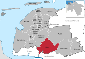
| Location of the municipality of Ihlow in the district of Aurich | ||
  |
||

The municipality of Ihlow is located in the Aurich district in East Frisia ( Lower Saxony ). It has 12,467 inhabitants (as of 2019), a size of around 123 square kilometers, making it the eighth largest municipality in East Frisia and the fourth largest in the Aurich district.
Today's municipality was created as part of the municipal reform on July 1, 1972 from twelve previously independent municipalities. The name of the parish was chosen for historical reasons. It goes back to the Cistercian monastery that was founded in 1228 "ter Yle", zu Ihlow (in the Yl-loh, the yew forest).
In the regional planning of the state of Lower Saxony, the community is run as the basic center . It is characterized by agriculture and tourism with a focus on the Ihler Meer .
The community's cultural heritage includes the Ihlow Monastery , which has been converted into an archaeological park, as well as several medieval churches, five of which have been preserved in Romanesque brick hall churches from the 13th century and the late Gothic Riepster Church from 1554. There are also two Dutch windmills .
geography
Position in space and extent
Ihlow is located in the south of the Aurich district in East Frisia. With an area of around 123 km², it is the eighth largest municipality in East Friesland and the fourth largest in the Aurich district after the district town , Krummhörn and Großefehn . The maximum extension in an approximate east-west direction is around 17.7 kilometers between the border with the community of Großefehn near Ostersander in the east and the Wrantepott residential area on the border with Emden . In north-south direction, the maximum extent is almost 13.2 kilometers between the district of Herrenhütten in the north and the Fehntjer low near Simonswolde . The main town Ihlowerfehn is located about eight kilometers south-southwest of the Aurich core city and about 15 kilometers east-northeast of Emden. The closest major city , Oldenburg , is about 60 kilometers to the south-east.
With a population density of 98 per square kilometer, the municipality is sparsely populated even when compared to inner-East Frisia (East Frisia: around 148 inhabitants per square kilometer; Lower Saxony 168; Federal Republic of Germany around 230). Ihlow is defined as the basic center in the state planning of Lower Saxony . The administrative seat is in Ihlowerfehn .
Geology, hydrology and soils
Geologically, the municipality of Ihlow, like all of East Friesland, is formed superficially by layers of the Pleistocene and Holocene . Pleistocene strata can be found in the geest areas of the municipality, which are in Riepe and Ochtelbur, around Westerende and Simonswolde and especially in a larger contiguous area in the east of the municipality around Westersander and Ostersander. In the last two cases mentioned, the place name already indicates that the soils of the East Frisian Geest were mostly formed from glacial cover sands (sand) and boulder clay . The Holocene layers are the moors lying on the Geest as well as marsh soils , which occur in parts of the municipality in socialized form with other soil types.
In the far west of the municipality and south of the Ems-Jade Canal , Pseudogley can be found underlain by Kleimarsch . To the south of it, in the area of the Riepster Hammrichs , there are fen soils with raw marshland . In a sub-area of the Riepster district, for several decades from 1954 onwards, areas were flooded with silt from dredging in the port of Emden and in the Ems , then drained and - thus improved in soil quality - returned to agricultural use.

In a north-east running narrow strip that extends from Riepe via Ochtelbur and Bangstede to Westerende-Kirchloog, Fahne and Westerende-Holzloog, the floor is a gley - Podsol . To the west of the Ems-Jade Canal , Barstede is also located on this type of soil, surrounded by upland moorland in the southwest, moorland moor in the west and east and Gley with moorland in the north and south. A small area north of the Ems-Jade Canal, which lies in the catchment area of the Great Sea , has a fen with a bend marsh layer . In the vicinity of Westerende-Kirchloog and Westerende-Holzloog, Plaggenesch is located beneath Podsol, and around Neu-Barstede upland moor with a covering culture layer.
In the center of the community is the Ihlower Forest on Pseudogley- Podsol, as is Hüllenerfehn, south of the forest. The surroundings of the forest - Ihlowerfehn in the west, Ludwigsdorf in the north and Ostersander and Westersander in the east - result in a large area that rests on Gley-Podsol. To the north-east of Ludwigsdorf there is a smaller raised bog area, south of Ihlowerfehn the ground consists of gley on a small area.
In the south of the municipality there are Gley-Podsol soils in Simonswolde, north of which there is also Plaggenesch underlayed by Pseudogley brown earth. Between the "chain of villages" Riepe-Ochtelbur-Bangstede in the west, Ihlowerfehn in the east and Simonswolde in the south lies the Blitz-Niederung, named after the body of water of the same name. It consists largely of upland moor in the central part, moor in the southwest and southern part and moor with cover culture in the eastern part.

From the north-east to the south-west, the municipality is traversed by two bodies of water that flow through a valley with fens: the Krumme Tief in the central part of the municipality and the Flumm and Fehntjer Tief further southeast, but initially parallel to the Krumme Tief, which then ends up east from Simonswolde flows into the Fehntjer Tief. Before their confluence, they form a wide lowland zone made up of low earth bogs (see also protected areas ). The area of the Fehntjer Tief, directly on the border with the neighboring municipality of Moormerland to the south, is a low moor with raw marshland and merges into those areas in Riepster Hammrich that also have this type of soil.
The community is criss-crossed by a large number of artificial drainage ditches and canals, including the Ems-Jade Canal , part of the ring canal and the rivers mentioned above. The Fehn canals of the municipality from Ihlower-, Hüllener and Lübbertsfehn flow into the Fehntjer Tief , whereby the latter two are only relatively short branch canals. Almost the entire area is only slightly above sea level . Due to this fact, the area must be continuously drained . The Oldersum Drainage Association is responsible for the majority of the municipality , while a small part in the northwest of the municipality is looked after by the I. Drainage Association Emden, based in Pewsum .
Community structure
The community consists of twelve localities, some of which include several districts. This becomes very clear in the example of Ihlowerhörn, to which three geographically and partly also historically clearly separated localities belong.
| Localities | Residents | associated districts |
|---|---|---|
| Bangstede | 351 | - |
| Barstede | 333 | |
| Ihlowerfehn | 2115 | - |
| Ihlowerhörn | 1062 | Lübbertsfehn , Hüllenerfehn , Westersander |
| Ludwigsdorf | 947 | - |
| Ochtelbur | 899 | - |
| Ostersander | 815 | Weene |
| Riepe | 2160 | - |
| Riepster Hammrich | 147 | - |
| Simonswolde | 1658 | - |
| Westerende-Holzloog | 358 | Herrenhütten, Werringerhörn |
| Westerende-Kirchloog | 1721 | Flag, Fahnstermoor |
| total | 12,566 | - |
The largest village is Riepe with 2160 inhabitants, Ihlowerfehn is only slightly smaller with 2115. It is followed by Westerende-Kirchloog with 1721 and Simonswolde with 1658 inhabitants, the other localities, on the other hand, drop significantly. The smallest village is Riepster Hammrich with 147 inhabitants (as of May 2017). The community center with the town hall is located in Ihlowerfehn, where there are also retail stores. To a lesser extent, this also applies to Westerende-Kirchloog. Riepe is the economic focus of the community not only because of the shopping opportunities there, but above all because of the commercial area close to the motorway.
Land use
| use | Area in ha |
|---|---|
| Building and open space | 846 |
| including living space | 529 |
| of which commercial and industrial space | 62 |
| Operating area | 9 |
| of which mining areas | 5 |
| Recreation area | 51 |
| including green area | 33 |
| traffic area | 598 |
| of which road, path, square | 588 |
| Agricultural area | 9,975 |
| of which moor | 38 |
| Water surface | 442 |
| Forest area | 379 |
| Areas of other use | 13 |
| including cemeteries | 4th |
| of it land | 9 |
| total area | 12,312 |
The total area of the municipality of Ihlow has a high proportion of agriculture (see table of agricultural structure survey ): It is around 80.7 percent and is thus still above the East Frisian average of 75 percent, which in turn is well above the national average of 52 percent. 38 hectares of which are still pure moorland. The nature and landscape protection areas are for the most part recorded under agricultural areas and are partly used extensively. Water bodies, especially the sand water, fen canals and natural depths, but also drainage ditches, cover around 3.58 percent of the municipal area. Ihlow is only sparsely forested with a forest area of a good 3 percent - but is above the East Frisian average of around 2 percent, which means an extremely below-average forest area compared to the Federal Republic of Germany. Trees can be found mainly in the Ihlower Forest and around the Geest villages Westersander and Ostersander in the form of extensive hedge landscapes . Apart from the trees on these hedgerows, the community is very tree-poor, especially in its westernmost part. In earlier centuries the trees were cleared to gain construction and firewood on the one hand, and space for agriculture on the other.
Neighboring communities
Neighboring cities and communities of Ihlows are (clockwise, starting in the west) the independent city of Emden (districts of Uphusen and Petkum ), the community of Südbrookmerland , the city of Aurich (including the districts of Extum , Rahe , Kirchdorf and Schirum ), the community of Großefehn (all Aurich district ) and the Moormerland community in the Leer district . The border to the municipality of Moormerland is in sections the Fehntjer Tief , the border to the municipality of Südbrookmerland on a short section of the Ems-Jade Canal .
climate
Ihlow is in the temperate climate zone . The municipality is mainly in the direct influence of the North Sea . In summer the daytime temperatures are lower, in winter often higher than in the further inland. The climate is generally characterized by the Central European west wind zone.
After the effective climate classification of Köppen is Ihlow is in the classification Cfb .
- Climate zone C : warm-temperate climate
- Climate type Cf : humid-temperate climate
- Climate subtype b : warm summers
The closest weather station is in Aurich.
|
Average monthly temperatures and rainfall for Aurich
Source: German Weather Service
|
||||||||||||||||||||||||||||||||||||||||||||||||||||||||||||||||||||||||||||||||||||||||||
Protected areas

The approximately 350 hectare Ihlower Forest is located in the community and, together with the surrounding area, forms a nature reserve. The Niedermoorsee Sandwater south of Simonswolde is designated as a nature reserve (NSG). The fen landscape on both sides of the Fehntjer low is also a nature reserve. It is the largest in the community. Parts of the NSG are located in the neighboring communities of Moormerland and Großefehn. Around 2800 hectares are also designated as FFH and bird protection areas. Since it was placed under protection, the populations of meadow birds have recovered. In 2010 a total of 278 breeding pairs of lapwing , 100 black- tailed godwit and 60 breeding pairs of curlew were counted. Other species that exist include the brown , blue and stonechat , reed warbler , marsh harrier , spoon and gadfly .
history
The earliest traces of human presence in the municipality are dated to the Mesolithic . Archaeological evidence was found in what is today the districts of Oster- and Westersander.
Only comparatively late, in the 1st half of the 4th millennium BC. BC, peasant groups prevailed against the hunters. There are more extensive finds from the Bronze Age . In Westerende-Kirchloog, for example, a pan and several hatchets and a spout hatchet from the earlier Bronze Age were discovered in the flag . By the way they are manufactured, they indicate that they were manufactured in England or Belgium, which could include extensive trade relationships. In addition, there is no evidence to date that could prove the company's own local production of bronze devices in East Frisia.
Founding phase (before 1000), Aufstrecksiedlung (around 1100)

There was permanent settlement in the municipality in the early Middle Ages . It is assumed that Ostersander and Westersander were founded by settlers from Shirum before the year 1000.
The remainder of today's municipal area remained largely uninhabited. In the early Middle Ages, the area formed a natural border between various districts and the zones of influence of the Bishop of Münster and the Archdiocese of Bremen. This formerly deserted area was made arable through the so-called inner colonization and opened up for the row villages, which can still be seen today in many forms of settlement. There was a larger settlement from 1100, when after devastating storm surges many people pushed from the coast into the interior and developed a new type of settlement here, the Aufstrecksiedlung ( Ostfriesisches Platt : Upstreekrecht ) The row villages Riepe, Ochtelbur and Simonswolde became parcels running in parallel laid out in the moor. Settlers who had settled on the Geestrand near a moor were allowed to drive their parcels parallel to each other into the moor until they encountered natural obstacles or parcels of other settlers who had cultivated the moor from other directions. However, due to the difficulties in cultivation due to the lack of paths, the plots seldom extended lengthways by more than a few 100 meters over 2000 meters. The moor was cultivated by removing the peat and supplying the land with natural fertilizer from adjacent grassland areas of the moorland marshland.
“The size of the arable land at that time was proportional to the extent of the natural grassland. The colonists must have been aware of this aspect at the beginning of the development of the moors, because extension settlements can only be found in East Friesland and also in the Netherlands, where grassland-rich lowlands directly border on high moors. "
The field structure between the villages of Riepe and Ochtelbur on the one hand and Simonswolde to the southeast of it on the other hand shows the removal of the moor by stretching to this day. According to the current state of research, it is assumed that Riepe is the oldest of these villages. Most of the settlers from the Leybucht area have settled here. Several Romanesque churches were built in Ihlow in the 13th century, some of which have been preserved to this day.
Cistercian monastery (1228–1529)
The first founding of a Cistercian monastery in East Friesland failed in Ihlow in the middle of the 12th century. Only the second attempt by the Benedictine double monastery in Meerhausen near Aurich was successful. It had joined the Cistercians in 1219. Their rules provided for a stricter separation of women's and men's monasteries, so that a men's monastery was founded in Ihlow.
The Cistercian monastery Ihlow was one of the most important of the numerous East Frisian monasteries that were founded in the 13th century. It was founded in 1228 by monks from the mother monastery Aduard near Groningen ; the first abbot was installed in 1230. The monastery played an important role because it not only changed the ownership structure, but also brought technical and organizational innovations to the region, increased the drainage of moors and the construction of roads and paths. The abbot took over central functions in dike and sewer construction in western East Frisia and in its maintenance. The monastery also formed the chancellery of the all-Frisian Landfriedensbund and was therefore supra-regionally influential in matters of peacekeeping. This importance also manifested itself in the building itself. The monastery church was the largest between Groningen and Bremen.
As a result of the Reformation , the monastery of Ihlow was destroyed in 1529, the altar and organ came to Aurich. In the dispute over the building and the lands, the count prevailed against the estates.
Under the Cirksena (1464–1744)


On October 1, 1464, Emperor Friedrich III. Ulrich Cirksena to the imperial count status. After the Cirksena was granted the dignity of count, they set about dividing their territory into individual administrative units. An office structure was created . The present area belonged to the Aurich office, the largest within the region, which extended roughly from Marienhafe to Großefehn .
As early as 1550, citizens from Emden and Oldersum in what is now the municipality were concerned with digging peat in the moors for their own fuel supply. The peat was removed via the Fehntjer low and its side arms. At that time, however, the use of the moors was still limited to the peripheral areas.
During the Thirty Years War , East Frisia was captured three times (1622-1624, 1627-1631 and 1637-1651) by foreign troops and used as quarters, even if no major fighting took place. From 1622 to 1624 the Mansfelder occupied East Frisia. The places in the area suffered from the occupation by the troops. The two following occupations also meant burdens through contributions. The occupiers from 1627 to 1631, however, imperial troops under Tilly , “kept male discipline and avoided excesses”, as did the Hessian troops billeted in East Frisia from 1637 to 1651 under Wilhelm V von Hessen-Kassel . Materially, too, the situation was different under the two occupations than under Mansfeld: Although contributions were collected, these were also spent in the region. During the war, the plague broke out in East Frisia , but deaths for the area in question are not documented.
The settlement of the moors, which represent the largest area of the municipality, by fen colonies began in 1637 in Lübbertsfehn, which is one of the oldest fen settlements in East Frisia. The district was originally called Ostersander Vehn, but later named after its founder, the Emden businessman Lübbert Cornelius. Hüllenerfehn followed in 1639. Originally the place was called Westersander Vehn, but later renamed Hüllenerfehn because of the hilly surroundings. Like parts of the neighboring community of Großefehn, parts of Ihlow were created by Emden entrepreneurs to mine peat , which was then brought into the seaport city via specially created fen canals and the Fehntjer Tief . Peat had become scarce due to the turmoil of the Thirty Years' War and an export ban imposed in 1621 by the Netherlands, which until then had been the main supplier of peat to East Frisia.
The Christmas flood in 1717 had devastating consequences for the villages in what is now the municipality. Except for the higher Geest villages , it was completely flooded. A flood mark can still be seen on the church tower in Riepe. 15 people drowned in the village, in Hüllenerfehn there were seven. For comparison: According to a contemporary survey by the preacher Jacobus Isebrandi Harkenroth, 92 people died in the entire Aurich office. The livestock suffered heavy losses. Here, as in other places, the houses were sometimes so badly damaged that parts of the settlement were abandoned and relocated to the Geest in Ostersander. The ravages of the flood were followed by a period of economic decline and poverty.
Prussian rule (1744–1806 / 15)
East Frisia became part of Prussia in 1744 . According to trade statistics produced by Prussian officials, the immediately neighboring towns of Riepe and Ochtelbur in today's municipality were by far the most important economic centers: 29 merchants and craftsmen were counted in Riepe and 22 in Ochtelbur. The number for Riepe was recorded in the Aurich district, the largest in East Friesland, only surpassed by Marienhafe , Großefehn , Timmel and Bagband . In Riepe there were five bakers, shoemakers and carpenters, four bricklayers and tailors, three merchants, two blacksmiths and a cooper. In Ochtelbur there were four merchants, three bakers, bricklayers and carpenters, two tailors and shoemakers and one barber, turner, glazier, dyer and blacksmith each. In contrast, the towns of Bangstede (nine merchants and craftsmen), Barstede (three), Fhne (two), Hüllenerfehn (five), Lübbertsfehn (nine), Ostersander (six), Westerende-Kirchloog (eight) and Westerende-Holzloog (six) fell. clearly.

The hunting lodge in Ihlower Forst, built in 1612, was demolished in 1756, like so many castles and fortresses in East Friesland in that decade. Instead, a new hunter's house was built there. The local hunter was often used in the following decades to decimate the widespread game in the Ihlower Forest, as the farmers in the area complained more often about increasing wild bites.
During the Seven Years' War East Friesland was occupied twice by French troops, with the second occupation by the Marquis de Conflans in 1761/62 causing considerable suffering for the inhabitants. On September 27, 1761, the Aurich crew moved to Emden on the Marquis von Aurich and committed numerous atrocities on the way: An old man in Bangstede and other people are said to have been murdered. In Barstede the priest was taken prisoner and forced to hand over the church utensils; Ochtelbur and Riepe were looted.
With the land reclamation edict (1765), the development of the state was also pushed forward in East Friesland . In the second half of the 18th century, more than 80 new peatland colonies were established in East Frisia . In the Ihlower area Ihlowerfehn (named after the monastery Ihlow) and 1798 Ludwigsdorf, which was named after the president of the Aurich War and Domain Chamber , Ludwig von Vincke , a few years later .
In the years 1798/99 the Treckschuitenfahrtskanal (today's name Treckfahrtstief ) was created between Emden and Aurich , which led through what is now the municipality of Ihlow. With barges , the horses towed were promoted the trek airline mail, cargo and passengers. This also gives the channel its name. "Trecken" is East Frisian Low German and means "to pull". The horses were changed at the Mittelhaus near Riepe. In the years that followed, the operating company suffered from the constantly changing rulers: In 1806, East Frisia became part of the Kingdom of Holland , in 1810 to France and in 1815 finally to the Kingdom of Hanover . Even later, it was unable to establish itself in the long term, as the plan to run the canal through the entire East Frisian peninsula failed, not least due to insufficient funding. Only in the years 1880 to 1888 was the plan from the beginning of that century implemented to lengthen the canal. It was expanded to Wilhelmshaven and henceforth called the Ems-Jade Canal . That came too late for the Treckfahrtsgesellschaft: the construction of highways and railway lines in East Frisia in the 1860s meant the end of society. However, shipping continued to exist. Among other things, the neighbors used the canal to transport agricultural products to Aurich and Emden, the residents of Barstede, for example, to transport their butter.
Hanoverian and Imperial Era (1815–1918)
While East Friesland belonged to the Kingdom of Hanover, the present area belonged to the Aurich Office. The majority of Ihlow's formed the Lower Bailiwick of Riepe within the Bailiwick of Aurich. The parishes of Riepe, Ochtelbur, Barstede, Bangstede, Fahne and Westerende, but also Wiegboldsbur, Bedekaspel and Forlitz-Blaukirchen (today Südbrookmerland ) belonged to it. The east of the present area with Ostersander, Westersander, Ihlowerfehn, Lübbertsfehn, Hüllenerfehn, Ludwigsdorf and the monastery district belonged to the Untervogtei Weene within the Bailiwick of Holtrop . The south around Simonswolde, on the other hand, did not belong to the Aurich office at all at that time, but to the Emder and was assigned to the glory of Oldersum there. The number of inhabitants in the villages differed very significantly: While 464 inhabitants were given for Westerende in the early 1820s, there were 242 in Bangstede, 175 in Barstede, 123 in Riepster Hammrich, 324 in Ochtelbur, 200 in Ostersander, 220 in Westersander , 141 in Hüllenerfehn, 257 in Lübbertsfehn, 98 in Ludwigsdorf, 89 in Ihlowerhörn and over 600 in Riepe.Ihlowerfehn had 201 inhabitants at that time, but hardly grew in the first 20 years of the 19th century because the moor along the Ihlowerfehn Canal was already excavated and an extension of the Fehn Canal would have required the construction of a lock - but the colonists shied away from the associated costs. The cut peat therefore first had to be carted by wagon to the pier in Ihlowerfehn, which made the peat more expensive compared to that from other feudal settlements in East Frisia.
During the Hanoverian period, two roads led through the community, leading from Aurich to Emden. One of the two over Westerende and Riepe was almost regularly flooded in winter, whereas the higher path built next to the trek canal remained dry in winter. From an agricultural point of view, keeping goose on the water-rich communal pastures was of great importance in the lowlands around Riepe, Ochtelbur and Simonswolde. In particular, the plains around Riepe were characterized by a large number of smaller inland seas well into the 19th century. The extensive pastures, which stretched from Westerende in the north to Simonswolde in the south and were used as pastures not only by the residents, but also by the citizens of Aurich, were often under water. However, drainage was still a major problem at the beginning of the 19th century.

In the first half of the 19th century, the importance of shipping for the Fehn residents in Ihlowerfehn steadily increased. In contrast to the residents of Großefehn , Warsingsfehn or Rhauderfehn , however, inland shipping remained in Ihlowerfehn on the East Frisian canal network, which essentially consisted of transporting the peat to the cities of Emden and Leer and the surrounding marshland areas. At the same time, shipyards gained in importance. While in Ihlowerfehn there were just 19 inland vessels in 1816, the number had risen to 44 by 1848 and peaked at 50 in 1882. After that, however, a noticeable decline sets in, in 1900 only 30 ships were registered. One cause was the increasing coal production, which gradually replaced peat as fuel. In addition, the barges suffered from increasing competition from the railways.
However, shipping continued to be of great importance as a labor market. Previously self-employed boatmen were hired by shipowners in other places, namely in Emden and Leer, but also beyond. The Emden herring fishery, for example, as well as shipping companies operating overseas were important. Until the 1960s, the shipping companies recruited many of their captains, helmsmen and sailors from the feudal settlements, where a professional tradition as seafarers had emerged over the decades. Shipbuilding also remained important in Ihlowerfehn on a smaller scale, even though the shipyard of master shipbuilder Cassen Cassens followed the trend towards larger ships and relocated his company to the seaport of Emden (1875).
For the two other feudal settlements Lübbertsfehn and Hüllenerfehn, however, a different picture emerged. In 1816 the boatmen from Lübbertsfehn had twelve ships, eight of which were peat ships for inland traffic and four ocean-going ships for coastal traffic. Similar in Hüllenerfehn: There were eleven here, six of them for small sea traffic. As early as 1862 there were only three ships left in the two Fehns combined. In the course of the 19th century, the Lübberts and Hüllenerfehntjer increasingly looked for their livelihood in agriculture. This fits in with the fact that the average size of the colonists in Hüllenerfehn with 6.5 hectares and in Lübbertsfehn with 5.5 hectares was larger than in all other East Frisian fen colonies.

The expansion of the infrastructure was promoted in the German Empire. So around 1876 the paved road from Oldersum via Riepe, Ochtelbur and Westerende-Kirchloog to Aurich (today's L 1) was built. In 1911, the somewhat remote places Lübbertsfehn and Hüllenerfehn were connected to the road network by a brick road.
The Ems-Jade Canal , which connects Emden and Wilhelmshaven, was laid through the municipality between 1880 and 1888 . The trek low was included in this, but the creation of protective dikes was necessary. The construction of the Ems-Jade Canal meant not only wages and salaries for the workers who excavated it for eight years. He also improved the agricultural conditions in the neighboring communities, because fertilizer could be more easily brought in in larger quantities.
Weimar Republic
The entire district of Aurich (= Altkreis Aurich, i.e. today's municipalities of Aurich , Ihlow, Südbrookmerland , Großefehn and Wiesmoor ) was one of the strongholds of the ethnic and later National Socialist parties in the north-west of what is now Lower Saxony. Ihlow was no exception.
As in the entire north-west of Lower Saxony, the rural people's movement was given a boost in the Weimar Republic after a bad harvest occurred in 1927 and the farmers were increasingly in dire straits. However, by focusing on quantities rather than quality, the problems were partly homemade. As in other parts of the country, the black flag, symbol of Florian Geyer's Black Band in the Peasants' War , fluttered as a sign of protest. On January 5, 1928, there was a large demonstration by farmers from the region in Aurich, in which 4,000 people took part. The National Socialists, with their blood-and-soil ideology, saw themselves as guardians of the needs of the farmers and found appropriate support in many communities.
In the Reichstag elections in 1928 , the NSDAP in the Aurich district achieved results that were far above average when compared with the Reich. While it received 2.6 percent of the vote across Germany, it was 13.4 percent in the Aurich district. The strongholds of the party included Bangstede and Westersander, where the NSDAP won the most votes. This she won equally from the left-liberal DDP , from the right-liberal DVP and the right-wing extremist DNVP .
On October 16, 1928, a local NSDAP group was founded in Aurich, and members from the surrounding area also joined. In the period that followed, a Nazi speaker spoke in Riepe, among others. The district elections of 1929 caused the National Socialists to lose votes compared to the Reichstag election the year before, but this was not least due to the fact that more free lists led by local personalities were successful at the municipal level. Most of these were assigned to the conservative spectrum. In the district election, the building supervisor Gerd Hinrichs from Westerende-Kirchloog moved to the district assembly for the SPD, the Simonswoldmer farmer Aisse Stromann for the NSDAP and the Hüllenerfehntjer community leader Albert Albers and the farmer Gerhard Damm from Riepsterhammrich. After the outbreak of the global economic crisis in 1929 and before the collapse of the coalition government in Berlin in March 1930, the NSDAP also intensified its propaganda in the Aurich district. In January there were several rallies in the district, one of them in the Fahnster Krug in Fahne.
At a NSDAP meeting in Aurich, which was linked directly to a rural people event in February, the two groups were already working towards one another. Finally, the Aurich (and East Frisian) SPD also recognized the dangers inherent in the growing National Socialism in the region. In particular , Hermann Tempel , a member of the Reichstag and editor of the social democratic weekly Volksbote , spoke to supporters in the region more and more. Nevertheless, the National Socialists managed to more than double their voting result in the 1930 Reichstag election : from 13.4 to 30.6 percent. The DNVP received a further 23.8 percent, so that the extreme right already achieved an absolute majority in that election. In the period that followed, the NSDAP also expanded its party structure by founding new local groups. Up until then there had only been a local group in Aurich, the first outside the city included the local group Weene, which included Schirum , Ostersander and Westersander . The local group, founded in 1930, was headed by Walter Drange.
In the following three years, the NSDAP became by far the decisive force in the district. It not only won the elections - as in many other places - from the liberal parties. The National Socialists also ousted the DNVP, especially in the rural, small-scale surrounding of Aurich. In March 1933, the NSDAP received 71.7 percent of the votes in the district (excluding the city of Aurich), the DNVP only 6.5 percent. Individual locations stood out in particular: In Bangstede, the NSDAP received 95.9 percent of the vote. The historian Herbert Reyer spoke of an "extremely (more) failed rejection of Weimar democracy in the Aurich region, which in 1932 had finally proven and stabilized as one of the very large National Socialist strongholds in the Reich."
National Socialism
The farmers in the municipality were in the Reich into line . The passing of the Reichserbhofgesetz met with protests from many farmers, as they felt that their economic freedom of choice was limited. In the moor colonies such as Ludwigsdorf or Neu-Barstede there was also the fact that the agricultural properties were often too small to represent a full-time farmer. The ban on selling hereditary farms therefore hit those businesses with the lower size limit of a hereditary farm of 7.5 hectares in particular. Although there were many judicial judgments in favor of the plaintiff smallholders, the proportion of hereditary farms in the region remained above the national average. One son of the community showed himself to be particularly committed to enforcing the hereditary farm rules: Theodor Trauernicht from Ostersander, who was a district farmer.
In 1933 there were a total of 30 local groups of the NSDAP in the Aurich district. In particular, the younger among the new members were asked to join the SA at the same time as they joined the party , which happened almost without exception. At the beginning of the war in 1939 there were two SA storms in Westerende and Riepe in what is now the municipality .
During the Second World War there were a number of foreign and forced labor camps in the municipality. A total of three prisoners escaped from the camps in Ochtelbur and Bangstede on the night of July 8th to 9th, 1942, and their further fate remained unknown.
The war did not end in the present area until the beginning of May 1945. On May 3, Canadian troops stood east of Westersander. Further to the west, the Großefehn Canal and the Fehntjer Tief still formed the front course. In order to save the city of Aurich from destruction in view of the military situation, two parliamentarians, student Friedrich van Senden and local health insurance manager Heinrich Alberts, drove via Ihlowerfehn and Lübbertsfehn to a quarter of the Canadians in Westgroßefehn to see the city being surrendered without a fight to negotiate. After confirmation by the military leadership in Aurich, the armistice came into force on May 5th, and the present area was occupied by the Allies.
After 1945
After the war, refugees from the eastern areas of the German Reich were taken in in what is now the municipality, but with an uneven distribution: "The bog colonies took in the fewest refugees," says a study by Bernhard Parisius . The refugees came to a district which at that time was already characterized by a lack of jobs. In addition, there was a lack of adequate and healthy living space. In the activity report of the Aurich district administration for the election period 1948–1952 it says:
“Sufficient work and living space could not be created for all of these people, especially since the cities of Emden and Wilhelmshaven had been broken up and some of their residents had also been evacuated to the Aurich district. The military government instructed the displaced persons to attend to this unnatural increase in the population, which was in complete contradiction to the capabilities of the district. That meant a catastrophe for both parties: for the Aurich district and for the displaced! The recurring unemployment affects the displaced the most. Although they only make up 15% of the population, they contribute around 30% to unemployment. The housing shortage has just as severe an impact. [...] So the displaced were mostly assigned the poor side rooms, summer kitchens, up-chambers, milk rooms and bakeries, which are as unhealthy as they are inhumane, like the Nissen huts and barracks. The housing misery of the displaced in the Aurich district is confirmed by the State Statistical Office by the statement that "the district of Aurich has the highest density of housing in Lower Saxony with the smallest average apartment size". "
1954 began to flood the agriculturally used area in Riepster Hammrich with the silt that arose during dredging in the Ems, the fairway of the Emden harbor . Between 1954 and 1994, more than 100 million cubic meters of silt were washed onto the fields, which then fell dry. The floors have been significantly upgraded.
The municipality was created on July 1, 1972 as part of the municipal reform through the merger of the twelve independent municipalities Bangstede, Barstede, Ihlowerfehn, Ihlowerhörn, Ludwigsdorf, Ochtelbur, Ostersander, Riepe, Riepsterhammrich, Simonswolde, Westerende-Holzloog and Westerende-Kirchloog.
From 1973 the East Frisian landscape began with systematic excavations on the site of the former Cistercian monastery, in which farm buildings were initially recorded. In 1977 the foundations of the monastery church, parts of the floor and several graves were found. In order to make the dimensions of the church more tangible, the floor plan was reconstructed with bricks in 1986. Since 2000 there have been plans to create an archaeological park on the site of the former Cistercian abbey. The construction work on the 3 million euro project lasted from 2005 to 2009. At the beginning of 2007 excavations took place again on the site. The foundations of the monastery church were exposed and the pillars reconstructed. The church, reconstructed as a steel sculpture in abstract form, has since been the focus of the "Archaeological Park Klosterstätte Ihlow". This project is part of the cross-border project Zisterzienserstraße , which - with the support of the EU - aims to make pilgrimage routes of the Cistercians from Belgium to Estonia tangible as a European heritage.
The municipality of Ihlow has been severely affected by demographic change. In 2010 there were 162 ten-year-olds in the parish, but only 72 newborns. In Ihlow there is a very pronounced educational migration, especially of people at the beginning of their studies or career start phase.
politics

The municipality of Ihlow is traditionally a stronghold of the SPD during elections - like East Friesland in its entirety. Despite the loss of the absolute majority in the municipal council in the 2011 local elections, it remains by far the strongest party and achieves the best result in state and federal elections. The mayor is also a social democrat.
As early as the 1949 federal election it became apparent that the Social Democrats enjoyed strong support, especially in the more populous western villages such as Riepe, Simonswolde, Ochtelbur and Westerende-Kirchloog. They won there as well as in Ludwigsdorf, Bangstede, Barstede and Westerende-Holzloog. In the rural Riepster Hammrich the German party won , but in Ihlowerfehn, Ihlowerhörn and Ostersander, which were also rural, the Christian Democrats won. Despite a few exceptions - the CDU was very successful in the 1969 Bundestag election in East Friesland and won a majority in six of the then twelve communities in Ihlow - it remained so in the decades that followed. The "Willy Brandt election" in 1972 , which generally brought record values for the Social Democrats in East Frisia, also saw the breakthrough in previous CDU strongholds such as Ostersander and Ihlowerhörn.
The planned motorway feeder for Aurich (B 210 new), which is to lead through the municipality, is highly controversial in the municipality of Ihlow. In the election to the district administrator of the Aurich district in September 2011, the candidate Antje Groenewold, opponent of expansion, won more votes in the municipality of Ihlow than the candidate Harm-Uwe Weber, who was supported by the SPD and CDU supporters of expansion.
Municipal council
The Council of the Municipality Ihlow consists of 30 women and Council councilors. In addition, the mayor , Johann Börgmann (SPD), is a voting member . The current term of office began on November 1, 2016 and ends on October 31, 2021. The last local election on September 11, 2016 (voter turnout: 55.2 percent) resulted in the following result:
| Political party | Voting share | Seats | change |
|---|---|---|---|
| SPD | 49.47% | 15th | ± 0 |
| Independent constituency Ihlow | 21.04% | 6th | ± 0 |
| CDU | 17.59% | 5 | ± 0 |
| Alliance 90 / The Greens | 9.94% | 3 | ± 0 |
| FDP | 1.95% | 1 | + 1 |
| The left | - | - | - 1 |
The SPD parliamentary group has 15 out of 30 votes in the council and, in conjunction with the SPD mayor, receives just under an absolute majority.
In addition, there are elected local councils in ten localities that deal with purely local issues. In Bangstede and Riepsterhammrich, this task is taken over by the respective town councilors.
mayor
In May 2014, Johann Börgmann was confirmed in office with 80.8 percent of the votes.
Representatives in the Landtag and Bundestag
A member of the constituency 86 Aurich (Aurich, Südbrookmerland, Ihlow, Großefehn, Brookmerland, Großheide) is represented in the Lower Saxony state parliament (legislative period until 2022) . The direct mandate won in the 2017 election of the Aurich social democrat Wiard Siebels . He stood for the first time in the state elections in 2008. No other politician from the constituency entered the state parliament via the parties' list.
In federal elections, Ihlow belongs to constituency 24 Aurich - Emden . This includes the city of Emden and the district of Aurich. In the 2017 federal election , the social democrat Johann Saathoff was directly elected. No party candidate from the constituency entered the Bundestag via the parties' list.
Municipal coat of arms, flag and official seal
|
|
Blazon : “Split in a wave cut; in front in gold twelve green clovers (2: 3: 2: 3: 2 placed), behind growing in red a golden abbot's staff with a curvature turned to the left. " |
| Justification of the coat of arms: The clovers symbolize the twelve districts, the abbot stands for the former Cistercian monastery. The wavy line in the middle symbolizes the waters of the typical fen landscape. |
The colors of the church are red (above) and yellow (below). The official seal contains the coat of arms and the inscription Gemeinde Ihlow, Landkreis Aurich .
Municipal finance
In 2012, for the first time since 1995, the municipality of Ihlow generated a surplus in the municipal budget. In previous years deficits had always formed - also, but not only due to massive investments. The 2012 surplus was 338,000 euros.
Partner municipality
Ihlow has had a partnership with the Baranów Municipality in Poland since 1997 . It was officially sealed on July 14, 1997. However, contacts with Baranów have existed since 1993. Since then, several mutual visits by delegations have taken place. The partnership between the two municipalities was one of the triggers for the partnership between the Aurich District and the Powiat Kępiński , to which Baranów belongs.
religion

In the Middle Ages, the border between the dioceses of Bremen and Münster ran through what is now the municipality . The northeast with Bangstede, Barstede, Weene and Westerende belonged to Bremen from an ecclesiastical point of view, the southwest with Riepe, Ochtelbur and Simonswolde to Münster. Ihlow Monastery, which was founded in 1228, but was abolished in 1529 as a result of the Reformation, was influential. The parishes joined the Protestant creed and, with the exception of the Reformed Simonswolde, all became Lutheran . In 1899 the parish of Ihlow was founded for the new fen colony, which has had its own church building since 1902. The Lutheran congregations are now part of the church district Aurich, of around 75,000 church members the second largest church district of Hanover Lutheran Church is.
Free churches have no independent parishes in the area of the integrated parish. In the second half of the 19th century, the Methodists built a small chapel in Ihlowerfehn, which was later abandoned when the work concentrated on Aurich and Neuschoo .
The Ihlower Catholics are members of the Aurich parish with its St. Ludgerus Church . For Muslims , the Eyup Sultan Mosque in Emden is the closest mosque.
Economy and Infrastructure

Due to the location between the cities of Aurich and Emden, the number of out- commuters is high. Many Ihlowers are employed by companies and authorities in Aurich, as well as companies in Emden, such as the Volkswagen plant there . In 2006 there were 3,684 employees at the place of residence subject to social security contributions in the municipality. However, there were only 1,460 jobs subject to social insurance in Ihlow. The community recorded 851 in-commuters from other communities, but 3,075 out-commuters from Ihlow who earned their living across the community.
Measured by the number of employees subject to social security contributions at the place of work, trade in Ihlow plays the leading role with a share of 30.1 percent. Another 23.6 percent are in the (general) service sector, 4.4 percent in transport and communications and 0.7 percent in the hospitality industry. Overall, the service sector has a share of 58.8 percent. The manufacturing industry has a share of 20 percent, a further 17.4 percent work in the construction industry. The manufacturing and construction industries together make up 37.4 percent of the workforce at the Ihlow site. In the primary sector (here exclusively agriculture), 3.5 percent are employed subject to social security contributions, whereby the actual number of people working in agriculture (as well as in the hospitality industry) is significantly higher, as the (usually self-employed) farmers and their family members help out in the Overview of employees subject to social security contributions are not included.
Separate labor market data for the municipality of Ihlow are not collected. Together with the cities of Aurich and Wiesmoor as well as the communities of Großefehn and Südbrookmerland, Ihlow forms the Aurich branch within the Emden-Leer district of the employment agency . In the Aurich division, the unemployment rate in December 2015 was 6.5 percent and thus 1.1 percentage points above the average in Lower Saxony.
Established businesses
Manufacturing companies can be found primarily in the municipality's largest industrial park, which is in the immediate vicinity of the Riepe junction on the A31. Several food manufacturers, a printing company, a manufacturer of boilers for hot-dip galvanizing and a plastics technology company are located here. A major car recycling company is active in the business park in Bangstede. After companies settled in the Riepe industrial estate, Ihlow set a record for trade tax income of EUR 2.79 million in 2010 . Plans for an intermunicipal industrial park near Simonswolde near the autobahn, which was to be operated with the neighboring communities of Südbrookmerland and Großefehn, had to be abandoned in 2010: the soil there was polluted, and excavating the soil would have been too expensive.
Agriculture
Agriculture has always been the determining economic factor in Ihlow and still contributes to value creation today . However, due to mechanization and increased productivity, agriculture only employs a declining number of people. From 1991 to 2007 the number of farms decreased by almost half, while the area of existing farms increased. This was accompanied by an increase in the area of the existing operations. According to the moor and geest situation and the corresponding lower soil quality, grassland management, i.e. dairy farming, is predominant . The district of Aurich is the eleventh largest milk producer district in Germany, to which the community of Ihlow makes a major contribution due to the high proportion of agricultural land and the above-average size of the community. Dairy farmers have been suffering from very low milk prices for several years. The number of dairy farmers decreased by a little more than 60 percent between 1991 and 2007, while the number of dairy cows fell by more than 13 percent. However, this was not associated with a reduction in the amount of milk, as the milk yield per cow increased significantly. Goat and pig farming is of little importance compared to cattle farming, but poultry farming is increasing.
Only in Riepster Hammrich, where from the 1950s a large area was flooded with silt from dredging in the Ems, was the soil quality significantly improved. Agriculture is given preference there. Mainly corn and wheat are grown . The maize is mainly grown for the production of silage . The sharp increase in the number of biogas plants led to an expansion of the cultivation areas for maize, which in East Frisia grew by 60 percent between 2005 and 2010. This was accompanied by an increase in the price of agricultural land for arable land and grassland by 31 and 40 percent.

After the Second World War, land consolidations took place in the community on a large scale. As the last measure so far, the process in the localities of Ihlowerhörn, Hüllenerfehn, Lübbertsfehn and Westersander was completed in 2009 after 21 years.
Farmers earn extra income by setting up wind turbines or by making appropriate areas available. Due to the frequent and strong winds and not least because of the thin settlement, Ihlow is suitable for the use of wind energy . There is a larger wind farm in the municipality between Riepe / Ochtelbur and Simonswolde. In addition, farmers occasionally offer farm holidays .
tourism
Tourism is now also of some importance. In the main town of Ihlowerfehn in particular, a corresponding infrastructure has been built since the 1990s. In the early 1990s, the Ihler Meer leisure facility was built with the help of funding programs . Since then, the number of overnight stays and guests has risen steadily: In 1991, 1350 guests with 7350 overnight stays were counted, in 2001 it was already 3307 guests and 31,750 overnight stays. The number of guests from 2011 and 2012 is not available. The Chamber of Commerce and Industry for East Friesland and Papenburg gives the number of overnight stays for 2011 at around 47,000 and for 2012 at 48,175. Short breaks and group travelers make up the majority of the visitors. 35 landlords offer accommodation in pensions, holiday apartments and houses.
traffic
The Riepe junction of the A 31 is located in the municipality . Landesstraße 1 leads from there via Riepe to Aurich. In the east, the municipality touches the B 72 between Aurich and the Filsum junction on the A 28 . Ihlow does not have a siding. The nearest train station is in Emden , where there is a bus connection that runs a few times a day. Buses go to the district town of Aurich much more frequently.
The expansion plans for the B 210 also affect the Ihlower municipality. The Ihlower local council spoke out against the project in July 2011 with a large majority.
The Ems-Jade Canal crosses the community. It is true that this is primarily important for recreational shipping. In the village of Bangstede, however, there is also an industrial park with an attached quay on the canal. Barges can moor there to deliver to a flour mill. The Voss shipyard is located at the harbor in Westerende-Kirchloog .
Public facilities
There are no larger public institutions in the municipality, apart from the municipal administration. There is a police station in Ihlowerfehn, but it is not manned around the clock. There are around 230 firefighters on duty in the five volunteer fire brigades in Riepe, Simonswolde, Ochtelbur, Weene and Ihlowerfehn.
education
There are four primary schools in Ihlow: in Westerende-Kirchloog, Weene, Riepe and Simonswolde. The primary school in Weene, located near the border with the city of Aurich, is also attended by students from the Aurich district of Schirum . The Hermann-Tempel comprehensive school is located in the main town of Ihlowerfehn . It is a cooperative comprehensive school that offers lessons up to and including lower secondary level. The closest grammar school is the Ulricianum grammar school in Aurich, where there is also an integrated comprehensive school . The closest vocational schools are in Aurich and Emden. The nearest university of applied sciences is also located in Emden , the nearest university is the Carl von Ossietzky University of Oldenburg in Oldenburg.
The Aurich district group of rural adult education is based in Ihlowerfehn. The district of Aurich maintains the Fehntjer Tief nature reserve in the Lübbertsfehn district. It is located in a former Gulfhaus - a farmhouse typical of East Friesland - in the immediate vicinity of the Fehntjer Tief nature reserve and serves as an extracurricular learning location for students from the entire district and as an event room. The Aurich district adult education center has a branch in Ihlow.
media
Ihlow is in the circulation area of three daily newspapers. The long-established local newspaper of the Auricherland is the Ostfriesische Nachrichten . Then there is the Ostfriesen-Zeitung , which is the only one of the East Frisian daily newspapers to appear across the region. Both appear in the publishing house Zeitungsgruppe Ostfriesland . In the area bordering Emden, the Emder newspaper is also occasionally read. An advertising paper that appears free of charge is the Heimatblatt / Sonntagsblatt, which is published twice a week by the Emder Zeitung publishing house, on Wednesdays as the Heimatblatt and on Sundays as the Sunday paper. In all cases, the editorial support is provided by Aurich. From the community also reports of citizens broadcast transmitter Radio Ostfriesland .
Culture and sights
The Archaeological Park Klosterstätte Ihlow

The most important attraction of the community is the archaeological park in and around the former Ihlow monastery, completed in 2009 . The most striking building in the park is the imagination of the choir and the chancel of the former monastery church, which rises to a height of 45 meters well over the tops of the surrounding trees and is intended to illustrate the dimensions of the temple. At the level of the exposed foundation walls, a room was set up for the search for traces, in which an exhibition of excavation finds can be seen. There is also a new altar here. A newly laid out monastery garden in the area of the former enclosure shows plants and herbs as well as their effect and importance in the Middle Ages in four themed areas .
Churches

Located in the municipality in several districts of medieval churches, of which five brick churches have up to the present time received, five of hall churches from the 13th century, Romanesque or transition style , and the late-Gothic church in Riepe . Some of the furnishings are of supraregional importance in terms of art history.
13th Century
- Nikolaikirche in Weene (late 13th century): three carved wooden sculptures in Gothic style, a crucifix from the 13th century, a Vesper picture (end of the 14th century) and an Anna selbdritt (around 1500).
- Bangsteder Church (end of the 13th century): reliquary box from the second half of the 13th century, a Madonna (between 1251 and 1350), a wooden sculpture of St. George from the 2nd half of the 14th century and a bishop's figure from between 1460 and 1470. These are exhibited in the East Frisian State Museum in Emden. The largely preserved organ was built by Johann Gottfried Rohlfs in 1795.
- Ochtelburer Church (second half of the 13th century) due to dilapidation, a large part of the walls was rebuilt in 1742 and 1861. The old baptismal font, which rests on four lions and is decorated with dew ribbons and tendril friezes , has also been preserved here. The pulpit cage dates from 1678 and is attributed to the workshop of Hinrich Cröpelin .
- Simonswoldmer Church (end of the 13th century) has received its late Gothic character from the 15th century due to the polygonal choir and the pointed arched windows on the south side. A grave slab made of red sandstone dates back to the middle of the 12th century. The pulpit, created in 1598, is one of the oldest examples of sacred Renaissance art in East Frisia. The St. Martin Church with a semicircular apse in Westerende-Kirchloog was also built at the end of the 13th century. The Romanesque font has been preserved from this period. In 1793 Johann Friedrich Wenthin built the organ, which was extended by Johann Diepenbrock in 1885 , but is still largely original.
- St. Martin in Westerende-Kirchloog , probably second half of the 13th century, Romanesque with baroque interior.
16th Century
- In the late Gothic Riepster Church from 1554, two trapezoidal tombstones from the unpreserved cruciform church were taken from the mid-12th century. The Romanesque baptismal font made of Bentheim sandstone also comes from the previous building . Most of the wooden furnishings such as the altar, pulpit, west gallery and church stalls date back to the 17th century. Because of its shape, the free-standing bell tower with its baroque dome is commonly known as the "Riepster Teebüs" (tea caddy).
20th century
- The Barsteder Church was built in 1953 on the site of the medieval village church that was in danger of collapsing and contains valuable furnishings from the previous building. The baptismal font made of Bentheim sandstone (around 1200) is one of the oldest in East Frisia.
- The Ihlower Church has no historical predecessor. It was built in 1902 for the new fen colony Ihlowerfehn after the parish was founded in 1899. It is built in the style of historicism with blind niches , stepped buttresses and a round arched frieze . The built-in west tower is decorated with a rosette as a cover. The uniformly wood-like interior design gives the room its unity.
Other sights


The Tjalk coat of arms from Ihlow was built in Groningen in the early 20th century and was one of the first to have an iron hull . The ship came into the possession of the municipality around 1980 and has been restored by an association of the same name. Your berth is at the Fahnster Bridge on the Ems-Jade Canal . Trips to the East Frisian islands and the coastal towns are offered by the association. The ship regularly takes part in larger events such as the Emden Harbor Festival or the Sail in Bremerhaven .
In the municipality there are old Gulf farms in all localities and in the districts . A Gulfhof in Lübbertsfehn from 1843 was purchased by the Aurich district in 1989 and has served as the district's nature conservation station ever since. During the opening times of the nature conservation station, the architecture of this farmhouse typical of East Frisia can therefore be viewed from the outside as well as from the inside.
The Schlickmuseum is located in the village of Riepe . It documents the overview of the Riepster Hammrichs from 1954 to 1994. It is housed on the first floor of a bank building. However, it only opens on request.
In Riepe there are two water mills that were used for drainage until the Hammrich was silted up . The flutter mill is a faithful replica of an older mill, the more than 300 year old coke mill was renovated in 1984. Dutch windmills are located in Ihlowerfehn and Simonswolde.
The Galerieholländer Mühle Berta was built in 1870 and is located south of Ihlowerfehn. It was last extensively repaired in 1989. Cap and wings will be restored from the end of 2019 to spring 2020.
Regular events
The Ihlower Monastery Days take place annually on the monastery grounds, during which there are guided tours of the area. The event, set up as a garden festival, also attracts exhibitors, artists and craftsmen who present their work. In the moor house in Simonswolde, concerts are given in the series "Weltklassik am Klavier", which began in Rysum and is now also performed in other communities.
language
In Ihlow, East Frisian Platt is spoken in addition to High German . In the community, attempts are being made to promote the use of the Low German language, among other things, through bilingual kindergartens. There is one in Simonswolde. There are also Low German church services .
Personalities
The better-known people from Ihlow include three politicians:
- Theodor Trauernicht (born June 1, 1896 in Ostersander; † July 21, 1970 ibid.) Was a member of the Lower Saxony State Parliament ( SRP ) and previously, during the Nazi era, district farmer leader of the Aurich district.
- Günter Lüttge (born July 8, 1938 in Hanover; † September 7, 2000 in Ihlow), was the first mayor of the newly founded municipality of Ihlow from 1972. From 1978 to 1989 the social democrat was a member of the Lower Saxony state parliament and from 1989 until his death in 2000 a member of the European Parliament .
- The former SPD member of the Bundestag Jann-Peter Janssen , who comes from the north , lives in the municipality of Ihlow , as does Markus Paschke , who has represented the SPD in the Unterems constituency since 2013 . Paschke lives in Riepe.
literature
- Bernhard Buttjer; Martin Stromann: Where the monks once lived: The Ihlow monastery, a forest and twelve villages . Verlag SKN, Norden (Ostfriesland) 2009, ISBN 3-939870-22-6 .
Web links
- Literature about Ihlow in the catalog of the German National Library
- Link catalog on the subject of Ihlow (East Friesland) at curlie.org (formerly DMOZ )
- Ihlow parish
Individual evidence
- ↑ State Office for Statistics Lower Saxony, LSN-Online regional database, Table 12411: Update of the population, as of December 31, 2019 ( help ).
- ↑ http://www.luftlinie.org : Ihlowerfehn – Aurich , accessed on May 19, 2018.
- ^ Heinz Voigt, Günter Roeschmann: The soils of East Friesland. In: Karl-Heinz Sindowski, Heinz Voigt, Günter Roeschmann, Peter Schmid, Waldemar Reinhardt, Harm Wiemann: Geology, Soils and Settlement of East Friesland (= East Friesland in the protection of the dike. Vol. 1). Verlag Deichacht Krummhörn, Pewsum 1969, pp. 51–106, here p. 96 with cartographic supplement.
- ^ Eberhard Rack: Small regional studies of Ostfriesland. Isensee Verlag, Oldenburg 1998, ISBN 3-89598-534-1 , p. 24.
- ↑ For the following explanations cf. the soil overview map 1: 50,000 of the Lower Saxony State Office for Mining, Energy and Geology , www.nibis.lbeg.de: map server , accessed on May 19, 2018.
- ↑ http://www.entwaesserungsverband-oldersum.de : Map of the association area , accessed on May 19, 2018 (PDF).
- ↑ www.ihlow.de: villages , accessed on May 19, 2018th
- ↑ Source: State Office for Statistics and Communication Technology Lower Saxony , accessed on May 19, 2018.
- ^ Eberhard Rack: Small regional studies of Ostfriesland. Isensee Verlag, Oldenburg 1998, ISBN 3-89598-534-1 , p. 115.
- ↑ Heinrich level, Uwe Mosig: Bird protection at the Fehntjer low - successful securing of wet grassland. In: Annual report 2010 of the Lower Saxony State Office for Water Management, Coastal Protection and Nature Conservation , available online at www.nlwkn.niedersachsen.de , accessed on May 19, 2018.
- ^ Bernhard Buttjer; Martin Stromann: Where the monks once lived: The Ihlow monastery, a forest and twelve villages . Verlag SKN, Norden (Ostfriesland) 2009, ISBN 3-939870-22-6 , p. 122. Buttjer / Stromann generally speak of the “Stone Age”. Wolfgang Schwarz becomes more precise: The prehistory in East Friesland. Leer 1995, ISBN 3-7963-0323-4 , p. 25, cartographic representation. The area of Oster- and Westersander is designated as a site of the Mesolithic.
- ^ Günther Gerhard Meyer: Did Ötzi trade bronze axes with the Ihlowern? In: Sunday paper of September 27, 2009 (PDF; 640 kB).
- ↑ Wolfgang Schwarz: The prehistory in East Friesland. Leer 1995, ISBN 3-7963-0323-4 , p. 165.
- ^ Bernhard Buttjer; Martin Stromann: Where the monks once lived: The Ihlow monastery, a forest and twelve villages . Verlag SKN, Norden (Ostfriesland) 2009, ISBN 3-939870-22-6 , p. 127.
- ^ Eckhard Wassermann: Settlement history of the moors. In: Karl-Ernst Behre, Hajo van Lengen (Ed.): Ostfriesland. History and shape of a cultural landscape. Verlag Ostfriesische Landschaft, Aurich 1995, ISBN 3-925365-85-0 , pp. 93–112, here p. 98.
- ↑ http://www.ihlow.de : Riepe: Historisches , accessed on May 19, 2018.
- ↑ The founding date 1228 has meanwhile been supported by dendrochronological investigations, see http://www.ostfriesenelandschaft.de:/ Ostfriesische Fundchronik 1990, Ludwigsdorf, Ihlow community, Aurich district, Cistercian monastery , accessed on May 19, 2018.
- ↑ Brigitte Junge: From the treasure chest of East Friesland: Museum pieces tell stories. Sutton, Erfurt 2013, p. 37 f.
- ↑ http://www.ihlow.de : Ihlowerhörn: Historisches , accessed on May 19, 2018.
- ^ Walter Deeters: East Frisia in the Thirty Years War. In: Emder yearbook for historical regional studies of East Frisia. Vol. 78, 1998, pp. 32-44, here: p. 39.
- ↑ The East Frisian historian Tileman Dothias Wiarda had already pointed this out in Volume 5 of his “East Frisian History” (Aurich 1795): “Since, however, due to the long years of billeting, these contributions were almost completely consumed again in the province, and the money always remained in circulation, so the riddle can be solved to some extent. ”Quoted in: Walter Deeters: Ostfriesland in the Thirty Years War. In: Emder yearbook for historical regional studies of East Frisia. Vol. 78, 1998, pp. 32-44, here: p. 43.
- ^ Walter Deeters: East Frisia in the Thirty Years War. In: Emder yearbook for historical regional studies of East Frisia. Vol. 78, 1998, pp. 32-44, here: p. 38.
- ^ Arend Remmers : From Aaltukerei to Zwischenmooren. The settlement names between Dollart and Jade. Verlag Schuster, Leer 2004, ISBN 3-7963-0359-5 , p. 111/143
- ^ Ekkehard Wassermann: Settlement history of the moors . In: Karl-Ernst Behre, Hajo van Lengen : Ostfriesland. History and shape of a cultural landscape. East Frisian Landscape, Aurich 1995, ISBN 3-925365-85-0 , p. 93 ff.
- ↑ a b http://www.ihlow.de : Ihlowerhörn: Historsiches , accessed on May 19, 2018.
- ↑ Quoted in: Ernst Siebert: Development of the dyke system from the Middle Ages to the present. In: Hans Homeier, Ernst Siebert, Johann Kramer: The shape change of the East Frisian coast over the centuries (East Frisia in the protection of the dyke, volume 2), Verlag Deichacht Krummhörn, Pewsum 1969, without ISBN, p. 334 f.
- ^ Karl Heinrich Kaufhold; Uwe Wallbaum (ed.): Historical statistics of the Prussian province of East Friesland (sources on the history of East Friesland, Volume 16), Verlag Ostfriesische Landschaft, Aurich 1998, ISBN 3-932206-08-8 , p. 379 f.
- ↑ Fridrich Arends: Earth description of the principality of East Friesland and the Harlingerland. Emden 1824, p. 142 f., Limited preview in Google book search, accessed on May 19, 2018.
- ^ Arend Remmers: From Aaltukerei to Zwischenmooren. The settlement names between Dollart and Jade. Verlag Schuster, Leer 2004, ISBN 3-7963-0359-5 , p. 144.
- ^ Ernst Siebert: History of the city of Emden from 1750 to 1890. In: Ernst Siebert, Walter Deeters, Bernhard Schröer: History of the city of Emden from 1750 to the present. Volume VII of the series Ostfriesland in the protection of the dike. published by Deichacht Krummhörn. Pewsum Verlag Rautenberg, Leer 1980, p. 52 f.
- ↑ http://www.ihlow.de : Barstede: Historisches , accessed on May 19, 2018.
- ↑ Fridrich Arends: Earth description of the principality of East Friesland and the Harlingerland. Emden 1824, p. 107, limited preview in Google Book Search, accessed on May 19, 2018.
- ↑ Curt Heinrich Conrad Friedrich Jansen: Statistical Handbook of the Kingdom of Hanover 1824. P. 161 ff., Limited preview in the Google book search, accessed on May 19, 2018.
- ↑ Fridrich Arends reports from 731, but leaves it unclear whether the 123 inhabitants of Riepster Hammrichs are to be deducted from this.
- ↑ Fridrich Arends: Earth description of the principality of East Friesland and the Harlingerland. Emden 1824, p. 136, limited preview in Google Book Search, accessed on May 19, 2018.
- ↑ Fridrich Arends: Earth description of the principality of East Friesland and the Harlingerland. Emden 1824, p. 100, limited preview in Google Book search, accessed on May 19, 2018.
- ↑ Fridrich Arends: Earth description of the principality of East Friesland and the Harlingerland. Emden 1824, p. 136 f., Limited preview in Google book search, accessed on May 19, 2018.
- ↑ a b Otto Aden: Development and changing situation of selected trades in East Frisia from the middle of the 18th to the end of the 19th century (= treatises and lectures on the history of East Frisia. Volume 40). Verlag Ostfriesische Landschaft, Aurich 1964, without ISBN, p. 201.
- ^ Eckart Krömer: Small economic history of East Friesland and Papenburg. Verlag SKN, Norden 1991, ISBN 3-922365-93-0 , p. 80.
- ↑ Jürgen Bünstorf: The East Frisian Fehnsiedlung as a regional type of settlement and carrier of socio-functional professional tradition. (Treatises and lectures on the history of East Frisia, Volume 45; at the same time Göttinger Geographische Abhandlungen, Volume 37), published by the Geographical Institute of the University of Göttingen, Göttingen 1966, pp. 145–163.
- ^ Otto Aden: Development and changing situations of selected trades in East Friesland from the middle of the 18th to the end of the 19th century (= treatises and lectures on the history of East Friesland. Volume 40). Verlag Ostfriesische Landschaft, Aurich 1964, without ISBN, p. 107.
- ↑ Klaus Euhausen (Ortschronisten der Ostfriesischen Landschaft): Oldersum , Section 8, accessed on May 19, 2018 (PDF).
- ↑ Beatrix Herlemann : The East Frisian Agriculture in National Socialism. In: Emder yearbook for historical regional studies of East Frisia. Vol. 81, 2001, pp. 205-216, here: pp. 205 f. In the following Herlemann: The East Frisian Agriculture under National Socialism.
- ^ Herbert Reyer: Aurich's way into the Third Reich. In the S. (Ed.): Aurich in National Socialism. (Treatises and lectures on the history of Ostfriesland, Volume 69), Verlag Ostfriesische Landschaft, Aurich 1993, ISBN 3-925365-49-4 , pp. 19–90, here p. 25. In the following, Reyer: Aurichs Weg ins Third Reich.
- ^ Reyer: Aurich's way into the Third Reich. P. 44.
- ^ Reyer: Aurich's way into the Third Reich. P. 52.
- ↑ Stefan Pötzsch: The right-wing conservatives in Aurich up to the Gleichschaltung - German National People's Party, Landbund and "Stahlhelm" . In: Herbert Reyer (Ed.): Aurich in National Socialism. (Treatises and lectures on the history of Ostfriesland, Volume 69), Verlag Ostfriesische Landschaft, Aurich 1993, ISBN 3-925365-49-4 , pp. 91–114, here p. 104.
- ↑ Ortschronisten der Ostfriesische Landschaft: Bangstede , p. 3, accessed on May 19, 2018 (PDF).
- ^ Reyer: Aurich's way into the Third Reich. P. 66.
- ↑ Herlemann: The East Frisian Agriculture in National Socialism. P. 209 f.
- ↑ Manfred Staschen: Military-like organizations and NS party formations in Aurich 1933-1945. In: Herbert Reyer (Ed.): Aurich in National Socialism. (Treatises and lectures on the history of Ostfriesland, Volume 69), Verlag Ostfriesische Landschaft, Aurich 1993, ISBN 3-925365-49-4 , pp. 225–245, here pp. 236, 238.
- ↑ Manfred Staschen: The labor and prison camps around Aurich and the subcamp in Engerhafe. In: Herbert Reyer (Ed.): Aurich in National Socialism. (Treatises and lectures on the history of Ostfriesland, Volume 69), Verlag Ostfriesische Landschaft, Aurich 1993, ISBN 3-925365-49-4 , pp. 421–445, here p. 437.
- ↑ Manfred Staschen: Aurich as a military site and the naval artillery arsenal in Tannenhausen. With an appendix: The end of the war. In: Herbert Reyer (Ed.): Aurich in National Socialism. (Treatises and lectures on the history of Ostfriesland, Volume 69), Verlag Ostfriesische Landschaft, Aurich 1993, ISBN 3-925365-49-4 , pp. 471–496, here pp. 490 ff.
- ↑ Bernhard Parisius: Many looked for their own home. Refugees and displaced persons in western Lower Saxony (treatises and lectures on the history of East Frisia, Volume 79), Verlag Ostfriesische Landschaft, Aurich 2004, ISBN 3-932206-42-8 , p. 74.
- ^ District Aurich (ed.): Activity report of the district Aurich 1948–1952. Verlag Dunkmann, Aurich 1952, reprint of the district administration of the district of Aurich, 2006.
- ^ Federal Statistical Office (ed.): Historical municipality directory for the Federal Republic of Germany. Name, border and key number changes in municipalities, counties and administrative districts from May 27, 1970 to December 31, 1982 . W. Kohlhammer GmbH, Stuttgart and Mainz 1983, ISBN 3-17-003263-1 , p. 261 .
- ↑ Kerstin Singer: Only half as many children as ten years ago. In: Ostfriesen-Zeitung of October 27, 2010, accessed on May 19, 2018.
- ↑ Ihlow municipal data , accessed on May 19, 2018.
- ↑ Klaus von Beyme : The political system of the Federal Republic of Germany. An introduction . 12th edition Springer VS Verlag, Wiesbaden 2017, ISBN 978-3-658-14499-9 , p. 110, limited preview in the Google book search, accessed on May 19, 2018.
- ↑ She won the absolute majority in Ihlowerhörn, Ostersander, Bangstede, Barstede and Riepster Hammrich, the relative majority in Ochtelbur.
- ^ Theodor Schmidt: Analysis of the statistics and relevant sources on the federal elections in East Friesland 1949-1972. East Frisian Landscape, Aurich 1978, cartographic appendix.
- ↑ Ihlow community: final results of the 2016 community elections , accessed on May 19, 2018 (PDF).
- ↑ a b Municipality of Ihlow: Main Statute , accessed on May 19, 2018 (PDF; 202 kB).
- ^ Result of the state election 2017 , accessed on May 19, 2018.
- ^ Nordwest-Zeitung: Bundestag election: These members represent our region . In: NWZonline . ( nwzonline.de [accessed September 29, 2017]).
- ^ Bernhard Buttjer; Martin Stromann: Where the monks once lived: The Ihlow monastery, a forest and twelve villages . Verlag SKN, Norden (Ostfriesland) 2009, ISBN 3-939870-22-6 , p. 114.
- ↑ http://www.emderzeitung.de : First balanced budget in Ihlow since 1995 , in: Emder Zeitung, June 12, 2013, accessed on May 19, 2018.
- ^ Ihlow municipality: The partner municipality Baranów , accessed on May 19, 2018.
- ^ Aurich district: Partnerships , accessed on May 19, 2018.
- ↑ Church district Aurich , accessed on May 19, 2018.
- ↑ Kirchenkreis Aurich : Parishes , accessed on May 19, 2018.
- ↑ Menno Smid: East Frisian Church History . Self-published, Pewsum 1974, p. 546 (Ostfriesland in the protection of the dike, vol. 6).
- ↑ Integrated rural development concept : Ostfriesland-Mitte , p. 11, accessed on May 19, 2018.
- ↑ Federal Employment Agency Aurich 2018 , accessed on May 19, 2018.
- ↑ Rudi Meyer: Municipalities are collecting more taxes again. In: Ostfriesen-Zeitung of October 22, 2010, accessed on May 19, 2018.
- ↑ Kerstin Singer: We are urgently looking for new commercial space. In: Ostfriesen-Zeitung of September 9, 2010, accessed on May 19, 2018.
- ↑ Integrated rural development concept : Ostfriesland-Mitte , p. 15, accessed on May 19, 2018.
- ↑ Lower Saxony State Office for Statistics , quoted in: Ostfriesischer Kurier of August 14, 2008, p. 12.
- ↑ Integrated rural development concept : Ostfriesland-Mitte , p. 16, accessed on May 19, 2018.
- ↑ Bernd-Volker Brahms: No end in sight for the biogas boom. In: Ostfriesen-Zeitung of November 25, 2010, accessed on May 19, 2018.
- ↑ Ole Cordsen: Land consolidation in Ihlow shortly before the finish line. In: Ostfriesen-Zeitung of September 18, 2009, accessed on May 19, 2018.
- ↑ Martina Fleßner: Ferienhöfe in Ostfriesland Tourism and Identity in the context of “Holidays on the Farm”. An attempt at a folklore analysis . Diss. Münster (Westf.) 2004. p. 35 (PDF; 2.5 MB).
- ↑ Chamber of Commerce and Industry for East Friesland and Papenburg: Tourism in selected inland locations in the IHK district . Retrieved May 19, 2018 (PDF).
- ↑ Günther Gerhard Meyer: Ihlow sees the trend towards more short vacationers in the community . In: Emder Zeitung, January 4, 2011. Retrieved May 19, 2018.
- ↑ http://unterkunft.ostfriesland.de : Accommodations Ihlow , accessed on May 18, 2018.
- ↑ Edgar Behrendt: Börgmann: Wrong time for B 210n vote. In: Ostfriesen-Zeitung of July 30, 2011.
- ↑ www.ihlow.de: Fire brigades , accessed on May 19, 2018.
- ^ Website of the LEB
- ↑ www.landkreis-aurich.de: Naturschutzstation , accessed on May 18, 2018.
- ↑ Organ on NOMINE eV , accessed on May 19, 2018.
- ↑ Gottfried Kiesow : Architectural Guide Ostfriesland . Verlag Deutsche Stiftung Denkmalschutz , Bonn 2010, ISBN 978-3-86795-021-3 , p. 238.
- ^ Karl-Ernst Behre, Hajo van Lengen : Ostfriesland. History and shape of a cultural landscape. Aurich 1995, ISBN 3-925365-85-0 , p. 301.
- ↑ Gottfried Kiesow: Architectural Guide Ostfriesland. Verlag Deutsche Stiftung Denkmalschutz, Bonn 2010, ISBN 978-3-86795-021-3 , p. 234 f.
- ↑ http://www.ihlow-tourismus.de : Cycle routes in and around Ihlow , accessed on May 18, 2018.
- ↑ Johannes Bunger: Chronicle of the parish Ihlowerfehn and Ludwigsdorf , accessed on May 19, 2018.
- ↑ Johann Aeils, Jan Smidt, Martin Stromann: Stone witnesses in March and Geest: Gulfhöfe and workers' houses in East Friesland. 3rd, revised edition. Verlag SKN, Norden 2007, ISBN 978-3-928327-16-9 , p. 72 f.
- ^ Website of the Schlick Museum
- ↑ Mill Bertha should get a new cap. Retrieved December 12, 2019 .
- ^ Rehabilitation of the Berta mill. Retrieved December 12, 2019 .
Aurich | Baltrum | Berumbur | Dornum | Großefehn | Großheide | Hage | Hagermarsch | Half moon | Rear | Ihlow | Juist | Krummhörn | Leezdorf | Lütetsburg | Marienhafe | North | Norderney | Osteel | Rechtsupweg | South Brookmerland | Upgant bulkhead | Wiesmoor | Willum
Non- parish area in the Aurich
Memmert district