
Federal motorway 31
| Bundesautobahn 31 in Germany | |||||||||||||||||||||||||||||||||||||||||||||||||||||||||||||||||||||||||||||||||||||||||||||||||||||||||||||||||||||||||||||||||||||||||||||||||||||||||||||||||||||||||||||||||||||||||||||||||||||||||||||||||||||||||||||||||||||||||||

|
|||||||||||||||||||||||||||||||||||||||||||||||||||||||||||||||||||||||||||||||||||||||||||||||||||||||||||||||||||||||||||||||||||||||||||||||||||||||||||||||||||||||||||||||||||||||||||||||||||||||||||||||||||||||||||||||||||||||||||
| |
|||||||||||||||||||||||||||||||||||||||||||||||||||||||||||||||||||||||||||||||||||||||||||||||||||||||||||||||||||||||||||||||||||||||||||||||||||||||||||||||||||||||||||||||||||||||||||||||||||||||||||||||||||||||||||||||||||||||||||
| map | |||||||||||||||||||||||||||||||||||||||||||||||||||||||||||||||||||||||||||||||||||||||||||||||||||||||||||||||||||||||||||||||||||||||||||||||||||||||||||||||||||||||||||||||||||||||||||||||||||||||||||||||||||||||||||||||||||||||||||
 |
|||||||||||||||||||||||||||||||||||||||||||||||||||||||||||||||||||||||||||||||||||||||||||||||||||||||||||||||||||||||||||||||||||||||||||||||||||||||||||||||||||||||||||||||||||||||||||||||||||||||||||||||||||||||||||||||||||||||||||
| Basic data | |||||||||||||||||||||||||||||||||||||||||||||||||||||||||||||||||||||||||||||||||||||||||||||||||||||||||||||||||||||||||||||||||||||||||||||||||||||||||||||||||||||||||||||||||||||||||||||||||||||||||||||||||||||||||||||||||||||||||||
| Operator: |
|
||||||||||||||||||||||||||||||||||||||||||||||||||||||||||||||||||||||||||||||||||||||||||||||||||||||||||||||||||||||||||||||||||||||||||||||||||||||||||||||||||||||||||||||||||||||||||||||||||||||||||||||||||||||||||||||||||||||||||
| Start of the street: |
Emden ( 53 ° 22 ′ N , 7 ° 10 ′ E ) |
||||||||||||||||||||||||||||||||||||||||||||||||||||||||||||||||||||||||||||||||||||||||||||||||||||||||||||||||||||||||||||||||||||||||||||||||||||||||||||||||||||||||||||||||||||||||||||||||||||||||||||||||||||||||||||||||||||||||||
| End of street: |
Bottrop ( 51 ° 33 ′ N , 6 ° 56 ′ E ) |
||||||||||||||||||||||||||||||||||||||||||||||||||||||||||||||||||||||||||||||||||||||||||||||||||||||||||||||||||||||||||||||||||||||||||||||||||||||||||||||||||||||||||||||||||||||||||||||||||||||||||||||||||||||||||||||||||||||||||
| Overall length: | 240 km | ||||||||||||||||||||||||||||||||||||||||||||||||||||||||||||||||||||||||||||||||||||||||||||||||||||||||||||||||||||||||||||||||||||||||||||||||||||||||||||||||||||||||||||||||||||||||||||||||||||||||||||||||||||||||||||||||||||||||||
|
State : |
|||||||||||||||||||||||||||||||||||||||||||||||||||||||||||||||||||||||||||||||||||||||||||||||||||||||||||||||||||||||||||||||||||||||||||||||||||||||||||||||||||||||||||||||||||||||||||||||||||||||||||||||||||||||||||||||||||||||||||
| Development condition: | 2 × 2 lanes | ||||||||||||||||||||||||||||||||||||||||||||||||||||||||||||||||||||||||||||||||||||||||||||||||||||||||||||||||||||||||||||||||||||||||||||||||||||||||||||||||||||||||||||||||||||||||||||||||||||||||||||||||||||||||||||||||||||||||||
 |
|||||||||||||||||||||||||||||||||||||||||||||||||||||||||||||||||||||||||||||||||||||||||||||||||||||||||||||||||||||||||||||||||||||||||||||||||||||||||||||||||||||||||||||||||||||||||||||||||||||||||||||||||||||||||||||||||||||||||||
| The Emstunnel | |||||||||||||||||||||||||||||||||||||||||||||||||||||||||||||||||||||||||||||||||||||||||||||||||||||||||||||||||||||||||||||||||||||||||||||||||||||||||||||||||||||||||||||||||||||||||||||||||||||||||||||||||||||||||||||||||||||||||||
|
Course of the road
|
|||||||||||||||||||||||||||||||||||||||||||||||||||||||||||||||||||||||||||||||||||||||||||||||||||||||||||||||||||||||||||||||||||||||||||||||||||||||||||||||||||||||||||||||||||||||||||||||||||||||||||||||||||||||||||||||||||||||||||
The federal motorway 31 (abbreviation: BAB 31 ) - short form: Autobahn 31 (abbreviation: A 31 ) -, alternatively also called Emslandautobahn and (East) Friesenspieß , begins in Emden on the North Sea coast and ends at the Bottrop motorway triangle on federal motorway 2 .
Lines
South of the start of the motorway in Emden, between the districts of Larrelt and Constantia , the East Frisian motorway triangles Leer connect the A 28 and Bunde via the short A 280 to the Dutch motorway 7 . In between, the A 31 crosses under the Ems in the Ems tunnel . The section between the two triangles is part of the E 22 in the network of European roads .
The A 31 crosses the Emsland near the Dutch border . At the Meppen junction, it crosses the E 233 on the route of the autobahn-like federal road 402 , which merges into the Dutch A37 in a westerly direction . The Schüttorf motorway junction links the A 31 with the A 30 further south . About ten kilometers later, the A 31 crosses the border to North Rhine-Westphalia and runs through western Münsterland . It ends at the Bottrop motorway junction in the Ruhr area on the A 2 , not far from its transition to the A 3 . Both a northern and a southern extension were discarded.
particularities


Autobahn 31 has four lanes throughout and, with the exception of the section from the beginning of the AS Emden-West to Emden-Ost, has hard shoulder lanes. Then between AS Emden-Ost and Neermoor, hard shoulders were subsequently added in the 2000s and 2010s, so that they are interrupted at bridges that are too short.
At the Leer motorway junction, the southern branch of the A 31 merges seamlessly into the A 28 to Oldenburg and Bremen to the A 1 . To stay on the A 31 you have to turn in a triangle ( TOTSO ).
Between the junction of Leer West and Jemgum , the A 31 crosses under the Ems, which is navigable here, in the 945 meter long Ems tunnel . After the Hamburg New Elbe Tunnel, it is the second underpass in the German mouth of a river that is difficult to bridge due to the great height of the ocean-going vessels.
The Lower Saxony part of the A 31 is usually not very busy, especially at night there is little traffic. During the holiday periods and on longer weekends (e.g. Ascension Day), the streams of holidaymakers to East Frisia and back cause heavy traffic and traffic jams.
The route runs through largely sparsely populated areas.
On the Heseper Moor car park between the Twist (22) and Geeste (23) junction is the “Jesus - Bread of Life” motorway chapel in the south and the St. Antonius motorway chapel at the Gescher / Coesfeld exit (33) .
history

In 1966 the A 31 was included in the federal traffic route plan for the first time, initially as the A 113. It was built between 1975 and 2004 with financial support from the neighboring regions.
New construction progress
The section between Neermoor and Riepe in East Friesland is the original cell of the A 31, which has existed since 1976. In 1984, the construction of the Emstunnel began and, starting from the A 2 at the Bottrop motorway triangle, the expansion of the A 31 in North Rhine-Westphalia, which was completed in 1989 to Heek . The opening of the Emstunnel in the same year was the initial spark for the further expansion of the A 31 and also the A 28 that followed at Leer , which at that time had not yet advanced to this point. The two branches grew continuously towards each other until 1995. A signposted gap route has been set up. Up to this point in time, the A 28 was also connected to the A 31 at the Leer motorway junction. On the Lower Saxony side, the A 31 now led to Twist and in North Rhine-Westphalia to Ochtrup-Nord. In advance, however, it had already become apparent that the funds for the expansion of the West German autobahns had been stretched considerably as part of the eastward development. Only the Twist – Geeste section was opened over the next eight years.
Model project closing the gap
It gradually became clear that the federal government had postponed the final expansion until 2015. The fact that the construction work was completed on December 19, 2004 and the entire length of the motorway has been accessible since then, was made possible by a financing model that is unique in Germany and in which private individuals, companies, municipalities , districts and the Netherlands all contribute to the costs . The main aim was to reimburse the federal government for the interest for the early completion of the approx. 500 million DM expensive gap closure (Geeste – Ochtrup-Nord). Of the 135 million DM required for this, 21 million DM were raised by business and 114 million DM by the surrounding towns, districts and municipalities on the A 31 and the Netherlands. The neighboring state sees the A 31 primarily as a fast connection between the border areas of Groningen and Enschede / Hengelo , as there is no corresponding north-south connection on the Dutch side.
The intellectual fathers of this remarkable model project were the industrialist Rolf Trauernicht from Großefehn in the district of Aurich , who also brought in a private donation of 250,000 DM, and the upper district director , later district administrator , of the district of Emsland , Hermann Bröring . An expert opinion by the Institute for Transport Science at the University of Münster came to the conclusion in a cost-benefit analysis that the benefit of closing the gap would be more than eight times the costs. Sharp criticism of this funding came from the local Greens. Counties, "over those of the bankruptcy circles", should not be carried away with such high expenditures.
After signing the corresponding contract between the federal, state and regional authorities in March 2001, construction was continued, initially with the target date at the end of 2005. Another successive shortening by one year was possible thanks to the rapid construction progress, since the new building was also a matter of the heart of the local companies involved, as well as the planners and officials involved. The pioneering compensatory measures also met with overwhelming approval from the nature conservation associations. Almost every new opening of a section was celebrated with a large folk festival. Overall, there is hardly any new motorway that has received as much approval and support from the regional side as this one.
At the northern end of the A 31 in Emden, only the north-west bypass of the city was missing since 1981. This end section (Emden-West - Emden-Mitte), which is only four kilometers long, took almost ten years to complete. The drifted sand had to remain for years in order to sufficiently compact the soft marshland near the North Sea . Another delay occurred when a truck that was too heavily loaded rammed the formwork of the freshly concreted bridge over the B 210 at the Emden-Mitte junction. Nevertheless, this section together with the gap closure in 2004 and thus the entire motorway could be completed.
In the 2000s and 2010s, the missing hard shoulder was built between the Emden-Ost and Neermoor junctions.
Release of the sections
- approx. 1965: AS Neermoor - AS Veenhusen (2 km, initially as B 72a, later dedicated as B 530 , completion of the extension to the federal motorway: 1994)
- 1973: AS Riepe - AS Neermoor (10.1 km, dedicated as B 530)
- 1976/77: AS Emden-Ost - AS Riepe (7 km, dedicated as B 530)
- 1981: AS Emden-Mitte - AS Emden-Ost (3.5 km)
- 1982: AS Borken - AS Reken (7.1 km)
- 1984: AS Schermbeck - AS Kirchhellen-Nord (8.5 km)
- 1985: AS Legden / Ahaus - AS Gescher / Coesfeld (12.9 km)
- 1986: AS Gescher / Coesfeld - AS Borken (9.6 km)
- 1987: AS Kirchhellen-Nord - AK Bottrop (8.5 km)
- 1988: AS Legden / Ahaus - AS Heek (7.6 km)
- 1989: AS Leer-West - Emstunnel - AS Weener (11.3 km)
- 1990: AS Weener - AS Dörpen (23.7 km)
- 1990: L 510 near Gronau / Ochtrup - AS Heek (10.0 km)
- 1990: AS Reken - AS Schermbeck (11.2 km)
- 1991: AD Leer - AS Leer-West (6.7 km)
- 1992: AS Dörpen - AS Lathen (12.4 km)
- 1993: AS Lathen - AS Haren (Ems)
- 1994: AS Haren (Ems) / Rütenbrock - AS Twist (17.0 km)
- 1995: AS Emden-West - AS Pewsum (3.0 km, initially single-lane on the route of a northwest bypass of Emden, which was completed in 1970/71, 2nd lane: 1999)
- 1995: AS Veenhusen - AD Leer (3.7 km)
- 1995: AS Ochtrup-Nord - L 510 near Gronau / Ochtrup (5.9 km)
- 1998: AS Twist - AS Geeste (9.0 km)
- 2002: AS Geeste - AS Wietmarschen (5.5 km)
- 2003: AS Wietmarschen - AS Lingen (7.3 km)
- 2004: AS Pewsum - AS Emden-Mitte (1.7 km on the route of a single-lane north-west bypass of Emden that was completed in 1970/71)
- 2004: AS Schüttorf-Ost - AS Ochtrup-Nord (10.7 km)
- 2004: AS Emsbüren - AS Schüttorf-Ost (4.3 km)
- 2004: AS Lingen - AS Emsbüren (13.7 km)
Discarded plans
Since it was first included in the Federal Transport Infrastructure Plan in 1966, various routes have been considered, but these have never been approved. Only a few modified, short sections were realized with a three-digit motorway number south of today's A 31. With the exception of a section of the route in the Ruhr area that was not implemented due to successful public protests, there were never any investigations into variants or even a route determination. This only happened in the context of the route actually planned and implemented today.
Discarded planning from Bottrop to Bad Neuenahr
According to the requirement plan of the law on the expansion of federal highways from 1971 to 1985, passed in 1971, the A 113 should run from Norddeich to the Ruhr area and from there as a further north-south axis to the A 61 near Bad Neuenahr-Ahrweiler . The route of the A31 between Bottrop and Bad Neuenahr-Ahrweiler was planned as follows:
- west of Bottrop- Eigen
- east Bottrop- Fuhlenbrock and west Bottrop-Stadtmitte
- east of Oberhausen - Sterkrade
- east of Oberhausen- Osterfeld (cross with the A 42 )
- east of Essen - Frintrop and west of Essen- Gerschede
- east of Essen- Bedingrade and west of Essen- Schönebeck
- east of Mülheim an der Ruhr - Eppinghofen and west of Mülheim an der Ruhr- Heißen (cross with the A 40 )
- west of Essen- Haarzopf and Essen- Bredeney (cross with the A 52 )
- Crossing the Ruhr west of Essen- Schuir and east of Essen- Kettwig
- west of Velbert and east of Heiligenhaus (cross with the A 44 )
- west of Wülfrath and east of Mettmann
- west of Wuppertal - Vohwinkel (cross with the A 46 )
- near Solingen - Gräfrath
- west of Remscheid (cross with the A 54 ) and east of Solingen- Burg an der Wupper
- west of Wermelskirchen (cross with the A 1 )
- west of Wermelskirchen- Kreckersweg and east of Dhünn (triangle with the A 43 )
- west of Kürten - Bechen and east of Bergisch Gladbach
- west of Kürten tip
- east of Overath - Brombach
- west of Overath (cross with the A 4 )
- east of Lohmar - Dahlhaus
- west of Lohmar - Hoven and - Honrath
- east of Lohmar- Scheiderhöhe and - Donrath
- west of Lohmar- Algert and Heide
- east of Siegburg - Kaldauen
- west of Seligenthal (Sieg)
- east of Hennef (triangle with the A 560 and cross with the A 56 )
- east of Lichtenberg
- near Windhagen (cross with the A3 )
- south of Himberg and north of Rederscheid
- west of Kalenborn , east of Bruchhausen
- Rhine crossing north of Linz and east of Erpel (cross with A 59 and federal road 42 )
- east and south Remagen
- north of Sinzig and south of Bad Bodendorf , north of Heimersheim
- north of Bad Neuenahr-Ahrweiler (with connections to the A 61 near Löhndorf and Grafschaft )
This 100 km long section was included in the requirements plan as follows:
| section | expansion | Urgency level |
|---|---|---|
| between the cross near Bottrop ( A 2 ) and the cross with the A 56 near Hennef | six-lane new building | I. |
| between the cross near Hennef and the cross with the A3 near Bad Honnef | four-lane new building | II |
| between the cross at Bad Honnef-Himberg and Himberg | four-lane new building | I. |
| between Himberg and the cross with the federal road 9 near Remagen | four-lane new building | II |
| between the cross near Remagen and Bad Neuenahr-Ahrweiler ( A 61 ) | four-lane new building | I. |


At the end of 1973, the plans for the first section in the Hexbachtal, which spans cities , were publicly displayed . Construction should begin immediately after disclosure is complete. But the concerns raised by several hundred citizens from the cities of the Ruhr area affected by the motorway planning delayed and ultimately prevented the planning approval and thus the new construction.
The objections mainly related to the possible endangerment of the Hexbach valley between Mülheim-Dümpten and Essen-Borbeck . Its ecological significance was already the subject of the incorporation agreements concluded at the beginning of the 20th century, in which the protection of the Siepentall landscape - known as the valley basins - was laid down.
But not only the city fathers of the time proved to be modern urban planners and environmentalists. The aim of the settlement association Ruhrkohlengebiet , founded in 1920, was to prevent the individual cities from growing together and preventing urban sprawl. Indispensable green and arable land should be preserved. For this reason, open spaces worthy of protection were defined as regional green corridors, the north-south course of which has been preserved between the cities in the agglomeration of the Ruhr area to this day. From 1923 onwards, the Ruhrkohlen district settlement association also secured the regional green corridor B, which was legally anchored in the 1966 regional development plan - to which the Hexbachtal belongs - by buying up land and keeping it free from any kind of development.
When the plans for the southward section in the Mülheim-Heißen area were publicly displayed, numerous citizens' initiatives had already formed along the route from Bottrop to Overath (southeast of Bergisch Gladbach), which joined forces to form the A 113 action group . This had the goal of completely preventing the A 113 for environmental reasons.
The second disclosure resulted in over 16,000 signatures against the construction. They were particularly important because experts pointed out errors in the traffic forecasts and criticized the lack of the necessary ecological and spatial planning reports. The discussion with the planners ( landscape associations ) and other supporters ( ADAC , IHK , construction industry) lasted about eight years and was carried into all relevant authorities and political bodies up to the Bundestag . In 1976, this first decided to downgrade the southern part of the motorway, which has since been renamed the A 31, with the law amending the law on the expansion of federal highways from 1971 to 1985. Accordingly, the section between Bottrop and Hennef was in urgency level Ib as well as the route Hennef to Bad Neuenahr classified in the further requirements. Only the Hennef bypass (OU) in the course of the federal highway 8 received the highest priority. At Bad Neuenahr the connections to the A 61 were already under construction.
Despite the downgrading to urgency level I b, the final decision had not been made, because the motorway planning was still in an urgency level. The commitment of the A 31 action group in the official planning process and in the formation of public opinion had borne fruit. But the political pressure for the construction of the trunk road was still considerable, especially since in the Ruhr area, in the early phases of planning, communal cross-party fundamental decisions for the highway had been made. The proponents cited their validity. Since the federal government did not want to enforce the construction against the will of the politically influential central Ruhr area affected by the motorway project, it was therefore important, from the point of view of the environmentalists, to achieve a negative attitude towards motorway planning in the municipalities of the district, also at the political level. The environmentalists were helped by the first results of partial reports that had been awarded for the planning process for the A 31 by the Federal Minister of Transport, the Minister of Economics, SMEs and Transport of the State of North Rhine-Westphalia and the Rhineland Regional Council. The results of the environmental study, which became known prematurely, as part of the overall report, increased the pressure on the political parties, whose grassroots organizations now also demanded the task of A 31 planning. In this way, there was a political rethinking in the towns bordering the Ruhr area, which led the council bodies to decisions against the A 31.
With the second law amending the law on the expansion of federal trunk roads from 1971 to 1985, the entire connection between Bottrop and Bad Neuenahr was therefore deleted in 1980.
All that was left was the already completed parts at Bad Neuenahr-Ahrweiler with the new designations as A 571 and A 573 as well as the OU Hennef (B 8, four-lane, urgent need) and the Bad Neuenahr-Ahrweiler connection (A 571) - Remagen - Bad Honnef (A 3) as a four-lane federal highway 266 . The third law amending the Highway Expansion Act of 1986 did not include the route again in the demand plan. Rather, the section between Remagen and Bad Honnef (A 3) has also been deleted. In the fourth law amending the law on the expansion of the trunk road in 1993, in addition to the section Bad Neuenahr-Ahrweiler - Remagen, the one-lane Rhine crossing to Linz was also provided. In the course of the B 266, the Federal Transport Infrastructure Plan 2003 contained the section Bad Neuenahr (A 573) to Bad Neuenahr-Ost (four lanes, 1.8 km, urgent need), the Ahr crossing (four lanes, 1.6 km, first lane in urgent need) near Ehlingen , the Bad Bodendorf bypass (four-lane, 1.9 km, additional requirement) and the Remagen - Linz am Rhein route (two-lane, 3 km, additional requirement). Of all these projects, only the section near Bad Neuenahr is under construction. The Ahr crossing cuts through an FFH area and was therefore no longer registered for the 2015 Federal Transport Infrastructure Plan by the state government of Rhineland-Palatinate. The A 31 was also not included in the 2003 Federal Transport Infrastructure Plan.
In Mülheim the - accordingly renamed - action group A 31 erected a memorial on the planned route, which is now a popular resting place for walkers.
Discarded planning between Leer and Haren (Ems)
The original plan for the later A 31 was to create a direct line between Norddeich, Leer and Haren (Ems). The requirement plan of the law on the expansion of federal highways from 1971 to 1985 therefore includes a route with a crossing of the Ems north of Jemgum , west of Leer and Weener. In the first half of the 1970s there was a route planning according to which in the Veenhusen area the already completed federal road 72a (later rededicated as B 530 ) was to be linked and Leer to be bypassed to the east (west of Leer- Logabirum and Nortmoor ). After crossing the rivers Jümme and Leda , the further course of the motorway between Westrhauderfehn and Ostrhauderfehn , through the Klostermoor and east and south around Papenburg was planned. The route was then to be laid north of Dörpen (crossing the Ems) and Dersum , in order to finally cross the Bourtanger Moor on a line further west than the A 31 realized today (west of Neusustrum and Haren (Ems) -Altenberge ). It was only at the Wesuwe junction that the route design at that time met today's A 31.
In the second half of the 1970s, this plan was discarded and the route variant that is essentially implemented today was developed instead. The new route provided for a joint route with the A 22 between Bunde and Leer . As a result, the total motorway routes to be built were shortened and several larger bridges were eliminated (crossing the Ems near Dörpen, the Jümme and Leda near Leer). While in the Bunde area it was still planned to tie through the A 22 between the border with the Netherlands, Leer and Westerstede, so that the route should run from the border north around Bunde to Bunderhee . There the A 31 should branch off to Bottrop. At the end of the 1970s, the variant implemented today was also taken up here.
Discarded planning between Norddeich and Riepe
The requirement plan of the law on the expansion of the federal trunk roads from 1971 to 1985 provided that the four-lane federal road 70 should be built between Norddeich and Leer and connected to the A 113 at Leer. The section Norddeich - Norden - Georgsheil was assigned to urgency level II, the adjoining section to Leer was assigned to urgency level I. With the restructuring of the federal motorway network, the route of the A 31 from Norddeich to Bad Neuenahr was planned throughout. In 1976, the law amending the law on the expansion of federal trunk roads from 1971 to 1985 changed that the route of federal road 530 should be used for the A31 between Riepe and today's Leer triangle . Between Georgsheil and Riepe, the A 31 was still included in urgency level Ia, while the Norddeich - Georgsheil section was only classified as needed. 1980 came with the second law amending the law on the expansion of federal trunk roads from 1971 to 1985, the end for the north variant of the A 31 between Norddeich and Riepe. Instead, the line to Emden was completely dedicated as the A 31. Between Georgsheil and Riepe, the construction of a federal road was planned in urgency level II, which was to be implemented in four lanes south of the Ems-Jade Canal . In addition, the OU North was still planned as part of the B 70, which even received urgency level I. The last-mentioned route was also included in the urgent need under the Third Act to Change the Highway Expansion Act of 1986, while the Georgsheil - Riepe line was canceled. The OU North was also included in the Fourth Act to Change the Highway Extension Act of 1993. The Georgsheil - Riepe route was not resumed; instead, a route from Riepe to Aurich was planned (again), but it was no longer on the original route of the A31. In 2009 the OU North, which was also included in the Federal Transport Infrastructure Plan 2003, was completed. The line has been designated for the new construction of the B 210 between Riepe (A 31) and Aurich including the Aurich bypass since 2012.
Others
The name Ostfriesenspieß is first mentioned in a cartoon that appeared on a leaflet in 1974 and was published in the Essen weekly newspaper Borbecker Nachrichten . In it a member of the scientific advisory board of the action group A 31 is quoted: Since the autobahn route "skewers" many nature reserves and recreational areas like a kebab skewer the pieces of meat, it deserves the name "Ostfriesenspieß". Later this term was made available to a broader public in speeches on partial releases by the then Federal Minister of the Interior, Rudolf Seiters , who lives in the neighboring Papenburg .
A dispute preceded the naming of the Lingen junction . The city of Nordhorn insisted on the name Lingen / Nordhorn . The dispute was decided by a newer regulation, according to which the closest city or municipality is named. Nordhorn lost a few meters. The same rule gives the small town of Schüttorf unexpected fame. The central motorway junction A 30 / A 31 and a junction for each of these two motorways are named after her.
There is an unmarked junction between the Dorsten and Schermbeck junction in the Holsterhausen car park: in the direction of Emden as an exit and in the direction of Bottrop as a driveway. This junction is also called the Hürland exit - in reference to the former Secretary of State for Defense Agnes Hürland-Büning, who used to live in the immediate vicinity . The allusion goes back to the rumor that the hidden exit was built as a shortcut for Hürland-Büning's way to the ministry in Bonn.
Due to the often very low traffic, some sections have developed into popular routes for driving fast in sports cars. Due to the proximity to the Netherlands and Belgium, tuning workshops there also use the A 31 for test drives.
The junctions in Bottrop's urban area were renamed in 2017: AS Kirchhellen is now called Bottrop-Kirchhellen , AS Kirchhellen-Nord is now Bottrop-Feldhausen . The next junction to the north, Dorsten-West , also has a new name ( Dorsten ).
Although the A 31 leads to Bottrop, it is signposted to the neighboring Oberhausen , which is justified by the fact that Oberhausen, unlike Bottrop, has a supra-regional importance and with the Oberhausen junction one of the major motorway junctions in North Rhine-Westphalia.
Detailed exit list
| District / city | # | exit | km | Marked goals | Remarks |
|---|---|---|---|---|---|
| EMD | 1 | Emden-West | 240.6 |
|
Autobahn begins at a traffic light intersection |
| 2 | Pewsum | 238.2 |
|
||
| 3 | Emden-center | 236.3 |
|
||
| 4th | Emden-Wolthusen | 233.4 |
|
||
| 5 | Emden East | 232.6 |
|
flat junction in the form of a trumpet | |
| AUR / LER | 6th | Riepe | 225.4 |
|
|
| LER | 7th | Neermoor | 215.3 |
|
There |
| 8th | Veenhusen | 213.2 |
|
flat junction in the form of a trumpet | |
| 9 | Autobahn triangle Leer | 209.4 |
|
The A 31 does not form the continuous lane in the triangle; to stay on it, you have to drive in both directions on the descent ( TOTSO ). | |
|
|||||
|
|||||
| 10 | Leer-North | 206.9 |
|
||
| 11 | Leer-West | 202.2 |
|
||
| 12 | Jemgum | 201.3 |
|
||
| 13 | Weener | 191.4 |
|
||
| 14th | Bunde motorway triangle | 189.5 |
|
||
| 15th | Papenburg | 186.7 |
|
||
| Tbsp | 16 | Roadstead (Ems) | 178.2 |
|
|
| 17th | Dörpen | 169.3 |
|
||
| 18th | Lathen | 156.7 |
|
||
| 19th | Haren (Ems) | 149.2 |
|
||
| 20th | Wesuwe | 142.5 |
|
||
| 21st | Meppen-Nord | 138.4 |
|
Plan-free junction in the shape of a clover | |
|
|||||
| 22nd | twist | 132.3 |
|
||
| 23 | Geeste | 123.1 |
|
||
| NOH | 24 | Wietmarschen | 118.1 |
|
|
| 25th | Lingen | 111.0 |
|
||
| Tbsp | 26th | Emsbüren | 95.8 |
|
|
| 27 | Schüttorf motorway junction | 94.1 |
|
||
|
|||||
| NOH | 28 | Schüttorf-Ost | 92.2 |
|
|
| ST | 29 | Ochtrup-Nord | 81.1 |
|
|
| 30th | Gronau / Ochtrup | 73.8 |
|
Plan-free junction in the shape of a clover | |
|
|||||
| BORON | 31 | Heek | 65.3 |
|
|
| 32 | Legden / Ahaus | 57.5 |
|
||
| 33 | Gescher / Coesfeld | 44.8 |
|
Exit to the St. Antonius motorway chapel | |
| 34 | Bark | 35.1 |
|
Plan-free junction in the shape of a clover | |
|
|||||
| 35 | Reken | 29.6 |
|
||
| RE | 36 | Lembeck | 23.6 |
|
|
| 37 | Schermbeck | 16.8 |
|
||
| without number | "Hürland exit" | approx 14.6 | no | unmarked junction from the Holsterhausen car park; Exit only in the direction of Emden, driveway only possible in the direction of Bottrop; popularly known as the Hürland exit, after the former Secretary of State for Defense Agnes Hürland-Büning , alluding to where she lived near; Reason for origin not clarified | |
| 38 | Dorsten | 11.3 |
|
Until 2019 Dorsten-West | |
| BOT | 39 | Bottrop-Feldhausen | 8.5 |
|
Until 2019 Kirchhellen-Nord |
| 40 | Bottrop-Kirchhellen | 6.1 |
|
Until 2019 Kirchhellen | |
| RE / GLA | 41 | Gladbeck | 3.6 |
|
|
| BOT | 42 | Bottrop motorway triangle | 0.0 |
|
The fixed point (0.0 km) is at the beginning of the Oberhausen - Emden ramp. |
|
Web links
- Detailed route description of the federal motorway 31
- Lower Saxony state authority for road construction and traffic : Closing the gap on the Emsland motorway with around 350 photos, including many aerial photos
Individual evidence
- ↑ Hard shoulder between the Riepe and Neermoor junctions , accessed on November 23, 2019.
- ↑ http://www.rp-online.de/public/article/auto/verkehr/521812/Die-fast-vergessene-Autobahn.html
- ↑ HIGHWAY: Private donors . In: Der Spiegel . No. 10 , 2000 ( online - March 6, 2000 ).
- ↑ Closing the gap on the Emsland Autobahn ( Memento from March 4, 2016 in the Internet Archive )
- ↑ http://www.stern.de/auto/autowelt/verkehr-der-lueckenfueller-73520.html
- ↑ mobilundsicherheit.de: Emslandautobahn Interest Group ( Memento from December 31, 2015 in the Internet Archive ), accessed on December 31, 2015.
- ↑ Hard shoulder between the Riepe and Neermoor junctions , accessed on November 23, 2019.
- ↑ Federal Law Gazette 1971, Part I, p. 873.
- ↑ Der Große Shell-Atlas, Mairs Geographischer Verlag, new edition 1977/78, Stuttgart 1977/78, Bl. 32, 42, 208-211.
- ↑ Incorporation contracts between the city of Essen and the municipalities of Borbeck, Altenessen, Bredeney, Haarzopf with subsidiary contracts , Essen 1915, p. 21
- ↑ Wolfgang Sykorra : From the "Talmulden" to the regional green corridor B. In: Essener contributions. Contributions to the history of the city and monastery of Essen 128 (2015), pp. 261–296.
- ↑ a b Federal Law Gazette, 1976, Part I, p. 2093
- ^ Andreas Koerner: Between Castle and Chimneys. The story of Borbeck , Bottrop 1999, p. 214 f .; see. also in detail Sykorra, op. cit. , P. 264 ff.
- ↑ Klaus Gresser et al .: Overall assessment A 31 Bottrop / Wermelskirchen. Short version. Expertise on behalf of the State of North Rhine-Westphalia - Landschaftsverband Rheinland - as the federal government agency , Basel: Prognos AG in April 1979
- ↑ Cf. especially SPD Schönebeck-Bedingrade (ed.): New roads destroy our country, Essen 1978 (in the holdings of the Essen city archive).
- ↑ a b Federal Law Gazette 1980, Part I, p. 1614
- ↑ a b Federal Law Gazette 1986, Part I, p. 537
- ↑ a b Federal Law Gazette, 1993, Part I, p. 1877
- ↑ Konrad Gasper: The press review on the status of the bypass B266 Lohrsdorf - Bad Bodendorf. Heimat- und Förderverein Lohrsdorf / Green e. V., accessed on October 25, 2013 (Internet article ).
- ↑ a b Federal Law Gazette 1971, Part I, p. 873
- ↑ Construction work on federal trunk roads in 1972. Expansion of federal trunk roads from 1971 to 1985. Annex to the road construction report 1972. Federal Minister of Transport, Road Construction Department, accessed on March 31, 2013 (map excerpt).
- ↑ The Great Shell Atlas, new edition 1971/72, Mairs Geographischer Verlag, Stuttgart 1971/72, pages 12 and 22
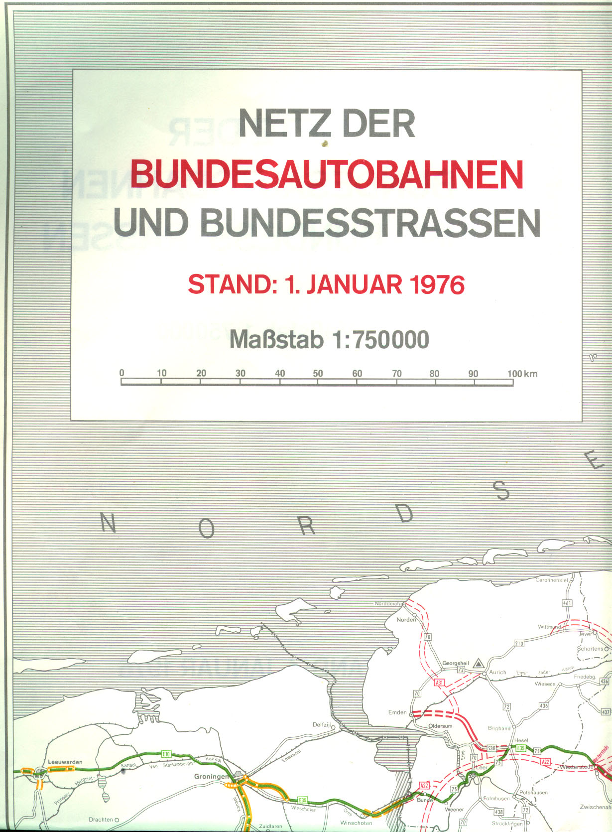
- ↑ Network of federal motorways and federal highways. Status January 1, 1976. Federal Minister of Transport, Road Construction Department, accessed on March 31, 2013 (map excerpt).
- ↑ The Great Shell Atlas, new edition 1977/78, Mairs Geographischer Verlag, Stuttgart 1977/78, pages 12 and 22
- ↑ The Great Shell Atlas, new edition 1979/80, Mairs Geographischer Verlag, Stuttgart 1979/80, pages 12 and 22
- ^ Structure and numbering of the federal highways. Planned overall network. Federal Minister of Transport, Road Construction Department, June 15, 1974, accessed on September 18, 2013 (map excerpt).
- ↑ [1]
- ↑ Second German Television / ZDF, teletext page 593 , accessed on July 28, 2013.
