Muffled
|
Dümpten district 4 of Mülheim an der Ruhr |
|
|---|---|
| location | |
| Basic data | |
| Area : | 5.51 km² |
| Residents : | 18,392 (December 31, 2014) |
| Population density : | 3,338 inhabitants per km² |
| Incorporated on: | April 1, 1910 |
|
District before incorporation: |
District of Mülheim an der Ruhr |
| Postal code : | 45475 |
| Area code : | 0208 |
| structure | |
| District : | Rechtsruhr-Nord |
| District number: | 4th |
| image | |
|
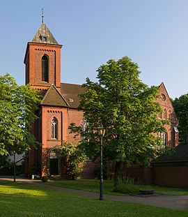
Evangelical Church in Dümpten |
|
Dümpten is an old rural settlement , which lies in the northernmost tip of the Bergisches Land between the Ruhr heights and the Emscherniederung , and only developed into an industrial location in the course of industrialization . In the course of a reorganization of the area, Dümpten was partly assigned to Mülheim and partly to Oberhausen . The Mülheim district is dealt with here.
location
The northernmost Mülheim district of the municipality law Ruhr northern borders Hot , Old Town II and Styrum . It also borders the Oberhausen districts of Styrum and Dümpten and the Essen districts of Bedingrade and Schönebeck . The A 40 cuts through the district. Most of it is north of the A40 motorway.
history

Dümpten belonged together with the Oberhausen district in the late Middle Ages and in the early modern period to the Bergish rule Broich , most recently to the mayor's office of Styrum. Until around the end of the 19th century, the community of Dümpten consisted of scattered courtyards that were connected by paths, for example the Denkhauser Höfe or the old tithe away. Mellinghofer Straße runs along the edge of the Ruhr heights and divides the farming community into Oberdümpten and Unterdümpten. Urban expansion developed mainly along this street. In 1904 Dümpten was separated from the mayor's office in Styrum and then formed its own mayor's office until 1910. The representative building on Mellinghofer Strasse, at the corner of Beutherstrasse, is still called the mayor's office today. It still houses public facilities. The short Beutherstrasse is named after the only mayor of Dümpten.
The district of Dümpten, which was incorporated into Mülheim on April 1, 1910, consists essentially of Oberdümpten. Since the Mayor of Mülheim at the time, Dr. Paul Lembke the northern part of Unterdümpten was too densely populated and also too heavily influenced by mining and colliery colony , he rejected its incorporation and left it to the city of Oberhausen. Mellinghofer Straße, for example, does not belong beyond the autobahn and the area of the former Roland colliery belongs to Oberhausen- Dümpten . For a long time, the parishes in MH-Dümpten attacked the Oberhausen-Dümpten area.
The Dümpten people foster memories of their independence and like to call the place the Kingdom of Dümpten .
On the route of the current A 40, the coal mine railway ran in a straight line from the United Sellerbeck colliery on the edge of Oberdümptens via the Roland colliery to Oberhausen station . Old street names are reminiscent of the area's mining history.
Churches
The Protestant church in Oberdümpten was built in 1892, five years after the establishment of the Protestant community, by the Wuppertal architect Gerhard August Fischer (until 1922 with a pointed 50 m high tower, today 32 m). It was seriously damaged in a bombing raid in November 1944. It was only inaugurated in April 1952 after being rebuilt. It has been a listed building since 1988. The organ comes from the Vlotho organ building company Steinmann . It was rebuilt in 1980 and last extensively restored in 2003/4 by the company Hans van Rossum from Andel, Netherlands. Since summer 2018 it bears the name "Matthäuskirche".
A simple church was built for the Catholics in 1887, which was also bombed on the night of All Saints' Day in 1944. In 1954/5, the new church was built by the architect Alfons Leitl from Trier. It is dedicated to the patron saint of miners, Saint Barbara (→ St. Barbara (Dümpten) ).
For other sights, see the list of architectural monuments in Dümpten
traffic
The district is accessed through Mellinghofer Straße (Landesstraße 450 in the western bypass, then Mannesmann-Straße) and connected to the city center and the A 40. Tram line 102 (→ Tram Mülheim / Oberhausen ) also runs on Mellinghofer Strasse when coming from Oberdümpten .
leisure
In Dümpten, the Hotel Kämpkens Hof operates between the A 40 and the Oberdümpten main access road, the Denkhauser Höfe, as well as tennis facilities, an outdoor pool and a spring-fed fishing pond.
Sons and daughters of Dümpten
- Eduard von Glöden (1801–1861), freemason and art collector
- Wilhelm Füllenbach (1887–1948), lawyer and politician, Lord Mayor of Düsseldorf
- Manuellsen (1979–), musician and actor
Web links
Individual evidence
- ^ According to the map "Section Wesel" by Wilhelm Liebenow . Cf. Viktor Hantzsch: Liebenow, Wilhelm . In: Allgemeine Deutsche Biographie (ADB). Volume 51, Duncker & Humblot, Leipzig 1906, pp. 705-707.
- ^ Service in Dümpten - History ( Memento from April 24, 2005 in the Internet Archive )
- ↑ Monument protection - Dümpten: Where the church tower was once 18 meters higher. Evangelical Church District on the Ruhr, accessed on May 20, 2018 .
- ^ Organs in Mülheim churches - Ev. Church on Oberheidstrasse. Evangelical Church District on the Ruhr, accessed on May 20, 2018 .
- ↑ Dümptener church is now called Matthäuskirche. Evangelical Church District on the Ruhr, June 29, 2018, accessed on February 15, 2019 .
Coordinates: 51 ° 28 ' N , 6 ° 54' E

