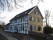
Icked
Ickten is a former monastery , which today is on the one hand a district of Mülheim an der Ruhr , on the other hand a district of Essen - Kettwig . It is located north of the Ruhr and near the A 52 , which leads over the Ruhrtalbrücke here . A motorway parking lot is named after the district.
history
The name Ickten probably comes from a Fronhof that appears in old writings with the name Ickete . In 1350 the Icktener Höfe are mentioned in the Icktener Mark .
Until 1875, Ickten belonged, together with Bredeney , Roßkothen and Schuir , to the Vierhonnschaften community in what was then the Essen district in the Prussian Rhine Province . This was dissolved in 1875, so that the municipality of Dreihonnschaften was formed from Ickten with Roßkothen and the circumstances . In 1927, the mayor's offices in the Rhine Province became offices . The Kettwig-Land office consisted of the municipality of Dreihonnschaften , to which Ickten just belonged.
On August 1, 1929, the Ruhr area was reorganized with the aim of creating large and efficient cities and districts that would last for decades. The agricultural Ickten, which comprised almost 200 inhabitants, was largely incorporated together with Selbeck to Mülheim an der Ruhr. Today this part of Icktens belongs to the Mülheim district of Menden-Holthausen .
The other part of Ickens came to Kettwig in 1929 and thus to the city of Essen within a further regional reform in 1975. In contrast to the rural Mülheim part, it has had extensive residential developments since the 1930s. ▼
The Zinsbach, which flows into the Rossenbeck , is one of the waters .
Web links
Individual evidence
- ↑ a b Andrea Müller: The divided Ickten ; In: Westdeutsche Allgemeine Zeitung of October 5, 2013; accessed on January 30, 2020
- ↑ J. Fricke: TIME SIGN August 1, 1929: Incorporation of Selbeck and Ickten ; In: Mülheim an der Ruhr city archive; accessed on January 30, 2020
Coordinates: 51 ° 23 ' N , 6 ° 54' E
