Broich (Mülheim an der Ruhr)
|
Broich district 8 of Mülheim an der Ruhr |
|
|---|---|
| location | |
| Basic data | |
| Area : | 8.78 km² |
| Residents : | 13,678 (December 31, 2014) |
| Population density : | 1,558 inhabitants per km² |
| Incorporated on: | January 1, 1904 |
|
District before incorporation: |
District of Mülheim an der Ruhr |
| Average Altitude : | 71 m above sea level NHN |
| Postal code : | 45479 |
| Area code : | 0208 |
| structure | |
| District : | Left stirrer |
| District number: | 8th |
| image | |
|
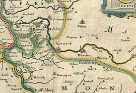
Detail from the Atlas Maior of 1640 |
|
Broich (spoken with a long, closed "o" and a short i) is a district of the independent North Rhine-Westphalian city of Mülheim an der Ruhr . There is Broich Castle , which goes back to an early medieval Hellweg fortress.
location

Broich is located on the historic Hellweg in the Linksruhr district and borders on Speldorf , separated by the Ruhr on the districts of Altstadt I , Altstadt II and also on Saarn and the Duisburg districts of Bissingheim and Neudorf .
Broich was traditionally divided into Unterbroich (located directly on the Ruhr) and Oberbroich, with Oberbroich growing in importance due to the expansion of the settlement in the 1970s, while Unterbroich only left a small settlement area in the 1992 after green area expansion as part of the Mülheim State Garden Show (MüGa) represents newly greened Ruhr meadows .
The place has a mixed housing development. The northern areas are predominantly characterized by multi-family houses from very different years of construction. In the central and southern areas of Broich, on the other hand, there are more and more one- to two-family houses, small apartment buildings and, in some cases, high-rise apartment buildings. In the southernmost area of the village, part of the "Uhlenhorst" residential area is one of the city's most upscale residential areas in Broich. Here, spacious single-family houses with large, partly park-like properties dominate the townscape.
Origin of name
The name Broich goes back to the Lower Franconian name for a quarry (swamp) and means a wetland, especially on river valleys, as can also be found below Broich Castle. On the map from 1640 Broich can be found in the Dutch spelling of the time Broeck (pronounced Bruuk, with Dehnungs -c and Dutch "oe", compare Roer-oort for Ruhrort ). Although the pronunciation “Brooch” (analogous to Grevenbroich and Korschenbroich with Rhenish expansion i ) can be found in the Mülheimer Platt in addition to Brook or Brooke, the pronunciation Broich (with spoken i) predominates today.
schools
In Broich there are four primary schools, as Gemeinschaftsgrundschule led Pestalozzi -Grundschule, the electors primary school, the Catholic primary school Broich and the Urban Community Primary School on Krähenbüschken, also has two secondary schools, namely the Municipal Realschule Broich and the Urban School Broich .
traffic
Until 1968 Broich had a train station on the Kettwig - Styrum line , the Lower Ruhr Valley Railway . The station building was demolished; today there is a children's playground here.
Leisure and culture
The Rauen quarry is located in Broich , where Ruhr sandstone has been mined for decades . As part of this work, a number of Cretaceous fossils were found, most of which are stored and exhibited in the Ruhr Museum .
The MüGa-Park (Mülheims Garten an der Ruhr), which was laid out for the 1992 State Horticultural Show, is located on the former railway site north of the train station . In 1995, the "Ringlokschuppen Mülheim an der Ruhr" cultural center moved into the roundhouse of the former Reichsbahn repair shop in Speldorf.
Sons and daughters (selection)
- Karl Heinrich Schönstedt (1833–1924), politician, Prussian Minister of Justice
Individual evidence
Web links
Coordinates: 51 ° 25 ' N , 6 ° 51' E

