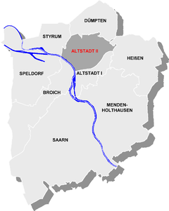
Altstadt II (Mülheim an der Ruhr)
|
Old town II district 2 of Mülheim an der Ruhr |
|
|---|---|
| location | |
| Basic data | |
| Area : | 5.79 km² |
| Residents : | 24,696 (December 31, 2014) |
| Population density : | 4,265 inhabitants per km² |
| Incorporated on: | January 1, 1901 (foundation of the independent city) |
|
District before incorporation: |
District of Mülheim an der Ruhr |
| Postal code : | 45468 and 45473 |
| Area code : | 0208 |
| structure | |
| District : | Rechtsruhr-Süd Rechtsruhr-Nord |
| District number: | 2 |
| image | |
|
Mülheim main station |
|
Altstadt II is a district of the independent , North Rhine-Westphalian city of Mülheim an der Ruhr .
location
The most populous district of Mülheim is in the district Rechtsruhr-Süd, with the exception of the statistical districts Papenbusch (Altstadt-Nord) and Altstadt-Nordost, which belong to Rechtsruhr-Nord. It borders on Styrum , Dümpten , Heißen , Altstadt I and, on the other side of the Ruhr , on Broich .
Web links
Commons : Altstadt II (Mülheim an der Ruhr) - Collection of images, videos and audio files
Coordinates: 51 ° 26 ' N , 6 ° 53' E

