
Sigiriya
| Sigiriya old city | |
|---|---|
|
UNESCO world heritage |
|

|
|
| National territory: |
|
| Type: | Culture |
| Criteria : | (ii) (iii) (iv) |
| Reference No .: | 202 |
| UNESCO region : | Asia and Pacific |
| History of enrollment | |
| Enrollment: | 1982 ( session 6 ) |
| Sigiriya | |||
|---|---|---|---|
|
|||
| Coordinates | 7 ° 57 ' N , 80 ° 46' E | ||
| Basic data | |||
| Country | Sri Lanka | ||
| ISO 3166-2 | LK | ||

Sigiriya (also Sigirija , Sinhala සීගිරිය ˈsiːgirijə ) is a monolith in Sri Lanka on which the ruins of a historic rock fortress are located. The name is derived from "Singha Giri", which means "lion rock". In 1982 Sigiriya was declared a World Heritage Site by UNESCO .
history
In 473 AD, King Dhatusena (ruled 455–473) of Anuradhapura was killed by his son Kassapa, who was born to one of his concubines and thus secured the succession to the throne. Kassapa I (r. 473–491) had the fortress built for fear of his half-brother Moggallana, who was the rightful heir to the throne. In 491 Moggallana returned with an army from exile in southern India and defeated Kassapa, whereupon he became king (ruled 491–508) and made Anuradhapura the capital again.
The attachment
The fortress was located on the erosion ruins of a knoll , which rises about 200 m from the plain and offers a perfect panoramic view. The palace buildings were on the rock, of which only the foundation walls can be seen today, as they were made of wood. There were several cisterns in which collected rainwater was collected in order to have sufficient drinking water supplies available even in the event of a longer siege.
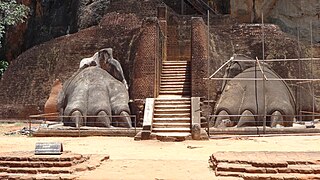
On a plateau on the narrow northern side of the rock are the remains of the lion gate , after which the rock was probably named: Only the two mighty paws remain of the huge lion's head, through whose mouth the last, steepest part of the ascent used to be .
Around the rock was the city surrounded by a moat; the pleasure gardens, which have now been restored, house the remains of fountains, pavilions and a monastery complex.
Today there is also a museum at the entrance to the complex, which shows the history, structure and finds of Sigiriya.

Fortress ruins

Sigiriya (aerial view)

Pleasure gardens

.jpg)


Frescoes, taken in 1970

Cloud Girl, 2002


The frescoes
About halfway up, frescoes of mostly bare-breasted women ( cloud girls ) were made under a rock overhang , which are now accessible via a steel spiral staircase. According to an inscription, there were originally 500 of these drawings, which are strikingly similar to the frescoes in Ajanta . Today 22 of them can still be seen, some of which were restored in the 1970s; in some of them the breasts have been "lifted": in some cases the nipples are drawn higher than in the originals, which can be clearly seen. There is a strict ban on photography for tourists.
The mirror wall
On the way just before the northern plateau is the mirror wall , the plaster of which was polished to a high gloss during the king's lifetime. From the 7th to the 11th century, graffiti was left here, which is the oldest evidence of Sinhala poetry and is of great importance for research into the history of the Sinhala language .
Surroundings
Just a few hundred meters from the rock is Pidurangala , another block of magma that is not quite as high, but offers a good view of the rock fortress. At the bottom of the rock is a small monastery, and on the way up there is a reclining Buddha.

View from the Pidurangala rock

Reclining Buddha below the Pidurangala rock

Downward view

Sigiriya Rock (aerial view)
The lion gate

View of the garden from above


.jpg)


Web links
- Ancient City of Sigiriya / Ville ancienne de Sigiriya on the UNESCO World Heritage Center website ( English and French ).
- Sigiriya - The Lion Mountain (English)
- Sigiriya Official Website (English)
Individual evidence
- ↑ UNESCO World Heritage Center: Ancient City of Sigiriya. Retrieved on August 24, 2017 .
- ↑ Do not take photos of the cloud girl from Sigiriya in Sri Lanka. In: DerWesten.de. Funke Mediengruppe , March 24, 2017, accessed September 9, 2017 .

Heritage: Holy City of Anuradhapura (1982) | Polonnaruwa Old City (1982) | Old City of Sigiriya (1982) | Holy City of Kandy (1988) | Old town of Galle and its fortifications (1988) | Golden Temple of Dambulla (1991)
Natural heritage: Sinharaja Forest Nature Reserve (1988) | Central Highlands of Sri Lanka (2010)