
Rossenbeck
| Rossenbeck | ||
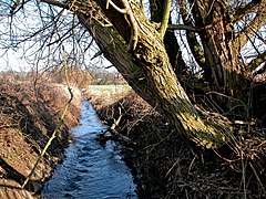
 The Rossenbeck, looking east |
||
| Data | ||
| Water code | DE : 276992 | |
| location | Germany | |
| River system | Rhine | |
| Drain over | Ruhr → Rhine → North Sea | |
| source | in Essen-Kettwig 51 ° 23 ′ 54 ″ N , 6 ° 56 ′ 43 ″ E |
|
| Source height | 118 m above sea level NHN | |
| muzzle | in Mülheim in the Ruhr Coordinates: 51 ° 23 '20 " N , 6 ° 53' 52" E 51 ° 23 '20 " N , 6 ° 53' 52" E |
|
| Mouth height | 37 m above sea level NHN | |
| Height difference | 81 m | |
| Bottom slope | 20 ‰ | |
| length | 4.1 km | |
| Catchment area | 7.06 km² | |
| Left tributaries | Zinsbach | |
| Right tributaries | Rohmbach | |
| Big cities | Essen , Mülheim an der Ruhr | |
The Rossenbeck , also called Rossenbach, is a 4.1 kilometer long right tributary of the Ruhr in Mülheim an der Ruhr . It is the third from last major tributary before the Ruhr flows into the Rhine 19.2 kilometers further .
geography
course
The Rossenbeck rises in the Essen district of Essen-Kettwig and flows into the Ruhr in the Menden district in Mülheim . The stream flows largely in its natural bed. A former mill pond is attached to the Stinshoff farm just above Mendener Strasse. From there it is led in an open canal, under the road and the towpath through a tube, to the Ruhr.
The Rossenbeck valley above the Mühlteich and the Rohmbachtal are among the nature reserves in Mülheim.
- Bach impressions

View into the Rossenbeck valley to the west

The mill pond at Farmer Stinshoff

Underpass on Mendener Strasse
The Rossenbeck in front of the estuary


Tributaries
The notable tributaries of the Rossenbeck include the Rohmbach and the Zinsbach.
Individual evidence
- ↑ a b German basic map 1: 5,000
- ↑ a b Topographical Information Management, Cologne District Government, Department GEObasis NRW ( Notes )