
Federal motorway 63
| Bundesautobahn 63 in Germany | ||||||||||||||||||||||||||||||||||||||||||||||||||||||||||||||||||||||||||||||||||||||||||||||||||||||||||

|
||||||||||||||||||||||||||||||||||||||||||||||||||||||||||||||||||||||||||||||||||||||||||||||||||||||||||
| map | ||||||||||||||||||||||||||||||||||||||||||||||||||||||||||||||||||||||||||||||||||||||||||||||||||||||||||
 |
||||||||||||||||||||||||||||||||||||||||||||||||||||||||||||||||||||||||||||||||||||||||||||||||||||||||||
| Basic data | ||||||||||||||||||||||||||||||||||||||||||||||||||||||||||||||||||||||||||||||||||||||||||||||||||||||||||
| Operator: |
|
|||||||||||||||||||||||||||||||||||||||||||||||||||||||||||||||||||||||||||||||||||||||||||||||||||||||||
| Start of the street: |
Mainz ( 49 ° 58 ′ N , 8 ° 14 ′ E ) |
|||||||||||||||||||||||||||||||||||||||||||||||||||||||||||||||||||||||||||||||||||||||||||||||||||||||||
| End of street: |
Autobahn triangle Kaiserslautern ( 49 ° 28 ′ N , 7 ° 48 ′ E ) |
|||||||||||||||||||||||||||||||||||||||||||||||||||||||||||||||||||||||||||||||||||||||||||||||||||||||||
| Overall length: | 73 km | |||||||||||||||||||||||||||||||||||||||||||||||||||||||||||||||||||||||||||||||||||||||||||||||||||||||||
|
State : |
||||||||||||||||||||||||||||||||||||||||||||||||||||||||||||||||||||||||||||||||||||||||||||||||||||||||||
|
Course of the road
|
||||||||||||||||||||||||||||||||||||||||||||||||||||||||||||||||||||||||||||||||||||||||||||||||||||||||||
The federal motorway 63 (abbreviation: BAB 63 ) - short form: Autobahn 63 (abbreviation: A 63 ) - is a German motorway that leads from Mainz to Kaiserslautern . It connects the Rhine-Main area with the greater Saarbrücken area , from where there is a cross-border connection to France with the BAB 6 . The motorway is therefore of supraregional importance.
The BAB 63 was built between Mainz and Alzey in the 1970s, with the establishment of the alternate seat of the Rhineland-Palatinate state government in Alzey being one of the decisive factors for the completion of this section. The continuation to Kaiserslautern was opened in its last section in October 2004.
history
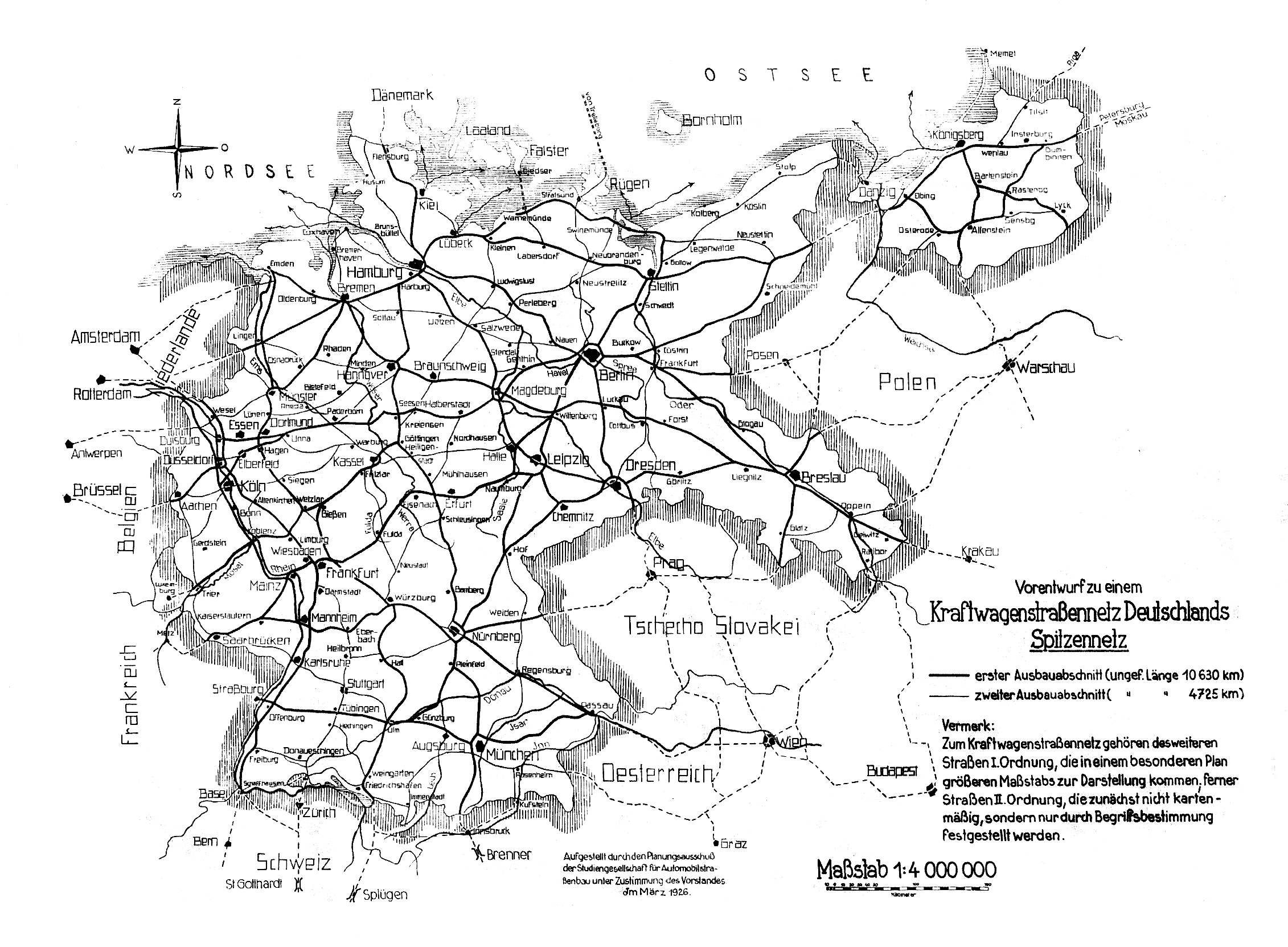
In the “Preliminary Draft for a Motor Vehicle Road Network in Germany” of March 1926, the planning committee of the Study Society for Automobile Road Construction suggested a route from Frankfurt am Main via Mainz, Kaiserslautern and Saarbrücken to France for the first expansion section. The route mainly referred to the Kaiserstraße built under Emperor Napoleon Bonaparte .
It took almost 30 years to complete the approximately 73-kilometer-long motorway between Mainz and Kaiserslautern. The first section from the Mainz-Süd junction to the Nieder-Olm junction was opened to traffic in 1976, the section between Wörrstadt and the Alzey junction in 1978. Two years later, in 1980, the gap between Nieder-Olm and Wörrstadt was closed and the A 63 was thus completely passable between Mainz and Alzey, which also brought a strategic advantage for the state government in Mainz, since the alternative seat of the state government of Rhineland-Palatinate in Alzey could be reached more quickly in possible crises. A year later, in 1981, the south adjoining section up to the Freimersheim junction with the Weinheim viaduct was completed. The further construction in the direction of Kaiserslautern took a little longer, however, so the next section between Kirchheimbolanden and a provisional junction near Steinbach was not completed until 1989. In 1993 the gap between Freimersheim and Kirchheimbolanden was closed and in 1996 the autobahn from Steinbach to Winnweiler was extended, eliminating the provisional end of the autobahn. A year later, in 1997, the motorway ended in a southerly direction at another provisional junction near Lohnsfeld . This did not apply in 1999 when the A 63 reached Sembach . The last section between Sembach and the Kaiserslautern triangle was completed in 2004. Since then, the entire length of the A 63 has been drivable.
route
course
The A 63 starts at the Mainz-Süd (2) junction as an extension of the B 40 coming from Mainz . From this junction with the A 60 , the southern Mainzer Ring , it runs mostly in a south to south-westerly direction through the Rheinhessen hill country , largely following the earlier course of the B 40, which was downgraded to a country road in the course of the construction of the A 63 . Since November 2009, the originally four-lane section from the beginning of the motorway to the Nieder-Olm junction (4) has been equipped with a temporary hard shoulder release due to the high volume of traffic , which is to be extended to the subsequent Saulheim junction (5).
At Wörrstadt (6), a large wind farm , the Wörrstadt energy park , was built along the motorway between 2009 and 2012 , which is also in the immediate vicinity of the company headquarters of juwi , the operator of the park. A little further to the south-west you reach the Alzey motorway junction (8), which connects the A 63 with the A 61 . The crossings from Mainz to the A 61 in the direction of Ludwigshafen and vice versa were carried out in two lanes and as semi-direct connecting ramps, since until the completion of the A 63 near Sembach in 2004 all heavy goods traffic was routed via the A 61 and from the Frankenthal junction via the A 6 .
Behind the cross, the district town of Alzey is bypassed to the west and connected to the Erbes-Büdesheim (9) and Freimersheim (10) junctions . The longest bridge structure on the entire motorway, the 1.2 km long Weinheim Viaduct, is located between the two connections . Shortly before the Kirchheimbolanden junction (11) there is one of only two unmanaged rest areas on the motorway called “ Heubergerhof ”. The second then follows behind the Göllheim junction (12) and bears the name “ Donnersberg ”. The mountain of the same name is located directly to the north of the motorway and can be recognized from afar thanks to its distinctive television tower ( Sender Donnersberg ) and the former radio station on its summit. The landscape becomes more hilly and wooded and the motorway crosses the northernmost foothills of the Palatinate Forest . The journeys over the numerous valley bridges in this section offer impressive views of the nearby North Palatinate mountains .
The last section between Sembach (14) and the Kaiserslautern motorway triangle has a winding route and a distinctive gradient to the south. In the triangle itself there is another junction that leads to the center of Kaiserslautern. The connection from the A 63 to the A 6 in the direction of Mannheim is also made possible via this exit. The main lanes of the A 63 lead to the A 6 in the direction of Saarbrücken .
Nodes


expansion
Since November 2009, the route between the Mainz-Süd motorway junction and the Nieder-Olm junction has been expanded to include six lanes. The respective acceleration lanes from Nieder-Olm in the direction of Mainz and the transition from the A 60 from the direction of Bingen am Rhein to Nieder-Olm were converted into a third lane. After approx. 7 km from both directions you will then turn into a delay lane for the Nieder-Olm exit or the transition to the A60 in the direction of Frankfurt am Main .
For this purpose, the original hard shoulder from Klein-Winternheim to the Nieder-Olm junction was structurally reinforced between mid-September and the end of December 2007 so that it can be used as an additional third lane. At first, however, this was used from the beginning of May to mid-August 2008 to relocate the opposite lane to this lane so that a complete renewal of the lane between Nieder-Olm and Klein-Winternheim could take place. Subsequently, the deceleration lane at the Klein-Winternheim junction was moved further to the right by December 9, 2008, so that a continuous six-lane road layout could now take place from the Nieder-Olm junction and the Mainz-Süd junction in order to relieve the morning rush hour traffic via another lane because up to 60,000 vehicles pass this point every day. With the elimination of the hard shoulder, additional emergency bays were necessary.
After that, the roadway from Klein-Winternheim in the direction of Nieder-Olm was completely renovated by November 2009 and the noise protection for the municipality of Ober-Olm located directly on the motorway was improved. The Klein-Winternheim junction was moved further to the right in order to have three lanes between the Mainz-Süd and Nieder-Olm intersections. Since the hard shoulder had to give way to the third lane on this side as well, the emergency bays were created during the repair work in 2007.
Road construction work between Nieder-Olm and Klein-Winternheim was completed at the beginning of November 2009. Between April and September 2011, new sign gantries and several intelligent traffic sign systems as well as surveillance cameras from Funkwerk were installed on this section of the route for a temporary hard shoulder clearance (TSF). The cameras are used for traffic telematics to in dangerous situations (accidents and breakdowns) the page strip , to lock again, after a previous release. The TSF has been in operation since April 16, 2012.
In April 2013, the construction work for the expansion and extension of the TSF from Nieder-Olm after Saulheim began to extend, as an in Saulheim Package Center of the Deutsche Post DHL is. The construction work was originally supposed to last until July 2013, according to the construction site information sign, but was then extended by a month and then extended to December 2013 in September. So far (as of March 2019) no TSF system has been installed between the Nieder-Olm and Saulheim junctions.
The special noise-reducing asphalt placed on the roadway between Saulheim and Nieder-Olm showed holes after a year because it was incorrectly applied. The carriageway therefore had to be completely milled and rebuilt over a weekend. The road construction company bore the costs of the renovation.

dWiSta (intelligent display board) just before the Mainz-Süd junction. Indication of a traffic jam on the A60 towards Frankfurt with a recommendation on the A643 and the A66 to Frankfurt to drive
(2012)
The same display board this time with a diversion notice to drive over the A 60 and A 671 to Wiesbaden because of the closed Schiersteiner Bridge (February 2015).

Even before the intelligent display board was installed, a permanently installed sign was erected in the mid-2000s, which can be opened if necessary and indicates that the Schierstein Bridge is closed.


Speed limits
There are speed limits at several points along the motorway. On the B40 , the continuation of the A 63 north, 70 km / h applies for noise protection reasons.
Speed limits A63 (Mainz -> Kaiserslautern)
| Mainz-Süd motorway junction | From km 2.0 | 100 km / h / 130 km / h | Temporary hard shoulder release (TSF) |
| Nieder-Olm | From kilometer 9.0 | Unlimited | |
| AS Erbes-Büdesheim | From kilometer 30.0 | 130 km / h | Cross wind on the Weinheim Viaduct |
| AS Freimersheim | From kilometer 33.5 | Unlimited | |
| AS Winnweiler | From kilometer 59.5 | 130 km / h | |
| AS Sembach | From km 63.0 | Unlimited | |
| AS Kaiserslautern | From 68.5 km | 130 km / h | Tight bends and risk of traffic jams before the transition to the A6 |
| AS Kaiserslautern | From kilometer 69.5 | 100 km / h | |
| Kaiserslautern motorway triangle | From 71.5 km | 100 km / h | Variable message signs in front of the transition to the A6 |
Traffic significance
The A 63 connects the cities of Mainz and Kaiserslautern in Rhineland-Palatinate . The motorway therefore initially has a regional character. The expansion of the motorway, which was completed on October 15, 2004, will shorten journeys between Saarland or France and the Rhine-Main area .
In the manual road traffic census of the Federal Highway Research Institute, which is carried out every five years, an "average daily traffic volume" (DTV) between 24,000 and 63,000 vehicles per day with a 10.3 percent share (median value) of heavy traffic (buses, trucks> 3.5 t gross vehicle weight with and without trailers, articulated lorries) determined on all vehicles in 2010. Five years earlier, in 2005 there were between 20,400 and 60,700 vehicles (10.1%).
The most frequented section in the 2010 traffic census is between the Mainz-Süd motorway junction and the Klein-Winternheim junction. After that, vehicle traffic will steadily decrease. Between the interchanges in Kirchheimbolanden and Göllheim it then reaches its lowest capacity utilization with 24,000 vehicles per day. It is the same section as in 2005.
In addition, the highway is also the fastest connection for the American armed forces to drive between their headquarters of the United States Air Forces in Europe at Ramstein Air Base near Kaiserslautern to the US Army Europe land forces in the Lucius D. Clay barracks in Wiesbaden.
particularities
Truck stops and parking lots
There are no rest areas on the oldest stretch between Mainz and Alzey. There are rest areas only at Kirchheimbolanden and a few kilometers further on on Donnersberg. In August 2008, plans for a truck stop at the Wörrstadt junction were announced. However, plans for a truck stop at the next Biebelnheim junction have been known since the mid-1990s. According to the competent authority, both projects could not be approved in August 2008. Six months later, the first facts and results should be announced at information events. In September 2009, approval was given for the Wörrstadt truck stop, which was originally supposed to be completed in 2010. The municipality Wörrstadt turned early 2015, the Ministry of Economy on after an agreement with the Ministry of Infrastructure seemed impossible, as the costs for the drainage of the area became the subject-matter. In the opinion of the Verbandsgemeinde, the costs of the state, which they have provided on behalf of the federal government, are far too high. Likewise the costs for the necessary gyro.
In the first half of 2019, the Wörrstadt junction with roundabouts was converted to better connect the future truck stop to the main road and motorway. The groundbreaking ceremony for the truck stop near Wörrstadt took place on June 17, 2019.
A planned tank and rest area in place of the Donnersberg car park near Steinbach am Donnersberg has so far failed due to the protest of residents. A smaller variant, in which only additional parking spaces but no rest area will be built, is now to be realized, but is also met with protests from residents. A realization is therefore uncertain.
Because there is currently no parking space, many truck drivers use the emergency bays in the section between Klein-Winternheim and Nieder-Olm to take their breaks. Since the end of January 2018, signs below the emergency stop board ( ![]() ) have been pointing out in English that this is not a resting place for eating and sleeping.
) have been pointing out in English that this is not a resting place for eating and sleeping.
Tourist information signs

There are tourist signs on the motorway that point to sights in the immediate vicinity away from the motorway.
- Mainz Cathedral (after the Nieder-Olm AS in the direction of Mainz)
- Katharinenkirche Oppenheim (in front of the AS Wörrstadt)
- former pilgrimage church Armsheim ( Armsheim , in front of AS Biebelnheim)
- Rheinhessen (in the direction of Mainz in front of the AS Freimersheim)
- Celtic Donnersberg (in the direction of Kaiserslautern in front of the AS Kirchheimbolanden)
- Kirchheimbolanden - Small Residence (in front of the AS Kirchheimbolanden)
- Roman park Vicus Eisenberg (in front of AS Göllheim)
- Otterberg Abbey Church (only in the direction of Kaiserslautern, in front of AS Sembach)
- Palatinate Forest Nature Park - Palatinate Forest-Northern Vosges Biosphere Reserve (only in the direction of Kaiserslautern in front of the Kaiserslautern triangle )
- Japanese Garden Kaiserslautern (only in the direction of Kaiserslautern in front of the Kaiserslautern triangle )
With the exception of the Katharinenkirche information sign , all the destinations to which the information refers are within a radius of approx. Five kilometers. The Katharinenkirche, on the other hand, can be reached over 20 km east of the motorway via the B 420 .
Bulky pile in 1998
In March 1998 a pile-up occurred on the section between Wörrstadt and Biebelnheim after a sandstorm. Strong wind whirled up the sand on the adjacent, dust-dry fields and got onto the motorway and blocked a total of 26 vehicles from sight. Three people were seriously injured and eight were slightly injured.
Football World Cup 2006


Between January 13th and August 8th, 2006, between the Wörrstadt and Saulheim junctions, near the town of Udenheim (between 14.5 and 14.0 kilometers of motorway ), there was a sign pointing to the 2006 World Cup . The sign was roughly midway between the two World Cup cities of Kaiserslautern and Frankfurt am Main .
Another sign was in the direction of Kaiserslautern between Göllheim and Winnweiler at kilometer 48.5.
Individual evidence
- ↑ Map for the preliminary draft of a motor vehicle road network Germany's top network. Established by the planning committee of the Study Society for Automobile Road Construction with the approval of the board in March 1926
- ↑ Maps of Germany show the drafts of the motorway network in Germany from 1926 to 1935 online on the Internet: October 7, 2011
- Jump up ↑ New 24-hour truck stop in Wörrstadt on the A63. 24-autohof.de, accessed on December 10, 2019 .
- ↑ New building in 1976
- ↑ New building in 1978
- ↑ New building in 1980
- ↑ New building in 1981
- ↑ New building in 1989
- ↑ New building in 1993
- ↑ New building in 1996
- ↑ New building in 1997
- ↑ New building in 1999
- ↑ New building in 2004
- ↑ Permanent construction site A63 until 2009 - renovation and additional lanes between Klein-Winternheim and Nieder-Olm in the Rhein Main Presse of October 23, 2007
- ↑ Traffic management: hard shoulder release on the A 63 as of April 16, 2012
- ↑ Temporary hard shoulder release on the A 63 between the Saulheim junction and the Mainz-Süd motorway junction online on the Internet: May 3, 2012
- ↑ Information sign: We build for you
- ↑ Nieder-Olm: New motorway surface after a year with holes in it on swr.de from August 22, 2014
- ↑ Temporary hard shoulder release. State Office for Mobility Rhineland-Palatinate, accessed on March 10, 2019 .
- ↑ Traffic control system RLP. (JPEG) Landesbetrieb Mobility Rhineland-Palatinate, accessed on March 10, 2019 .
- ↑ Manual road traffic census 2010 (as of November 11, 2011) ( Memento of March 3, 2016 in the Internet Archive ) PDF file; Page 28
- ↑ Municipal council sets the course for the Autohof - Wörrstadt parliamentary groups decide on the development plan for a major project on the A63 exit on August 20, 2008 in the Rhein Main Presse
- ↑ Traffic density is a problem child - politicians see a need for action in Wörrstadt on August 20, 2008 in the Rhein Main Presse
- ↑ Construction project encounters opposition - Autohof is also to be built on the A63 in Biebelnheim / critics refer to increased pollution in the Allgemeine Zeitung of August 29, 2008
- ↑ Page no longer available , search in web archives: Council decides today on resident application - the subject of the truck stop is at the top of the agenda in Biebelnheim / local boss Holla sees majority for the project in the Rhein-Main-Presse of September 12, 2008
- ↑ Local boss says information to citizens - Autohof topic in the Biebelnheimer Rat in the Allgemeine Zeitung from September 15, 2008
- ↑ No green light for projects yet - district building authority chief on truck stop plans in the Allgemeine Zeitung of August 29, 2008
- ↑ Authority agrees - AUTOHOF Important hurdle for Wörrstadt project taken by Thomas Ehlke in Allgemeine Zeitung on September 25, 2009
- ↑ In mid-February facts on the table - Autohof projects in Biebelnheim and Wörrstadt in the Allgemeine Zeitung of January 23, 2009
- ↑ Anita Pleic: Is the truck stop about to end? in Rhein Main Presse (Allgemeine Zeitung) on January 21, 2015
- ↑ Groundbreaking ceremony: businessPARK Wörrstadt with 24-car stop As of June 17, 2019; online on the Internet: September 3, 2019
- ↑ Opponents and supporters meet: Discussion about A63 rest area expansion near Steinbach - SWR
- ↑ A 63: More and more trucks are parking in the emergency parking bays by Anita Pleic on Allgemeine-Zeitung.de of October 18, 2017
- ↑ ( page no longer available , search in web archives: news sheet of Verbandsgemeinde Wörrstadt, Volume 43, No. 29, July 22, 2010, title page ) PDF file (189 kB)
- ^ Rhein-Main-Presse, Allgemeine Zeitung, without page number (section: Panorama), April 9, 2011
Web links
- Detailed route description of the federal motorway 63
- Information and pictures for the complete completion of the Rhineland-Palatinate Mobility Agency
- Notes on current construction sites
- Images direction Mainz – Kaiserslautern (July 2006)
- Pictures driving direction Kaiserslautern – Mainz (July 2006)
- Photo series of the entire route, both directions (2013)
- Open letter from the CDU parliamentary group of VG Nieder-Olm to the then Minister Bauckhage dated May 17, 2005
